Ranikot
This is a collection of articles archived for the excellence of their content. Readers will be able to edit existing articles and post new articles directly |
Ranikot
Ranikot: restoration or devastation?
By Bhagwandas
Moving 75kms away from Jamshoro on the Indus Highway, one has to take a left turn and travel another 26kms on a narrow road flanked by hillocks to see solid stone walls of a fort constructed high on a hilltop. It is called the Ranikot Fort, and is believed to be one of the largest forts in the world.
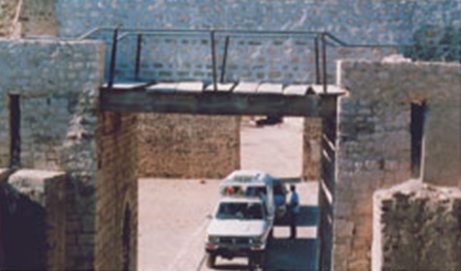
The narrow road leads to the fort through the Sann gate, named after a town, Sann. Mohen Nai is a water stream that enters the fort from its rarely used western Mohen gate and is guarded by a small fortification. It gets into a series of turquoise pools to irrigate the fields and leaves the fort from its most used Sann gate on the eastern side. Apart from these, there are two more gates -- rather gate-like structure. One is the Amri gate (facing the ruins of the ancient town of Amri); and the other is the Shahpir gate on the southern side that is named after a limestone rock with a footprint on it.
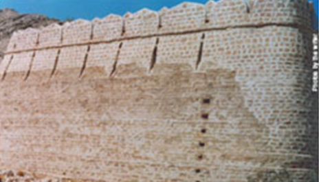
The approximately 10-metre high massive and undulating walls constructed with sandstone that are around 30kms in circumference were originally constructed for the bow-and-arrow warfare that used to take place in the past, but were later strengthened to sustain and support firearms. The walls were remade with bastions and a dip over the hills of the Khirthar mountain range.
A mountainous ridge, Karo Takkar, running north to south, forms the fort’s western boundary and the Lundi Hills form its eastern boundary. Most of the boundary walls are made of natural cliffs and rocks, rising as high as 2,000ft above sea level at certain places.
As one enters the fort one can find valleys, streams, hills, ponds, ditches, bastions, watch towers, and fortresses all around. A spring emerging from an underground water source near the Mohen gate is called Parriyun Jo Tarr (the spring of ferries), and another such spring is located near Karo Jabal, and is called Wagoon Jo Tarr (crocodiles’ spring).
Ranikot and Merikot structures (located some six kilometres from the Sann gate in the heart of Ranikot) have similar entrances – curved and angular with a safe path. Located about a 1,000ft above Merikot is Shergarh (the abode of lions) made of whitish stones.
The condition of this centuries’ old historic site had been consistently deteriorating owing to the negligence on the part of the government, particularly its federal archaeology department. Then, recently, the Sindh culture department and the Dadu district government started restoration work on the structure, but owing to the lack of technical expertise in the field of restoration and rehabilitation work, the fort remained in a poor condition for quite long.
Cement was used in the restoration and rehabilitation work on the fort not only as binding material but also for layering the surface of the stones. This marred the visual appeal of the historic site and its natural surroundings.
Everybody knows that cement causes disintegration in historic buildings because it is denser and stronger than materials like stones and lime mortar. Owing to its high density and low porosity, it absorbs water at a much quicker rate and dries up slowly. The restoration and rehabilitation work was carried out on the walls, on the Sann gate, on platforms before Meri Kot, and on a mosque near the Sann gate using cement extensively. Even a metalled road was constructed right inside the fort up to Meri Kot. This probably was done to facilitate the VIPs so that they did not have to walk while witnessing the fort.
New cement masonry was used on top of the ancient walls, which is contrary to the principles and ethics of ancient monuments’ conservation. At many places the surface of the walls was scrapped to level it, damaging the historical building in the process. The cement-pointing done on platforms was higher than the level of the stones, creating small pits which would retain water during rainfall and the soluble salts would seep through the stones.
The dome of the mosque in the fort was plastered with cement that completely ruined its historic character. It now needs to be chiselled and the dome should be re-plastered with lime mortar to restore its originality.
It is interesting to note that three government organisations -- the federal archaeology and museum department, the Sindh culture department, and the district government -- were involved in the project and despite the fact that millions of rupees from public fund were spent the destruction of the historical site remained unnoticed.
Thankfully, recently common sense prevailed and the destructive “restoration” work on the fort has now been stopped. The federal archaeology department is making efforts and has approached Unesco to get the Ranikot fort on the list of the World Heritage Sites.

