Earthquakes: India
This is a collection of articles archived for the excellence of their content. Readers will be able to edit existing articles and post new articles directly |
60% of subcontinental landmass is vulnerable
Thirty-eight Indian cities in high-risk earthquake zones
At least 38 Indian cities lie in high-risk seismic zones and nearly 60 percent of the subcontinental landmass is vulnerable to earthquakes. Barring rare exceptions, such as the Delhi Metro, India's hastily-built cities are open to great damage from earthquakes.
The earthquake that devastated Nepal on saturday and jolted northern India, damaging buildings as far apart as Agra and Siliguri, was expected by geologists, who have warned of more Himalayan earthquakes caused by the growing pressures of the sub-continent grinding into the Asian mainland.
Very few buildings in India meet the standards prescribed in "Indian Standards Criteria for Earthquake Resistant Design" - first published by the Bureau of Indian Standards in 1962, the latest revision being in 2005. These are not enforced, so almost no one knows such earthquake-resistant standards and guidelines for home-owners exist.
The Delhi Metro is one of the few Indian structures built to withstand a quake. Many of the houses built in Bhuj after the Gujarat quake of 2001 are now earthquake-resistant.
The government of India today lists 38 cities in moderate to high-risk seismic zones. "Typically, the majority of the constructions in these cities are not earthquake-resistant," notes a 2006 report written by the United Nations for the ministry of home affairs. "Therefore in the event of an earthquake, one of these cities would become a major disaster."
The earth's landmasses ride like gigantic rafts on "plates", or sections of the earth's outermost layer, the crust. These plates frequently slip and slide, causing earthquakes. We don't feel the small ones. The big ones, literally, shake us up.
The Himalayas and north India are on particularly shaky ground. Sometime in the geological past, before humans, India broke off from an ancient supercontinent called Gondwana, a name still used for what is now Chhattisgarh.
The Indian plate skewed north, displaced an ancient sea, travelled more than 2,000 km - the fastest a plate has ever moved - and slammed into the Eurasian plate, creating the Himalayas.
India still grinds northeast into Asia at roughly 5 cm every year. The last significant - but not geologically significant - quake in this area was the 2005 temblor in Pakistan-administered Kashmir, which sits directly atop the clashing Indian and Eurasian plates. Around 80,000 people died.
About 60 percent of India is vulnerable to earthquakes caused by the great, northward grind of the Indian subcontinental landmass.
History
But nothing has changed since 1993, when a relatively milder earthquake of magnitude 6.4 in Maharashtra's Latur district killed nearly 10,000 people in what was considered a non-seismic zone. Most died because shoddily constructed houses collapsed at the first major shake, as they did in Gujarat eight years later.
The only serious earthquake that modern India remembers is the temblor that killed about 20,000 in Gujarat in 2001. The 2004 tsunami, which resulted from the third-most severe quake ever recorded, 9.3 on the Richter scale, occurred when the Indian plate slid with greater violence than it normally does under the neighbouring Burma plate, upon which rest the Andaman and Nicobar Islands.
It caused a 100-km-long rupture in the crust, thrusting the seafloor upwards and pushing up masses of water, setting off the tsunami that killed 230,000 people in 14 countries.
No Indian metropolis has witnessed a serious earthquake, although Delhi lies in high-risk seismic zone 4. Srinagar and Guwahati are in the highest-risk zone 5, and Mumbai, Chennai and Kolkata lie in zone 3. History serves a warning that a big one may come at any time. Those lessons come from Bihar in 1934 and Assam in 1950.
Although its epicentre was 10 km south of Mount Everest, the Bihar earthquake of 1934 was felt from Mumbai to Lhasa, flattening almost all major buildings in many Bihar districts and damaging many in Calcutta, now Kolkata. At 8.4 on the Richter scale, it was pretty severe, killing more than 8,100 (Mahatma Gandhi said it was punishment for the sin of untouchability).
The 1950 Assam earthquake may have geologically set the stage for a really big one in the Himalayas, according to geologists. Now that 65 years have passed, it may be time for a big one.
(In arrangement with Indiaspend.org)
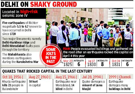
Delhi: located in ‘high-risk’ seismic zone IV
Disaster authority for stricter quake norms
Ambika Pandit TNN
The Times of India 2013/08/06
Delhi is located in the ‘high-risk’ seismic zone IV. The Vulnerability Atlas of India (1997) says for shaking intensity eight, 6.5% houses in Delhi have high damage risk and 85.5% houses have moderate damage risk. “Most buildings may not meet codal requirements on seismic resistance. Disaster prevention involves engineering intervention in buildings and structures to make them strong enough to withstand the impact of natural hazard,” said DDMA divisional commissioner Dharampal.
DDMA has observed that ill-designed high-risk areas and highrises exist in Delhi without specific consideration of earthquake resistance. “Connaught Place, numerous district centres and sprouting highrise group housing schemes are high risk areas due to the vertical development and plan configurations,” DDMA concedes. The Walled City, trans-Yamuna area, and scattered pockets of unplanned settlements also figure as high-risk zones due to their substandard structures and high density.
