Earthquakes: India
This is a collection of articles archived for the excellence of their content. Readers will be able to edit existing articles and post new articles directly |
Contents |
Indian regions vulnerable to earthquakes
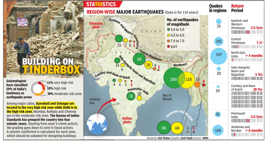
59% of India vulnerable
59% of India vulnerable to moderate to severe quakes, Dipak Dash, Sep 21 2016 : The Times of India
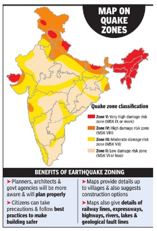
Nearly 59% of India's land area is vulnerable to moderate or severe earthquakes, according to the latest seismic zone map released on Tuesday . It also shows how out of the total 304 million households in the country, about 95% are vulnerable to earthquakes in different degrees.
In the next three months, the map will be accessible on your mobile phone to know how quake-prone your home or office is. The map has been prepared by National Disaster Management Authority (NDMA) and Building Materials and Technology Promotion Council (BMTPC).
The earthquake zoning maps provides details down to the block level. “The maps will be digitised and the agencies will launch a mobile app so that every citizen can benefit from this. While the access to this information will help planners, it will guide citizens to take preventive steps,“ urban housing development minister M Venkaiah Naidu said while releasing the colour-coded maps.
The colour-coding easily conveys location in five different zones of earthquake intensity . These maps show the boundaries of hazard zones of various intensities. “The real benefit will be that people can locate themselves in their district boundary and find the possible intensity of quakes.After assessing the risk level, they can take appropriate action including retrofitting the buildings or houses to sustain any seismic hazard,“ said MoS (urban housing) Rao Inderjit Singh. The maps will also help the district authorities to determine the location and area most susceptible to intense hazard occurrences.
The information can become the basis for formulating preventive action to reducing the impact of the hazard, installation of a warning system and formulating building bye-laws with seismicresistant features.
The earthquake zoning maps will also help the state and central authorities to identify the districts most prone to severe disaster situations, and those with multihazard situations, requiring priority action in future planning and formulating integrated mitigation policies.
“Even development projects will need to include mitigation measures against the disaster impacts at the initial plan formulation, as well as execution stages, so that whatever is developed should not suffer damage later. The atlas will be immensely useful for this,“ a housing ministry official said.
Thirty-eight Indian cities vulnerable
Thirty-eight Indian cities in high-risk earthquake zones
At least 38 Indian cities lie in high-risk seismic zones and nearly 60 percent of the subcontinental landmass is vulnerable to earthquakes. Barring rare exceptions, such as the Delhi Metro, India's hastily-built cities are open to great damage from earthquakes.
The earthquake that devastated Nepal on saturday and jolted northern India, damaging buildings as far apart as Agra and Siliguri, was expected by geologists, who have warned of more Himalayan earthquakes caused by the growing pressures of the sub-continent grinding into the Asian mainland.
Very few buildings in India meet the standards prescribed in "Indian Standards Criteria for Earthquake Resistant Design" - first published by the Bureau of Indian Standards in 1962, the latest revision being in 2005. These are not enforced, so almost no one knows such earthquake-resistant standards and guidelines for home-owners exist.
The Delhi Metro is one of the few Indian structures built to withstand a quake. Many of the houses built in Bhuj after the Gujarat quake of 2001 are now earthquake-resistant.
The government of India today lists 38 cities in moderate to high-risk seismic zones. "Typically, the majority of the constructions in these cities are not earthquake-resistant," notes a 2006 report written by the United Nations for the ministry of home affairs. "Therefore in the event of an earthquake, one of these cities would become a major disaster."
The earth's landmasses ride like gigantic rafts on "plates", or sections of the earth's outermost layer, the crust. These plates frequently slip and slide, causing earthquakes. We don't feel the small ones. The big ones, literally, shake us up.
The Himalayas and north India are on particularly shaky ground. Sometime in the geological past, before humans, India broke off from an ancient supercontinent called Gondwana, a name still used for what is now Chhattisgarh.
The Indian plate skewed north, displaced an ancient sea, travelled more than 2,000 km - the fastest a plate has ever moved - and slammed into the Eurasian plate, creating the Himalayas.
India still grinds northeast into Asia at roughly 5 cm every year. The last significant - but not geologically significant - quake in this area was the 2005 temblor in Pakistan-administered Kashmir, which sits directly atop the clashing Indian and Eurasian plates. Around 80,000 people died.
About 60 percent of India is vulnerable to earthquakes caused by the great, northward grind of the Indian subcontinental landmass.
Vulnerable regions: NIDM (National Institute of Disaster Management)
Apr 27 2015
Pradeep Thakur
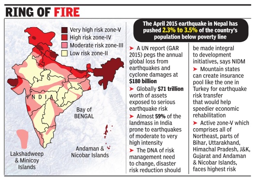
NE, Bihar, U'khand, J&K, Himachal, Gujarat, Andamans at high risk
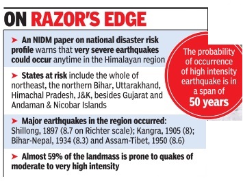
An assessment made by the Centre says the entire Himalayan region is vulnerable to high intensity earthquakes exceeding 8.0 on the Richter scale which could adversely affect millions of people.
Kumar said the probability of high intensity earthquake was in a relatively short span of about 50 years. The fear stems from the fact that four major earthquakes have occurred in the Himalayan region -Shillong in 1897 (8.7 on Richter scale); Kangra in 1905 (8); Bihar-Nepal in 1934 (8.3) and Assam-Tibet in 1950 (8.6).
An NIDM paper on the national disaster risk profile, referring to scientific assess ments, warned that very severe earthquakes were likely to occur anytime in the Himalayan region. States at risk include the whole of northeast India, the northern portion of Bihar, Uttarakhand, Himachal Pradesh, J&K, Gujarat and Andaman & Nicobar Islands.
As part of risk mitigation effort, the government has put greater emphasis on capacity building. This comprises collating scientific data from the Indian Space Research Organization, Geological Survey of India and other government departments to make timely predic tions of natural disasters and initiate preventive measures and plan rescue operations.
Earlier this month, the government had revised its norms for assistance provided to disaster-affected people through the state and national disaster response funds.The compensation, effective April 8, was increased to Rs 4 lakh per deceased, including to those involved in relief operations and assistance work, besides enhanced payment for the injured and the affected population.
The assessment paper said of the 36 states and Union Territories, 27 were disaster prone from phenomena such as earthquakes, floods, river erosion, cyclones, tsunamis, drought, landslides and avalanches. Almost 59% of the landmass is prone to earthquakes of moderate to very high intensity. The high risk states are those which fall in the high seismic zone V . Some cities in these states have high density of population and face maximum risk of loss of lives and property .
The NIDM paper warned that “constructions in these cities are predominantly not earthquake resistant, regulatory mechanisms are weak, thus any earthquake striking in one of these cities would turn into a major disaster“.
Earthquakes: in brief
Apr 27 2015
What is an earthquake
The Earth's structure has three parts an outer silicate solid crust (till about 30 km from the surface), a viscous mantle (2,900 km thick) below the crust and a core (3,500 km diameter) at the center.The uppermost part of the mantle and the crust is broken into seven major tectonic plates--African, Australian, Eurasian, North American, South American, and Pacific. The motion of these plates against each other causes earthquakes.
How is an earthquake measured
Energy in the form of seismic waves is released after an earth quake and seismometers measure its amplitude to calculate the quake's intensity. For a long time, earthquakes were measured on the Richter scale. Since the scale was based on conditions in Califor nia and was not reliable in measuring large earthquakes, it was replaced by a `moment magnitude' scale in the 1970s.
Why is the Himalayan region more prone to earthquakes
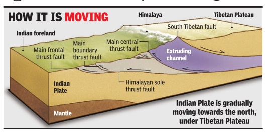
The Indian plate, which is part of the Indo-Australian plate, is moving in a north-north-east direction and colliding with the Eurasian plate. The Himalayas came up as a result of this movement.The collision has resulted in the formation of many fault lines along the region, which has made it highly susceptible to earthquakes.
Most susceptible regions to earthquakes
The Pacific `Ring of Fire', a horseshoe shaped region encircling the Pacific Ocean, accounts for 90% of all earthquakes. This 40,000 km long stretch has 452 volcanoes and is home to over 75% of the world's volcanoes. The next most active region is the Alpide belt, which lies along Java, Sumatra, the Himalayas, the Mediterranean, and the Atlantic Ocean.
Various seismic zones in India
According to the Indian metrological department, the Bureau of Indian Standards has grouped the country into four seismic zones, from Zone V , the most active, to Zone II, the least active.Zone V consists of parts of Jammu and Kashmir, Himachal Pradesh, Uttarakhand, Rann of Kutch, part of north Bihar and the Andaman & Nicobar Islands. The remaining parts of Jammu & Kashmir and Himachal Pradesh, Delhi, Sikkim, northern Uttar Pradesh, Bihar and West Bengal, parts of Gujarat and small portions of Maharashtra near the west coast and Rajasthan fall under zone IV (severe intensity zone).
History
But nothing has changed since 1993, when a relatively milder earthquake of magnitude 6.4 in Maharashtra's Latur district killed nearly 10,000 people in what was considered a non-seismic zone. Most died because shoddily constructed houses collapsed at the first major shake, as they did in Gujarat eight years later.
The only serious earthquake that modern India remembers is the temblor that killed about 20,000 in Gujarat in 2001. The 2004 tsunami, which resulted from the third-most severe quake ever recorded, 9.3 on the Richter scale, occurred when the Indian plate slid with greater violence than it normally does under the neighbouring Burma plate, upon which rest the Andaman and Nicobar Islands.
It caused a 100-km-long rupture in the crust, thrusting the seafloor upwards and pushing up masses of water, setting off the tsunami that killed 230,000 people in 14 countries.
No Indian metropolis has witnessed a serious earthquake, although Delhi lies in high-risk seismic zone 4. Srinagar and Guwahati are in the highest-risk zone 5, and Mumbai, Chennai and Kolkata lie in zone 3. History serves a warning that a big one may come at any time. Those lessons come from Bihar in 1934 and Assam in 1950.
Although its epicentre was 10 km south of Mount Everest, the Bihar earthquake of 1934 was felt from Mumbai to Lhasa, flattening almost all major buildings in many Bihar districts and damaging many in Calcutta, now Kolkata. At 8.4 on the Richter scale, it was pretty severe, killing more than 8,100 (Mahatma Gandhi said it was punishment for the sin of untouchability).
The 1950 Assam earthquake may have geologically set the stage for a really big one in the Himalayas, according to geologists. Now that 65 years have passed, it may be time for a big one.
(In arrangement with Indiaspend.org)
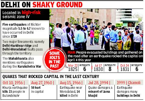
Delhi: located in ‘high-risk’ seismic zone IV
Disaster authority for stricter quake norms
Ambika Pandit TNN
The Times of India 2013/08/06
Delhi is located in the ‘high-risk’ seismic zone IV. The Vulnerability Atlas of India (1997) says for shaking intensity eight, 6.5% houses in Delhi have high damage risk and 85.5% houses have moderate damage risk. “Most buildings may not meet codal requirements on seismic resistance. Disaster prevention involves engineering intervention in buildings and structures to make them strong enough to withstand the impact of natural hazard,” said DDMA divisional commissioner Dharampal.
DDMA has observed that ill-designed high-risk areas and highrises exist in Delhi without specific consideration of earthquake resistance. “Connaught Place, numerous district centres and sprouting highrise group housing schemes are high risk areas due to the vertical development and plan configurations,” DDMA concedes. The Walled City, trans-Yamuna area, and scattered pockets of unplanned settlements also figure as high-risk zones due to their substandard structures and high density.
April 25, 2015: quake in Delhi
The Times of India, Apr 26 2015
Last time city shook so much was 55 years ago
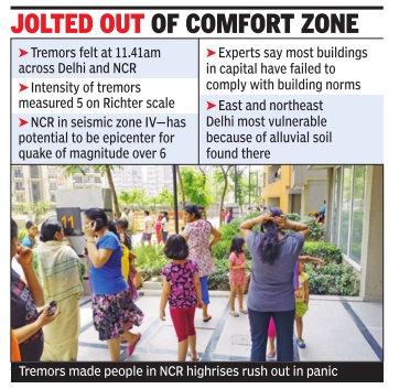
Not since 1960 had the capital shook so much. The earthquake that rattled Delhi just before noon on Saturday was the severest in 55 years, measuring 5 on the Richter scale locally . Although no casualties were reported here, the intensity and duration of the tremors sent people scurrying out of homes and offices.Those who were stuck on high floors froze in panic and prayed with hearts drumming deafeningly . After three seismically quiet years--the last notable quake occurred in Bahadurgarh, 30km from Delhi, on March 5, 2012--the city took a few moments to realize what was happening.
The tremors started at 11.41am and continued for about two minutes. But when they were over, people hesitated to return indoors. Nobody wanted to take a chance and they looked for signs--a suspended bulb or ceiling fan that wasn't swaying. Hardly had they returned indoors when a second wave of tremors struck at 12.18pm. This time, people reacted faster, grabbing their phones and keys and making a dash outdoors. “We were downstairs for about 10 minutes when the first tremors were felt. Just as we thought the worst was over and turned on the TV for news, the tremors started again, said Nitish Saxena, a resident of Mayur Vihar Phase I.
L S Rathore, director of India Meteorological Department, which monitors earthquakes, said a temblor's intensity reduces away from the epicentre. “While the epicentre recorded 7.9 on the Richter Scale, it was about 6.5 in Gorakhpur and about 6 in Lucknow. In Delhi, the intensity was 5. On August 27, 1960, Delhi was shaken up by an earthquake that had its epicentre between Delhi Cantt and Gurgaon. About 75% of the buildings around the epicentre developed cracks and minor damage to Red Fort and Rashtrapati Bhavan was also reported. About 100 people were injured by falling debris and in stampedes. Although the quake was first classified as a magnitude-6, researchers now say it was more likely a magnitude-4.8.
To take stock of the situation, LG Najeeb Jung called a high-level meeting with CM Arvind Kejriwal, police commissioner B S Bassi, the MCD commissioners and other senior officials on Saturday evening. Officials reported hairline cracks in three buildings in the East district, two in the South district and one in North district. PWD officials checked all flyovers and reported them safe.
Delhi lies in `seismic zone IV' or an area of high damage risk from earthquakes. Parts of it lying on the Yamuna floodplains are especially vulnerable. Although earthquakes occur regularly here, most of them cannot be felt, but a magnitude 6 or 7 quake is possible and could cause extensive damage to life and property as, architects and planners say , 95% of the buildings have not been built in accordance with the safety code.Many are not certified by structural engineers and don't have completion certificates from civic agencies.
Geo-tectonic aspect
Indian plate moving under the Tibetian Plateau
The Times of India May 13 2015
More high-intensity quakes likely in region
While opinion is sharply divided over whether May’s temblors were a fresh earthquake or an aftershock of the 7.9 that hit Nepal in April 2015, experts are worried there may be more high-inten sity earthquakes that could af fect the region in the coming few months. Dr A L Ramanathan, pro fessor of environmental geolo gy, JNU, says the Indian plate has been active and release of energy in the form of earth quakes and aftershocks mea suring 6.5 and above on the Richter scale is likely to contin ue over the next few months “The faults in the zone cover ing Afghanistan, Nepal, India and Pakistan have been activa ted. The area from the Hima ayas up to Uttarakhand may experience some activity in the coming months,“ he said.
Dr C S Dubey , professor, de partment of geology , Delhi University, added that while predicting the exact time and location of an earthquake is not possible, there are three seismic gaps where stress has been increasing. “These are between Kashmir and Himachal Pradesh, parts of east Uttarakhand, and between Bhutan and Arunachal Pradesh where a mega earthquake is waiting to happen. In fact, there may be many more mega earthquakes in the Himalayan region,“ he says.
India Meteorological Department says that this quake is an aftershock of the massive one felt on April 26. Dr L S Rathore, DG, Met, said the temblor was centered in the same zone as the previous one and aftershocks can go on for several days. “It is my opinion that this was an aftershock.However, there are two schools of thought. It will take a couple of months to study this and say for sure,“ he said. However, those calling it a fresh earthquake say that it is too big and occurred after too long to be an aftershock.
Devesh K Sinha, head of department (Geology) at DU, says, “Tuesday's quake was 7.3 on the Richter scale, almost as high as the one felt in April.The epicenter of both quakes is also different...this latest one is closer to Mt Everest.This is definitely not an aftershock,“ he said.
So much activity in the earth's crust around Nepal is being caused by the sudden release of energy that has been accumulating for years in the rocks below the surface due to movement of the Indian plate towards the north, under the Eurasian plate.
Dr Saumitra Mukherjee, professor (geology and remote sensing), JNU, explains: “The Indian plate has been moving by 5-6 cm each year towards the Eurasian plate. The movement causes build-up of energy in the rocks. Once the rocks give way , there is an earthquake. In this particular region, the release of energy in the form of an earthquake last occurred some 80 years back. Now, the rocks have no longer been able to retain the pressure and have crumbled, causing the quake.The aftershocks are results of the plates settling down.However, analysis has shown that despite two big earthquakes, all energy has not been released“
2016, Jan: Manipur and Assam/ 6.7 Richter
The Times of IndiaJan 05 2016
Oinam Sunil, K Sarojkumar Sharma &Prabin Kalita
Imphal Guwahati
At least eight people, six in Manipur and two in Assam, were killed and around 90 injured when a magnitude 6.7 earthquake rocked the northeast as well as parts of eastern India a little before dawn on Monday . “A massive temblor jolted people out of their sleep at 4.37am,“ an official in Imphal said. Over 165 houses were damaged in Imphal East, Imphal West, Senapati and Tamenglong districts.
Union home minister Rajnath Singh, who was in Assam to visit the border, said, “I woke up because of a big shake around 4.30am.Later, the PM called me up to know about the situation.“ Manipur CM OkramIbobi Singh said the epicentre of the quake was Noney village in Tamenglong district, about 40km north-west of Imphal.The Manipur capital suffered the most in the earthquake that sparked panic across the northeast.
The CM announced ex gratia of Rs 5 lakh each to families of the dead and said the government would bear treatment cost of the injured. “The Centre has sent a contingent of 65 NDRF personnel and equipment to Manipur. Another NDRF team will reach here on Tuesday ,“ he added.
In Guwahati, people rushed out of their homes in panic. “The ground shook for about a minute. It must be the biggest quake since 1950,“ an elderly resident of Imphal said. “Household objects toppled and almirahs shook,“ Shiva Singh, another Imphal resident, added.
M Angamuthu, deputy commissioner of Assam's Kamrup (Metro) district, said, “Around 15 people were injured in Guwahati while running out to safety.“ He added, “At least 30 buildings developed cracks. The number may go up once we complete assessing of the damage.“
Manipur works minister RatanKhumujam said there were three deaths in Imphal West, two in Imphal East and one in Senapati. In Guwahati, two persons died at densely-populated Maligaon. Scores were injured in Guwahati and Barak valley which is close to Manipur's Tamenglong district.
Officials in Guwahati said many high buildings, including the Gauhati Medical College, Assam Medical College and Hospital in Dibrugarh and Silchar Medical College, developed cracks. Railway tracks in Naharkatiya in Dibrugarh were damaged.
Assam commissioner for disaster management P K Tiwari said the additional district commissioner's office and a fire station in Cachar were damaged. A number of buildings suffered cracks in Assam's Bongaigaon, Chirang, Dibrugarh, Golaghat, Lakhimpur, Morigaon, Nagaon and Sivasagar districts.
In Imphal, a market ex clusively run by women was damaged. The Manipur Press Club building in Imphal developed huge cracks.A road leading to the Leimakhing Army base was damaged in many places.
Earthquakes measuring 8.2+ predicted
The Times of India Jan 06 2016
Pradeep Thakur
`Delhi Also Falls In The Danger Zone'
The Union home ministry's disaster management experts have warned of a bigger catastrophe -earthquakes measuring 8.2 or greater on the Richter scale -in the already ruptured Himalayan region.
They say quakes with a higher intensity than the one that struck Manipur on Monday are likely to rock the region in the future. The tectonic shift a series of recent earthquakes have caused in the region -Manipur, 6.7 (2016), Nepal, 7.3 (2015) and Sikkim, 6.9 (2011) -has again ruptured plates that had already developed cracks during previous temblors. This has led to conditions which might trigger multiple earthquakes with a magnitude of up to 8.0.
In a post-Nepal disaster assessment, the MHA's National Institute of Disaster Management (NIDM) has warned of enhanced risk around the “ring of fire garlanding the entire north India, especially the mountains“. This was also highlighted at a recent meeting organised by the Centre in Arunachal Pradesh capital Itanagar where policymakers from 11 hill states had participated and resolved to develop a common building code for mountains.
Speaking to TOI, NIDM director Santosh Kumar said the interconnected plates across Nepal, Bhutan, Myanmar and India pose a bigger danger, and predicted a disaster of a bigger magnitude that awaits hill states and parts of Bihar, UP and even Delhi, which fall under the second worst seismic classi fication, Zone IV. The NorthEast and other hill states fall under severe seismic Zone V .
Though some Indian scientists have reservations, but international experts, prominently Roger Bilham, the University of Colorado seismologist, are of the opinion that “the current conditions might trigger at least four earthquakes greater than 8.0 in magnitude. And if they delay, the strain accumulated during the centuries provokes more catastrophic mega earthquakes“.
Kumar said the Centre has taken measures to sensitise the governments of all hill states to adopt a common building code different from the rest of India. The Itanagar meet on sustainable development of mountain states were part of Centre's earthquake risk mitigation strategy to sensitise policy-makers about “the natural time bomb“.
Stress has increased in the mountains of northeast since the Nepal quake. Monday's temblor shows the stress has not been fully released, it has only become worse. “The collision between the Himalayan plate in the north and the Indo-Burmese plate in the east, and the risk created as a result, is the highest at this moment,“ according to NIDM experts.
According to MHA's own assessment, the regulatory mechanism in Indian cities that prominently figure on the disaster map are weak, and any disaster in any one would cause huge casualties.
