Gwadar II
This is a collection of articles archived for the excellence of their content. Readers will be able to edit existing articles and post new articles directly |
Gwadar
October 14, 2007
EXCERPT: Discovering Gwadar
By Ihsan H. Nadiem
The book renders a visual description of the the land, history and the people of Balochistan
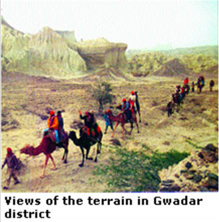
THE district of Gwadar, traditionally a part of Makran, lies in the southern-most part of the Province of Balochistan. It extends over 600 kilometres of coast-line on the Arabian Sea — along its southern limits — and unirrigated and desertic stretches of Kulanch and Dasht Valleys. In its north are situated the districts of Kech and Awaran with Lasbela district in its east. On the western side it shares the international border with Iran.
The district does not boast of its history, which would be independent of the other districts of the region, especially the southern areas of Balochistan. Alexander of Macedonia, while marching through the land on his way back from his adventures in the South Asia subcontinent, is recorded to have found the sea in the areas of this district. The famous Greek historian Arrian mentions it as the country of Ichthyophagoi.
Alexander’s admiral, who was commanding the part of his army destined to take the course of the Sea along the coast, cites the places as Kalmat, Gwadar, Pishukan, Chahbar etc. The post-Alexander history of the region has been touched at different places elsewhere. The area came into the light of history once again during the 16th century AD when the Portuguese found their way to the South Asia subcontinent and captured several places along the Makran coast. Old records reveals that in 1581 they burnt ‘the rich and beautiful city of Pasni’ and Gwadar. Although many invaders conquered this region, yet they did not appear to be interested in staying here any longer to rule it. Perhaps this is why it was mostly the local rulers, including Hots, Rinds, Maliks, Buledies and Gichkis, who exercised their authority here.
Historians recount that there were two regimes of local rulers — Buledies and Gichkis who have left impressions on the region. The Buledies gained power with the rise of the Zikri sect. These rulers are said to be connected with the rulers of Muscat and were so known because of their having belonged to the Valley of Buleda. They are said to have enjoyed power till around the middle of the 18th century. During their final years in power they are said to have abandoned the Zikri sect and embraced Islam.
The other tribe, Gichkis, who themselves Zikri, joined others in their faith but their internal feuds weakened them. Mir Nasir Khan I exercised nine military outings against them ostensibly to eliminate the influence of the Zikri sect.
In the last quarter of the 18th century, Gwadar and the surrounding country fell into the hands of Muscat. The power struggle between the brothers at Muscat resulted in fleeing Sayid Sultan to Makran where he came in contact with Nasir Khan by whom he was well-received. He lived in Gwadar for some time and was then able to capture the Sultanate of Muscat in 1797.
After his death some seven years later, his son lost the rule temporarily to the Buledi chief and Gwadar remained in their possession. It is generally stated that the right of sovereignty in Gwadar was transferred by the Khans of Kalat to Muscat. The people in general believe that the unirrigated tracts of Kulanch and Dasht valleys have always been the parts of Kech.
As already mentioned elsewhere, the first Afghan war (1838-1839) directed attention of the British to the area. Major Goldsmith visited the area in 1861. He was later on — in 1863 — appointed as an Assistant Political Agent in Gwadar. Both Pasni and Gwadar remained designated and served as ports of call for the steamers of the British India Steam Navigation Company. The first ever telegraphic link to this area was made in 1863 when Gwadar was linked to Karachi and a telegraph office was also opened at Pasni. Later, post offices were opened at Gwadar in 1894 and at Pasni in 1903. Ormara was linked telegraphically in 1904.
After independence from the British, all the areas except Gwadar and its surroundings joined the Balochistan States Union, as part of Makran State. In October 1955, Makran was given the status of a district of former West Pakistan province after its accession to Pakistan. In 1958, the Gwadar region was reverted from Muscat to Pakistan and was made a tehsil of Makran district.
On July 1, 1970, when one unit of the West Pakistan Province was dissolved and Balochistan gained the status of a province, Makran became one of its eight districts. On July 1, 1977, Makran was declared a division and was divided into three districts, named Panjgur, Turbat (renamed Kech) and Gwadar.
Some remains of old forts are still visible within and around the Gwadar town, which in itself has now attained great importance because of its strategic location at the Gulf of Oman after the development of the Pakistan deep-sea port.
The pace of work to develop Gwadar picked up some years ago and it now stands connected to important cities like Karachi, Quetta and others not only within the country but to places as far as China and the Central Asia. The Coastal Highway, the drive on which is a real treat, meanders through plains, hillocks, desert, and along the sea coast, hence the name. The driving distance from Karachi to Gwadar is around 650 kilometres; the initial 100 kilometres are covered through the RCD Highway while taking the Coastal Highway beyond Uthal, the district headquarters of Lasbela. While driving from Karachi the main cities that one gets to see along the way are Ormara that has a naval base, and Pasni.
Gwadar town had long remained a small fishing village before it came to prominence, mainly because of its natural location. There are remains of Portuguese forts and those of the British colonial periods, where foreign powers had a presence till the withdrawal of forces from the east of Suez in the late 1960s.
In addition to the most modern network of roads Gwadar also is connected to other parts of the country with air service. The present airport, which is quite small, is the legacy of the British era and had started functioning back in 1920s when the first flight landed here. However, the construction of a new airport to provide all the facilities to the travelling public and the merchants of the area is very much in the offing.
Excerpted with permission from
Balochistan: Land, history, people
By Ihsan H. Nadiem
Sang-e-Meel Publications, Lahore
ISBN 969-35-2023-8
160pp. Rs1,600


