Satellites: India

This is a collection of articles archived for the excellence of their content. Readers will be able to edit existing articles and post new articles directly |
The broad picture
1999-2019: 300 satellites from 33 nations put in space
U Tejonmayam, Nov 28, 2019: The Times of India
Key Highlights
Isro, successfully launched PSLV-C47 that placed Earth observation satellite Cartosat-3 and 13 US nanosatellites
It marked Isro's milestone of launching more than 300 satellites from 33 countries in two decades
The 1,625kg Cartosat-3 is the first in the third-generation Earth observation satellite with a high-resolution imaging capability
SRIHARIKOTA: Two months after lunar lander Vikram's failure to softland on Moon, cheer was back at Indian Space Research Organisation (Isro) when it successfully launched PSLV-C47 that placed Earth observation satellite Cartosat-3 and 13 US nanosatellites. It marked Isro's milestone of launching more than 300 satellites from 33 countries in two decades.
"I heartily congratulate the entire @isro team on yet another successful launch of PSLV-C47 carrying indigenous Cartosat-3 satellite and over a dozen nano satellites of USA. The advanced Cartosat-3 will augment our high resolution imaging capability. ISRO has once again made the nation proud!," tweeted Prime Minister Narendra Modi.
Around 17 minutes after the rocket lifted off from the second launch pad at Satish Dhawan Space Centre, Sriharikota, the launcher injected Cartosat-3 into a 509km polar sun-synchronous orbit. In the next 10 minutes, 13 nanosatellites from the US were placed in their respective orbits.
The 1,625kg Cartosat-3 is the first in the third-generation Earth observation satellite with a high-resolution imaging capability and the ninth in the Cartosat series. Isro chairman K Sivan said, "Cartosat-3 is the most complex and advanced earth observation satellite developed by Isro so far."
The camera on board the satellite is expected to capture images with a spatial resolution of less than 30cm (which means from space it can see objects as small as 30cm). Cartosat-1 had 2.5m resolution and the Cartosat-2 series had 1m resolution. Isro said Cartosat-3 would help large-scale urban planning, rural resource management and infrastructure development, besides providing information for coastal land use and land cover.
For Isro, this is the 47th successful PSLV flight since its first success on October 15, 1994, when the vehicle, in its second development flight placed 804kg remote sensing satellite IRS-P2 in orbit. So far, PSLV has placed 48 satellites including Chandrayaan, Mars Orbiter Mission and micro, nano and experimental satellites.
It was the fifth launch of the year that comes after GSLV-MkIII successfully launched Chandrayaan-2 in July 22. In September, Vikram lander crashed when it attempted to softland on Moon. Isro has so far placed 310 satellites from 33 countries since May 26, 1999 when PSLV, on its second operational flight, carried three satellites in a single vehicle for the first time which included those from Korea and Germany.
Sivan said the agency has planned 13 missions in the next four months which includes six launch vehicle missions and seven satellite missions. "Our hands are full. Team Isro will rise to the occasion and meet every demand," he said.
Aryabhata: India’s first satellite into space
India Today.in , Once an astronomer, then a satellite “India Today” 15/12/2016
1975
Aryabhata
Once an astronomer, then a satellite
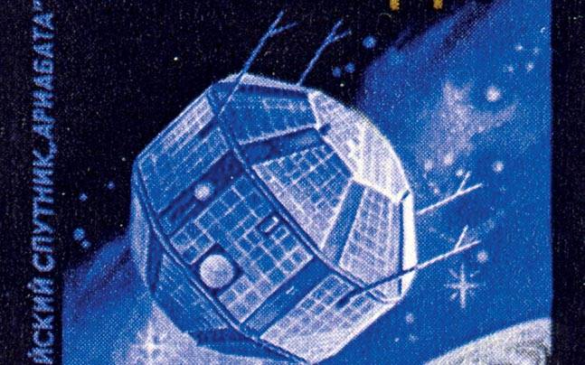
India launched its first satellite into space on April 19, 1975. Named after the ancient Indian astronomer, Aryabhata was constructed by the Indian Space Research Organisation (ISRO) and rode into space aboard a Kosmos-3M launch vehicle from Kapustin Yar, the then Soviet Union's rocket launch and development site. It was constructed with the aim of gaining experience in building and operating satellites, but was also equipped with a suite of instruments to conduct experiments in x-ray astronomy and solar physics, among others. Aryabhata was designed as a 26-sided polyhedron, with a diameter of just over four-and-a-half feet, and was powered by solar panels, which were laid over 24 of the 26 sides of the satellite. Unfortunately, Aryabhata's mission was shortlived-a power failure caused the mission to end after four days, after the satellite had completed just 60 orbits of the Earth.
A-SAT
2019: The highlights
Chethan Kumar & Rajat Pandit, INDIA SHOOTS INTO STAR WARS CLUB, March 28, 2019: The Times of India
RACING AHEAD: In Display Of ‘Shakti’, Is 4th Nation To Test Anti-Sat Weapon After Russia, America, China
Capability Existed Since At Least 2012, Modi Gave Nod 2 Years Ago
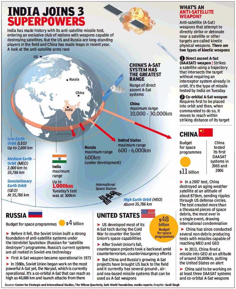
India successfully tested an anti-satellite missile to destroy an orbiting satellite at an altitude of almost 300km on Wednesday, jettisoning its long-standing reluctance to flex military muscle in space. It thus became the latest to conduct the test after China in 2007 and joined an exclusive club of the US, Russia and China.
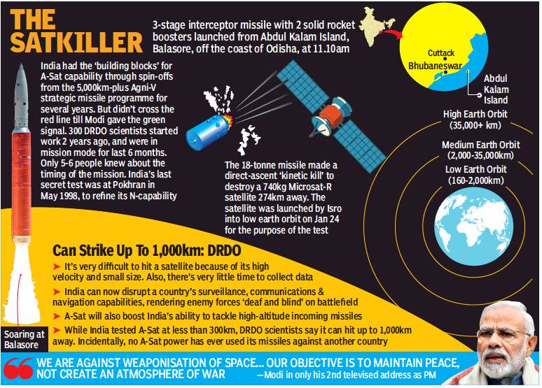
India test-fired the threestage interceptor missile from APJ Abdul Kalam Island off Odisha coast at 11.10am. About 70 minutes later, PM Narendra Modi announced the success of ‘Mission Shakti’ in a televised address to the nation.
The 18-tonne missile, with two solid rocket boosters, tore into space to hit the 740-kg satellite, flying in a low earth orbit (LEO), bang in the middle, barely three minutes after its launch over the Bay of Bengal.
Defence Research and Development Organisation chief Satheesh Reddy told TOI that while work on the ballistic missile defence (BMD) programme was going on for years, “the project only got the official goahead about two years ago. And we got into mission mode only six months ago”.
Reddy also said all technologies for the A-Sat mission were developed indigenously. “In the A-Sat test, we achieved an accuracy of a few centimetres, meeting all technical parameters and objectives. We have the capability to do it at much higher altitudes but conducted the test in LEO or lower atmosphere to ensure the space debris decays and falls back to earth,” he said.
A top defence scientist added, “The mission was a direct-ascent kinetic kill. The relative velocity between the missile and the orbiting Microsat-R satellite, which was launched by Isro on January 24 for the test, was around 10km per second.”
The launch, about two weeks ahead of the first round of polling in Lok Sabha elections, was read by political circles as likely to reinforce the tough on national security image of BJP and Modi after the air strikes on a Jaish-e-Muhammed terror camp in Balakot.
Missile can go up to 1,000km if required, say scientists
PM Modi’s decision to address the nation almost immediately after the successful completion of Mission Shakti sparked a fresh political fight with some opposition parties claiming it was a violation of the model code of conduct and Congress chief Rahul Gandhi praising DRDO scientists but slamming the PM for “political theatre”.
Government sources said the significance and international ramifications of the missile launch required the PM’s “authority and credibility” to assure that India’s objectives were peaceful and defensive and did not violate international commitments. This task could not be left to an official and needed the PM to explain the test’s ramifications.
The strategic significance of the ‘satellite killer’ missile is considerable as it gives India the capacity to match China’s ability to strike down ‘enemy’ satellites. Though China achieved this capacity 12 years ago and has made big strides in the field, Wednesday’s test gives India the technological competence to target satellites, knocking out an adversary’s eyes and ears in space.
Though the A-Sat missile was tested for a 300km altitude, DRDO scientists are confident it “can go up to 1,000km” if required. “We need the capability to neutralise surveillance, communication, navigation and other military satellites during a conflict to render enemy forces deaf and blind,” a defence source said.
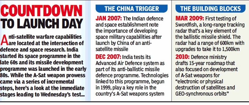
India is worried about the huge strides made in the military space arena by China, which tested its first A-Sat missile in January 2007 and also has robust programmes for kinetic and directed-energy laser weapons as well as nano-satellites.
With the test, India had become the fourth country to acquire this “global space power” status.
Successful test of anti-satellite missile
From: Chethan Kumar & Rajat Pandit, INDIA SHOOTS INTO STAR WARS CLUB, March 28, 2019: The Times of India

From: March 28, 2019: The Times of India
See graphics:
The anti-satellite missile
A-SAT, 2019: the essential facts
Timeline: 2007-17
From: March 28, 2019: The Times of India

From: March 28, 2019: The Times of India
See graphic:
The A-SAT launch: a timeline: 2007-10
The A-SAT launch: a timeline: 2013-17
The Secret Mission
Chethan Kumar, How A Secret Mission Launched Satkiller, March 28, 2019: The Times of India
Only 5-6 People Knew About Timing Of Test
The test to “kill” a satellite accomplished on Wednesday was a technologically complex mission that synced a host of sophisticated systems even as the mission was kept a tightly guarded secret known only to a small group right up to the day of the launch.
“Typically, we get about less than one second to intercept a satellite given its velocity. To overcome this challenge, a host of technologies go into guidance control, mission computer, systems that aid accuracy and relative timing,” DRDO chief Satheesh Reddy told TOI, without elaborating on the specific technologies or the budget.
Former DRDO chief Avinash Chander, who helped develop India’s missile capabilities, said Wednesday’s mission could be seen as an extension of DRDO’s long-range anti-ballistic missile programme. However, he pointed out that the “satellite killer” project was initiated recently and was significantly different.
“The satellite is a different ball game given that the velocity is much higher, the size is small and you have a very short time to collect data. You need appropriate booster vehicles that give sufficient velocity to reach a target in the given time, and you must have an anti-satellite vehicle that tracks the satellite and corrects the distance. You will only have 10-15 seconds to do this,” Chander said.
The test demonstrated India’s capability to defend its assets in outer space, with the anti-satellite missile seen as being a major deterrent in a conflict.
Scientists explained that these capabilities were also seen to add to the country’s abilities to tackle high-altitude incoming missiles. India has a long-standing ballistic missile defence (BMD) programme with multiple missiles already in its arsenal.
“As of today, those missiles cannot intercept a target at such altitudes. The Asat, in that sense, is a game changer that can help our forces tackle incoming missiles at a greater height,” a scientist said.
Reddy said 300 DRDO scientists and staff worked on the project day and night over the past six months and yet its scope and objectives were kept under wraps. “Even as of yesterday (Tuesday) evening, not more than five-six people knew about the test today (Wednesday),” he said.
The last time India carried out a secret test was in May 1998, when it tested nuclear weapons in Pokhran. Incidentally, the test laid the foundation for India’s ballistic missile programme, which is today pegged as one of the best in the world.
What is an anti-satellite weapon?
From: March 28, 2019: The Times of India
See graphic:
Anti-satellite weapons in India, USA, Russia and China/ As in 2019
2019: India vis-à-vis China
Rajat Pandit, A big leap, but India still miles behind China, March 28, 2019: The Times of India
India’s first-ever anti-satellite missile test was in direct response to rapid advances made in the military space arena by China, which has had “counter-space” capabilities as a thrust area and tested its own A-Sat weapon against a “lowearth orbit (LEO)” weather satellite in January 2007.
While improving upon its already extensive space-based intelligence and reconnaissance abilities, the People’s Liberation Army also has several projects underway for strong counter-space capabilities ranging from “direct-ascent kinetic kill missiles” to directed-energy laser weapons and satellite jammers to destroy or degrade an adversary’s space assets during a conflict.
Having set up a dedicated Strategic Support Force four years ago to handle space and cyberspace operations, China is moving towards a space station with military applications in the near future.
India, in sharp contrast, has not even approved a full-fledged Aerospace Command that the armed forces have been demanding for almost a decade now. The PM Narendra Modi government only recently agreed to set up a small tri-Service Defence Space Agency.
“This has to change now. India cannot keep on missing the bus. We should have the capability to counter China and its rapidly expanding A-Sat capabilities, multiple military satellites, launch-on-demand nanosatellites and the like. Space and cyberspace, after all, are now the fourth and fifth dimensions of modern warfare after the traditional domains of land, air and sea,” an official said. Effective A-Sat weapons can “blind and deafen” an adversary’s military forces by taking out satellites vital for surveillance, missile early-warning, precision-targeting and other such purposes.
There are an estimated 320 military satellites orbiting the Earth with the US leading the pack with over 140 followed by Russia (80) and China (35). India has only two dedicated military satellites in the shape of the naval GSAT-7 and the IAF’s GSAT-7A, though it also uses “dual-use” remote sensing ones for military purposes.
Despite having an enviable civilian space programme, India has been hesitant about militarising the final frontier.
In 2010, the defence ministry had come out with a 15-year ‘Technology Perspective and Capability Roadmap’ that dwelt on the need to develop ASat weapons “for electronic or physical destruction of satellites in both LEO (2,000km above earth’s surface) and GEO-synchronous orbits”.
But these parts were quietly deleted in subsequent roadmaps. Similarly, though the “building blocks” for development of A-Sat capabilities were present in spin-offs from the Agni-V missile and ballistic missile plans, the option to test a satellite-killing missile was never exercised before.
Cartosat
Cartosat-3 successfully placed in orbit
U Tejonmayam, Nov 27, 2019: The Times of India
From: U Tejonmayam, Nov 27, 2019: The Times of India

From: U Tejonmayam, Nov 27, 2019: The Times of India
SRIHARIKOTA: With the successful launch of Cartosat-3 onboard PSLV-C47 on Wednesday morning, the Indian Space Research Organisation (Isro) has added one more to its constellation of remote sensing satellites that can map the earth with better accuracy. Isro has so far launched eight Cartosat satellites since 2005.
Along with Cartosat, PSLV, in its 49th flight, also placed 13 nanosatellites from the US in their orbits. With this, Isro has launched a total of 310 foreign satellites.
PSLV-C47 carrying Cartosat-3 and the nanosatellites lifted off from the second launch pad at Satish Dhawan Space Centre in Sriharikota at 9.28am, as scheduled. Around 17 minutes later, the rocket placed Cartosat-3 in a polar sun synchronous orbit. The nanosatellites were placed in their orbits in the next 10 minutes.
Isro chairman K Sivan said the launch vehicle precisely injected Cartosat-3 and 13 US nanosatellites into the desired orbits. “Cartosat-3 is the most complex and advanced earth observation satellite developed by Isro so far,” he said.
Cartosat-3 will circle the earth at a 509km altitude with an inclination of 97.5 degrees.
It is Isro's fifth launch in 2019, which included Chandrayaan-2 in July. It is the 21st flight of PSLV with an XL variant and the 74th mission from the Sriharikota spaceport.
Sivan said thirteen missions have been planned till March which includes six launch vehicle missions and seven satellite missions. “Our hands are full. The Isro team will rise to the occasion and meet every demand," he said.
Director of U R Rao Satellite Centre (URSC) P Kunhikrishnan said Vikram processor developed by Isro had been integrated into the navigation system of the launch vehicle and used for the first time.
Cartosat-3
Cartosat-3, the ninth in the Cartosat series, is the first of the third-generation agile advanced earth observation satellites having high resolution imaging capability.
According to the space agency, the satellite shall address the increased user demands for large scale urban planning, rural resource and infrastructure development, coastal land use and land cover and others. The satellite is expected to help in military reconnaissance and mapping.
While Isro has not revealed the specifications of the imagers onboard the satellite, it is expected to have a spatial resolution of less than 30cm, which is far better than that of its predecessors -- Cartosat-1 with 2.5m resolution and Cartosat-2 series with less than 1m resolution. With a resolution of less than 30cm, the cameras onboard Cartosat-3 could capture images with greater accuracy that could help urban planners go as far as taking a headcount of pedestrians at a busy junction.
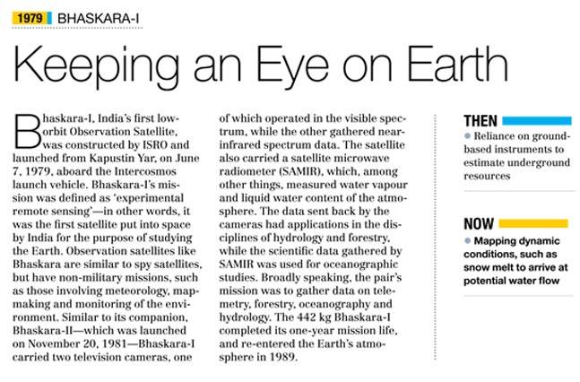
Bhaskara-I: India’s first low orbit Obsevation Satellite
India Today.in , Keeping an eye on earth “India Today” 15/12/2016
See graphic:
Bhaskara-I , India Today
Chandrayaan-1:India’s first unmanned space mission
India Today.in , To put a man on the moon “India Today” 15/12/2016
2008
Chandrayaan-1
To put a man on the moon
India's space programme came of age in 2008, with the first unmanned space mission, Chandrayaan-1, reaching the moon. It included a lunar orbiter and an impactor, and was launched by a modified version of the PSLV on October 22, from the Satish Dhawan Space Centre, the spaceport at Sriharikota, Andhra Pradesh. It attained lunar orbit on November 8. The goals of the mission included high-resolution mapping of the moon in visible, near infrared, low energy X-ray and high-energy X-ray spectra, and the preparation of a three-dimensional atlas of regions of scientific interest. For this, Chandrayaan-1 carried six indigenous Indian scientific instruments, as well as two from the National Aeronautics and Space Administration (NASA), three instruments from the European Space Agency and another from the Bulgarian Academy of Sciences. This mission gave momentum to plans for a modified GSLV for India's proposed manned mission.
China vis-à-vis India: capacities
As in 2019 Mar
Chethan Kumar, March 29, 2019: The Times of India
On March 27, India joined China in an elite club of nations that have the capability to destroy satellites—although no country with the ability has ever hit assets of other nations—the operation, code-named Mission Shakti was a demonstration of India's military power. TOI takes a look at how the space programmes of both countries match up.
It has already sent people into space, landed payload on the Moon, and by 2022, China hopes to set up a space station of its own, all major strides in space technology. India, on the other hand, announced an ambitious human spaceflight mission on August 15, 2018, and is on its way to put two to three astronauts in space by 2022. Its project (Chandrayaan-2) to land payloads on Moon has been delayed—although Chandrayaan-1 orbited the Moon and sent significant data—and its space agency has no plans of setting up a space station.
China already has mastered the docking technology, funds to prepare for which were only granted to Isro recently, and while the former plans to use its re-usable launch vehicle (RLV) by 2020, India is still conducting experiments with a scaled down version of an RLV, two crucial tests of which are scheduled in 2019.
Also, the northern neighbour is capable of launching way more satellites a year—18 to 20—compared to 8 to 12 by India. And if India boasts of its workhorse PSLV, a class of rockets that’s served the country well, the Chinese have the ‘Long March’ class of launch vehicles which have proven their worth.
|
India |
China | |
|
Space Agency |
Isro established in 1969 |
CNSA set up in 1993 |
|
Launch sites |
One site at Sriharikota with two launch pads |
Four sites |
|
Satellite launches |
8-12 launches a year |
18-20 launches a year |
|
Man in space |
Plans to send astronauts in space by 2022 |
Sent man in space in 2003 |
|
Moon mission |
Chandrayaan-1 orbited the Moon. |
Landed payload on the Moon in 2019 Plans to land man on Moon by 2022 |
|
Space Station |
No plans of setting up a space station |
Plans afoof to set up a space station in 2020 |
|
Mars mission |
Mangalyaan, India’s Mars orbiter was launched in 2013 and has been orbiting Mars since September 2014 |
Yinghuo-1, the first Chinese spacecraft launched in 2011 to orbit Mars failed |
A competitive space buff would probably say that China is way ahead of India, and it probably is, but the ethos of the China National Space Administration (CNSA)-China Aerospace Science and Technology Corporation (CASC), and, the Indian Space Research Organisation (Isro) are very different.
Both are working hard to establish themselves as a space power to reckon with along with the US and Russia, whose space programmes, owing largely to the Cold War had considerable head start.
Different Priorities
Experts say that the Chinese effort is aimed at having in place a strategy that makes it powerful enough to put in place international systems—its proposed space station is one such endeavour—that helps further China’s strategy as opposed to the existing systems that are a result of the US and Soviet or Russian efforts.
India, on the other hand, had has a clear priority that space science must first help its citizens, which is why the focus is on Earth observation and communication. Vikram Sarabhai, the father of Indian space programme had once famously said, “We have no fantasies of landing people on the Moon or studying other planets,” and this was not lack of ambition as much as it was a result of a different vision: Make India self-reliant using space technology.
The vision continues to be reinforced by Isro chairman Sivan K, “We are not competing with any country and that’s never been our priority. If we are in race with anybody it is ourselves and we hope that every year we provide better services to the people of this country. Programmes with societal applications are our top priority, and there’s a lot of work to do.”
Isro, which once depended heavily on foreign help to build and launch its satellites, today helps other countries launch theirs, and is among the favourite agencies for many countries. One major example is the Nasa-Isro Synthetic Aperture Radar (Nisar) project in which Isro is an equal partner with Nasa and not an agency that is seeking the big brother’s help.
But space faring isn’t an easy business today and almost no country that wishes to operate an active space agency can do it without co-operation. Both India and China have a series of space co-operation agreements and US is partner with both.
Now, while both India and China have come a long way—China did start later than India with the CNSA only established in 1993, compared to Isro which was formed in 1969—it is the future that matters. From plans for a space station, to putting an asteroid into the Lunar orbit or creating artificial moons in space that serve as street lights in the night, China’s space programme may appear too ambitious to be feasible, but these big ticket science programmes aren’t the only ones that the CNSA is working on.
Indian space stalwarts though the years
Future Path
The Dragon nation has tens of launches lined up this year: According to researchers from the Observer Research Foundation (ORF) tracking the Chinese space programmes and public statements issued by China, the country had hoped for 40 launches in 2018 and had closed 2017 with 22 successful launches.
Compared to India’s one launch site with two launchpads in Sriharikota, China has four launch sites: Its most active site, the Jiuquan Satellite Launch Center, located in Inner Mongolia; the Taiyuan Satellite Launch Center located in the northeast of the country; Xichang Satellite Launch Center located further south and the newest is the Wencheng Satellite Launch Centre.
India has two launch pads in Sriharikota
India also a good year in 2017 with some high profile achievements like the South Asia Satellite launched on May 5, or the record 104 satellites launch by the PSLV in February. But the total number of missions were just six, of which one was a procured launch. It also saw a PSLV heat shield failure in August.
The next year (2018) too was dull for Isro with a couple of failures, but launch activity picked up from September.
This year, Isro aims at launching 19-22 missions, while it has set a target of 50 successful missions in the next three years. Among the key missions to look for in 2019 will be the Chandrayaan-2, which has been delayed again, Aditya-L1 (India’s solar mission) and two demonstration flights of the SSLV (small satellite launch vehicle).
An ORF study, on the other hand predicts that the capacity of China's launch vehicles has put it in direct competition with the West. It says that China is strategically capturing a major share of the international communications satellites market with agencies like the CGWIC (China Great Wall Industry Corporation) negotiating contracts.
Several developing countries like Nigeria, Venezuela, Sri Lanka and Pakistan, are reported to have given repeat orders. India, however, is not lagging behind here with several countries including the US, UK and France opting Isro to launch their satellites.
While accurate figures of the revenue China has earned through such launches is not available easily, Isro has slowly been increasing its revenue. In the past three years—2015 to 2018—the space agency, through its commercial arm Antrix Corporation Limited, has earned Rs 5,600 crore from marketing products and services, including launching of satellite for customers, predominantly from other countries.
But earnings from satellite launches—an important feather on any space agency’s cap—is still low. “The revenue we earn through foreign satellite launches is only 10% to 20% on average, while more than 75% of our revenue comes from satellite communication business. The remaining comes from other services, with transponder leasing and revenue coming from ground station services abroad,” Antrix Chairman and Managing Director S Rakesh had told TOI. Sivan, however, said that Isro can, as and when there's demand, make PSLV launch vehicles available for Antrix, but the GSLV class of vehicles will be difficult. In September this year, Isro’s PSLV will exclusively launch two UK earth observation satellites.
The revenue we earn through foreign satellite launches is only 10% to 20% on average, while more than 75% of our revenue comes from satellite communication business
The ORF study points out that China further intends to capture a major share of the satellite communication market, while Isro also has been pursuant. “One major advantage India has is security. China is not perceived to be safe by many customers, while we enjoy a much better reception,” one senior Isro scientist said without wanting to be named.
2022: India’s Human Mission & China’s Man-Made Moon
One major project that India will implement in the next few years is the human spaceflight programme (HSP). While a lot of groundwork had been happening for nearly a decade before Prime Minister Narendra Modi gave impetus to the project by officially announcing it during his Independence Day speech last year, a lot has happened thereafter too.
Just weeks after the announcement, the Centre, sticking to its commitment sanctioned a budget of Rs 10,000 crore for the project, which Isro Chairman K Sivan says is enough to send humans to space. From its end, Isro too has made some progress: The space agency has finalised its requirements and submitted documents to the Indian Air Force (IAF), whose Institute of Aerospace Medicine (IAM) will now begin the process of astronaut selection.
Air Commodore Anupam Agarwal, Commandant, IAM, says that the institute will not only select astronauts but also provide basic and some advance training; human engineering of the crew capsule and the habitat module; assessment of cabin air quality and the flight surgeon support.
Besides, Isro plans to have a humanoid—a robot resembling a human—conducting a handful of experiments in space on two occasions before actually sending humans by 2022.
The space agency has already received more than 40 proposals from various research institutes. They will now be evaluated by a committee of experts, which will decide on which of them will finally be conducted in space. While this will be India’s big ticket project, the Chinese are not quiet. Late last year, China’s state media reported the country’s plans to put three man-made moons in space by 2022. The Chinese moons will basically be satellites carrying huge space mirrors, which can reflect the sunlight to the Earth on to pre-decided areas any time of the day. The proposed artificial moons will be in an orbit within 500-km of Earth— similar to the orbit India plans to take its astronauts and bring them back.
Military Satellites
According to an ORF paper on Chinese space strategy and modernisation, China's general silence on its own space programme unfortunately makes speculation a primary source of information, while pointing out how it has largely focused on military needs.
While no comprehensive data on how many operational military satellites China has, the Annual Compendium of Commercial Space Transportation: 2018, says that China launched 14 military satellites in 2017 alone, the highest. Comparatively, India has a total of 13 satellites used by the military for various needs. In what was described as the first major use of the Cartosat family of satellites, the last one (2c) launched in June 2016, sources in Isro said, that the armed forces were aided by high-resolution images for the “surgical strikes” conducted across the line of control (LoC) in September 2016.
Electro-Magnetic Intelligence Satellite
Launched 2019

From: U Tejonmayam, April 2, 2019: The Times of India
Five days after striking down a low earth satellite with an ASat missile, India on Monday launched a satellite that will protect its assets, including fighter jets and spacecraft, by detecting radars in enemy territory.
Electro-Magnetic Intelligence Satellite (Emisat) will intercept radar signals and detect the kind of radar and its location. A radar emits radiowaves in specific frequencies that hit targets and bounce back — telling the radar the nature of the target, its movement and distance.
Emisat is a result of a five-year development jointly by Indian Space Research Organisation (Isro) and Defence Research and Development Organisation (DRDO).
DRDO chief Sateesh Reddy called it a major milestone after A-Sat. “We were able to enhance our capabilities and two successes in a short time,” he said.
Isro’s PSLV-C45 made unique manoeuvres to three different circular orbits to also inject 28 foreign satellites.
The fourth stage (PS4) of the new variant of PSLV, in one of its longest missions lasting 3 hours, will stay alive for the next six months providing a platform for three scientific instruments to collect data in microgravity atmosphere.
Isro chairman K Sivan said that converting PS4 into an orbital platform would be most beneficial for students who can conduct experiments.
Geosynchronous satellites
Rukmini (GSAT-7): India's first military satellite
India's first military satellite successfully launched
Rajat Pandit, TNN | Aug 30, 2013
NEW DELHI: India's first military satellite GSAT-7 or " Rukmini", which will boost the Navy's blue-water combat capabilities with a 2,000-nautical mile footprint over the crucial Indian Ocean Region (IOR), was successfully launched from Kourou Island in French Guiana in the early hours on Friday.
Injected into the "geosynchronous transfer orbit" by European space consortium Arianespace's launch rocket around 2am, GSAT-7 promptly deployed its solar panels to generate 2,900 watt, even as ISRO master control facility at Hassan in Karnataka began acquiring its signals.
The naval communication and surveillance satellite will now undergo "three orbit-raising operations" over the next five days to place it in the geostationary orbit of almost 36,000-km above the equator. Once positioned in its orbital slot of 74 degree East Longitude by September 14, its all-important UHF, S, Ku and C-band transponders will begin beaming signals after they are switched on.
It will then become "a potent force-multiplier", networking all Indian warships, submarines and aircraft with operational centres ashore through high-speed encrypted data-links. This is the first time a high-power UHF (ultra high-frequency) transponder forms part of an Indian communication satellite like INSAT or GSAT.
The Navy has been leasing transponders of domestic and foreign satellites over the years for reconnaissance, navigation, communication and other purposes. Now, it will have a "dedicated" satellite of its own to keep tabs over almost the entire IOR — stretching from the African east coast to Malacca Strait, where China is assiduously expanding its strategic footprint.
From the individual "I see, I kill" operation, the entire Navy will now be "seamlessly" networked to get "a composite, clear picture of all the actors" in the IOR. It will transform from "a platform-centric" Navy to "a network-enabled" force. Shorn of military lingo, this means the ability to detect and share emerging maritime threats "in real-time" so that a counter to "neutralise" them can be swiftly launched, said sources.
The Navy has already tested the "ship-end" for "network-centric operations" through the massive Tropex (theatre-level readiness and operational exercise) manoeuvres, with both the eastern and western fleets accompanied by fighters, spy drones and helicopters out at sea.
India might not want "militarisation of space" but effective use of this final frontier for reconnaissance and communication missions to keep tabs on enemy troop movements, missile silos, airbases and the like across land and maritime borders cannot be overstressed. "Satellites can also help in missile early-warning, delivery of precision-guided munitions and jamming enemy networks," said an official.
- GSAT-7 launched from French Guiana, off Pacific Coast, on Friday morning. Will become fully-operational by mid-September, networking all 140 Indian warships, 14 submarines and 200 aircraft, among other platforms. Its footprint will cover almost the entire IOR.
- Satellite delayed by almost a decade. Absence of operational GSLV to launch the 2.6-tonne satellite a major factor. Overall cost, including manufacture and launch, of GSAT-7 around Rs 950 crore. GSAT-7A for IAF and Army to follow by 2014-15.
- India is a late starter in military space arena despite expansive civil programme. Armed forces forced to depend on civilian "dual-use" satellites or leasing foreign transponders. Government reluctant to approve a full-fledged Aerospace Command.
- Around 300 dedicated or dual-use military satellites currently in orbit, with the US owning 50% of them, followed by Russia and China. Beijing even testing ASAT (anti-satellite) weapons since January 2007, apart from active kinetic and directed-energy laser weapons as well as nano-satellite programmes. Wants space station with military applications by 2020
Geosynchronous Satellite Launch Vehicle
2013
GSLV has had a chequered past
The Times of India 2013/08/20
Arun Ram TNN
India’s efforts to power Geosynchronous Satellite Launch Vehicle with indigenous cryogenic engine continue to be jinxed.
The Indian Space Research Organization (Isro) in Aug 2013 called off the launch of the GSLV-D5 after scientists detected a leak in the second stage liquid propellant tank.
The GSLV-D5 launch is crucial as it would demonstrate the country’s ability to develop and use cryogenic engines that are a requisite for the launch of big telecommunication satellites and Isro’s ambitious projects, including manned missions. PSLVs, which India has mastered, can only carry satellites weighing less than 1,500kg.
History
Postponing GSLV flights at the last moment is not new to the somewhat-jinxed three-stage rocket.
The first mission of this rocket was scrubbed following a technical snag and a fire when the countdown hit the zero mark at Sriharikota 12 years ago on March 30, 2001. The countdown was progressing smoothly, and since it was the maiden flight of a new rocket, foreign countries were keenly watching the mission.
The mood was a mixture of excitement and nervous apprehension, till the countdown hit the zero mark and an Isro official announced ‘fire, fire’ over the public address system and declared that the launch was scrubbed. The rocket was back on the launchpad within two weeks and was launched on April 18, 2001. It was only a partial success because the satellite, GSat-1, failed to achieve its orbit. The postponement of the launch on Monday has also raised serious questions about the schedule of India’s second lunar mission, Chandryaan-2, which will use this rocket. Provisionally, it is slated for lift off in 2016.
If this rocket had maintained a good track record, India would not have depended upon Arianespace to launch its two to 2.5-tonne communication satellites. Of the seven flights between 2001 and 2010, only two have been fully successful.
GSLV-D5
India Today.in , This is rocket science “India Today” 15/12/2016
2014
GSLV-D5
Rocket science poses extraordinary challenges. An example is that it took exactly 25 years for India, after developing a rocket that could lob a satellite successfully into orbit, to develop an indigenous cryogenic engine. On January 5, the GSLV-D 5 rocket, which launched the GSAT-14 communications satellite, was powered for the first time by an Indian-made liquid fuelled cryogenic engine. It is a rocket engine that uses a cryogenic, or super-cooled, fuel or oxidiser, which are gases liquefied and stored at very low temperatures. These are super-cooled, comparatively lighter engines than those which use solid fuel propellant, allowing heavier payloads to be delivered into high geostationary orbits or farther into space. In fact, engines such as these were one of the main factors in NASA's success in reaching moon on the Saturn V rocket. When it comes to India, ISRO scientists and engineers, after beginning work at the Liquid Propulsion Systems Centre at Mahendragiri in Tamil Nadu, spent more than two decades developing cryogenic engineering technology.
2015: Indigenous cryogenic engine
The Times of India, Aug 28 2015
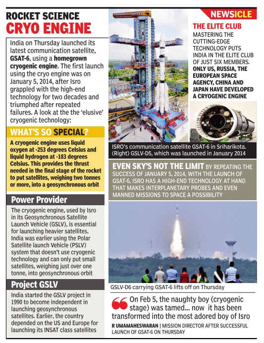
India exercises cryogenic ghost with successful GSLV-D6 lift-off
Arun Ram & Janani Sampath
On January 5, 2014, when Indian Space Research Organisation (Isro) launched GSAT-14 using its Geosynchronous Satellite Launch Vehicle (GSLV-D5), the score card of its success using an indigenous cryogenic engine read: 1-1.
Isro broke the tie in style, clearing all doubts on its cryogenic capabilities by successfully firing GSLV-D6 carrying GSAT-6 into orbit. The first launch using an indigenous cryogenic engine, on April 15, 2010, was a failure.
GSLV-D6 lifted off from the Sriharikota spaceport at 4.52pm. About 17 minutes later, the rocket injected the 2,117kg satellite into a geosynchronous transfer orbit.“This shows that our previous success was not a fluke,“ said Isro chairman A S Kiran Kumar. He wasn't, however, exulting when he added: “We have understood the intricacies of a cryogenic engine. If we don't make errors, GSLV will be a good candidate for commercial launches.“
What went unelaborated were the military capabilities of the communication satellite (used also for television, telephone, radio and internet) with S-band and C-band transponders that cover the entire country -and a little beyond its boundaries. Besides the utility of GSAT, scientists were happy about the second consecutive success of the indigenous cryogenic engine. After India used up six of the seven engines bought from Russia, Isro's big missions now rest on the success of its cryogenic capabilities.
All eyes were on the “ador able boy“ (cryogenic engine) as the rocket's second stage burned out after about five minutes of flight. When the cryogenic engine ignited, there was a roaring applause.The next 12 minutes, when the engine propelled the satellite into space, were marked by a calm suspense that ended with the satellite being put into an elliptical geosynchronous transfer orbit.
2018: Gsat 11, India’s heaviest satellite
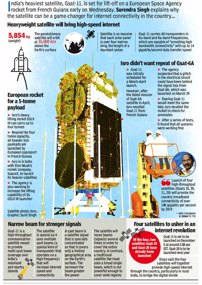
From: December 4, 2018: The Times of India
See graphic:
Gsat 11, India’s heaviest satellite
Pakistan mapped by Indian satellites
2019: 87% of Pakistan’s land area
Chethan Kumar, February 28, 2019: The Times of India
From: Chethan Kumar, February 28, 2019: The Times of India
From: Chethan Kumar, February 28, 2019: The Times of India

From: Chethan Kumar, February 28, 2019: The Times of India
From: Chethan Kumar, February 28, 2019: The Times of India

From: Chethan Kumar, February 28, 2019: The Times of India
Keeping an eye over Pakistan, Isro's satellites provide vital inputs to the armed forces for operations like the Balakot airstrikes
BENGALURU: That India’s space capabilities allow its armed forces to be more effective in planning is no secret. But here’s the extent of India’s reach: Information accessed from the Indian Space Research Organisation (Isro) shows our satellites keep a watch over the entire Pakistan and provide high definition mapping of 87% of the neighbour’s land area, providing vital inputs to the armed forces’ operations like the Balakot airstrikes on Tuesday. Indian satellites are able to map all terrains across 7.7lakh sqkm of Pakistan’s total 8.8 lakh sqkm of land area, giving Indian commanders access to high resolution images of 0.65 metre.
India has similar capabilities for other neighbouring nations — our satellites can map about 5.5 million sqkm of land spread across 14 countries — but details about China were not immediately available. “This coverage is just from the Cartosat family of satellites. There are an array of services that Isro provides, but we cannot comment on everything in public,” a source said.
On January 17, junior space minister Jitendra Singh said that India can peep into Pakistan homes, and it appears he wasn’t joking. “India’s integrated border management system allows India to look into the verandahs and rooms of houses of people across the border in Pakistan,” he said.
The Indian Air Force (IAF), which has a demand for more satellites is happy with the services being provided by Isro. On a specific question, an Air Marshal commanding a top facility said last week: “Do we need more satellites? Yes. But nearly 70% of our demand has already been met and we are on track.”
SENTINEL IN THE SKY
The use of space technology by the Indian armed forces has increased over the years. India has at least 10 satellites for military purpose. The data sent to the military is supplied by Isro's National Remote Sensing Centre in Hyderabad, while data from communication satellites is accessed directly by the end-users
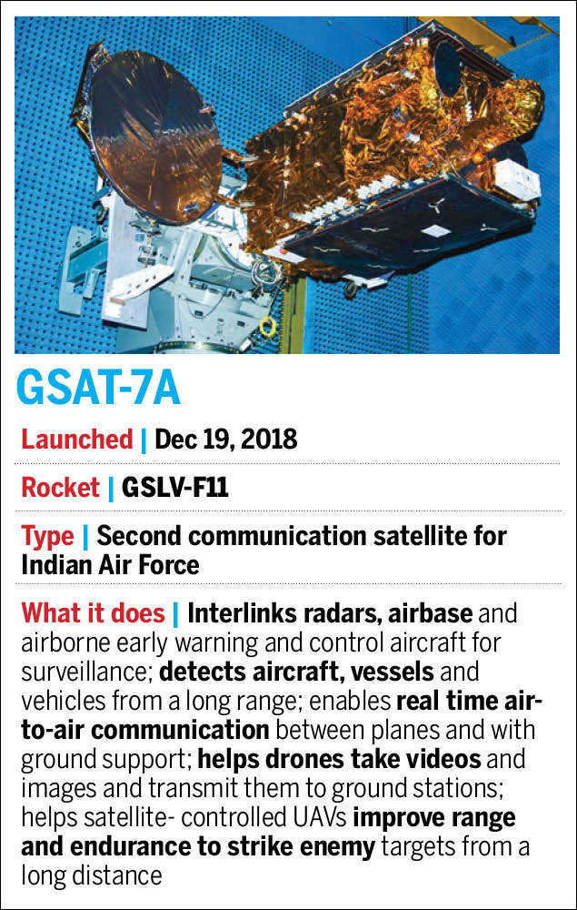
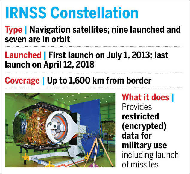
Among the major satellites that have helped the Indian armed forces are the series of Cartosat satellites, GSAT-7 and GSAT-7A, Indian Regional Navigation Satellite System (IRNSS) constellation, the Microsat, Risat and the HysIS (Hyper-spectral Imaging Satellite). If we count individual spacecraft, then more than 10 operational satellites are of use to the military.
As reported by TOI first, the first major use of the Cartosat family of satellites had, in fact, aided India’s surgical strikes across the Line of Control (LoC) in September 2016. Isro has been providing images to the armed forces, the Army in particular.
Cartosat provides ‘area of interest’ (AOI) images based on specific requests. Isro has the capability of providing one or more scenes/images covering the AOI as specified in a single polygon (all the areas in one circle) in the form of a shapefile (non-topological geometry and attribute information for the spatial features).
According to the National Remote Sensing Centre (NRSC) in Hyderabad, AOI products are of two types — standard and precision-based ortho (where images taken from space are corrected to have a uniform scale) — both of which are useful for the armed forces. Ortho rectified products are corrected for terrain distortions and camera tilt effects.
While the first Cartosat was launched in 2005, Cartosat-2A launched in 2007 was the first dual-use satellite with capabilities of monitoring missile launches in India’s neighbourhood. Cartosat-2C, launched in June 2016, can record videos of sensitive targets from space, compress them, and relay to earth. The next in the series, Cartosat-2E, was launched in June 2017. Isro launched a bevy of other satellites for military use in 2018 too.
Polar Satellite Launch Vehicle
2019/ PSLVC44 lifted off at midnight
U Tejonmayam, Here’s why this PSLV lifted off at midnight, January 25, 2019: The Times of India
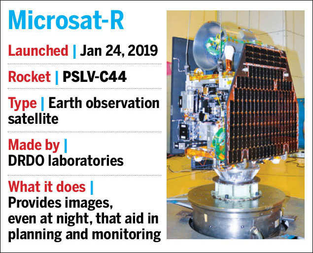
As PSLV lifted off from Satish Dhawan Space Centre in Sriharikota soaring through the night skies for the second time in five months, Microsat-R, the main payload, played a key role in deciding the launch time. The 740kg imaging satellite was programmed to cross the equator every day around noon local time when the sun illuminates the Indian region. At 11.37pm on Thursday, PSLVC44 lifted off with Microsat-R and Kalamsat from the first launch pad in the Indian spaceport at Sriharikota.
“Launch time depends on the requirement of the satellite. Here, they wanted the satellite to cross south to north of equator around noon, maybe due to sunlight condition. Our launcher goes from north to south of equator. To meet the requirement of the satellite, we needed to have a night launch,” said K Sivan, Isro chairman. “It is the satellite team that decides when they want the satellite payload to take photographs. It could be during maximum sunlight condition or minimum cloud condition. Launch time depends on that.”
Private sector satellites
IRNSS-1H to have replaced Faulty Atomic Clocks
Surendra Singh & Chethan Kumar, August 31, 2017: The Times of India
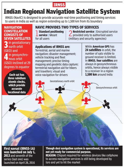
The launch of India's eighth navigation satellite, IRNSS1H, on [31 Aug 2017 was to have opened] a new chapter in the country's history of space exploration as, for the first time, the private sector has been actively involved in assembling and testing of a satellite. [The launch was unsuccessful.] Earlier, the private sector's role was limited only to supplying components.
The 1,425-kg satellite [was] all set to start its voyage from the second launch pad of the Satish Dhawan Space Centre at Sriharikota, riding the Indian Space Research Organisation's trusted launch vehicle PSLV-XL. A consortium led by Bengaluru-based Alpha Design Technologies successfully completed 25% of the development work of IRNSS-1H, under the guidance of Isro scientists.
Isro chairman A S Kiran Kumar told TOI, “For the first time, a private company has been involved in the integration of a satellite. Progressively, we will involve more and more companies in satellite assembly activities.“ Kiran Kumar said, “Subsystems of the payload and launch vehicle are already being developed in collaboration with the industry .“
Alpha Design CMD HS Shankar said the consortium had bagged the orders to build IRNSS-1I and work had already begun. The launch of IRNSS-1I is scheduled for April 2018. Incidentally , in another first, a crucial part of the development of IRNSS-1H happened at the newly developed Isro space park in Whitefield.
Isro felt the need to launch IRNSS-1H after three atomic clocks of its first navigational satellite IRNSS-1A, launched in 2013, stopped functioning.These rubidium atomic clocks, which are imported from European aerospace manufacturer Astrium, are meant to provide accurate locational data.
Tapan Misra, director of Ahmedabad-based Space Applications Centre, said, “We need to know the position of a satellite in order to find the position of an object on earth.And to find a satellite's position, we have to measure it with the help of time. To find the satellite's position with an accuracy of 0.5 metre, atomic clocks are therefore used for precise timing.“ When the time signal is missing, getting true positional accuracy be comes a problem. “Poor the accuracy of these atomic clocks, less the accuracy of the distance calculated.“
Isro had imported 27 sophisticated timekeepers for the nine satellites of the Rs 1,420-crore Indian Regional Navigation Satellite System (operational name NaVIC -Navigation with Indian Constellation). Out of which, seven of the satellites are in the orbit. NaVIC, which has become operational but is yet to be commercialised, has several key applications. It can help merchant ships navigate to their destination, help in real-time tracking of train movements, help government agencies manage resources efficiently using geotagging techniques, help provide location-based services to people and can be used by fishermen reach potential fishing zones at sea.
The satellite will be launched into a sub geosynchronous transfer orbit. After injection into this preliminary orbit, two solar panels of IRNSS-1H will be automatically deployed, and the master control facility at Hassan will perform orbit raising manoeuvres of the satellite.
Satellite TV
India Today.in , A SITE for sore eyes “India Today” 15/12/2016
1975
Satellite TV
A SITE for sore eyes
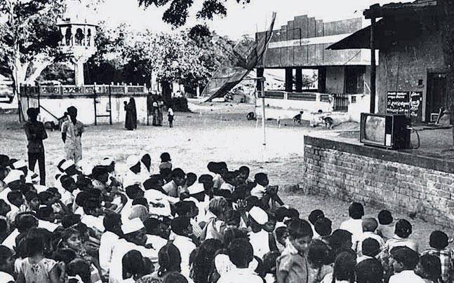
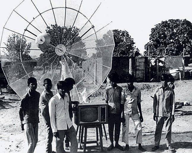
The Satellite Instructional Television Experiment (SITE) began on August 1 in that year. For the first time, 2,400 black-and-white community TV sets came alive in as many villages, clustered in six states across the country. This was long before urban India, including the metros, experienced television. The project, undertaken by ISRO, was designed and implemented in collaboration with the National Aeronautics and Space Administration (NASA) of the United States. This was one of the largest experiments of its kind, with the aim of demonstrating the potential of satellite technology as an effective medium of mass communication for a developing country. Educational programmes made in India were beamed by the Application Technology Satellite (ATS-6) of the US. The year-long SITE project established that the extension of communications infrastructure to remote areas was not only feasible, but that it could also make a contribution to promoting national development.
See also
Indian Space Research Organisation (ISRO)
Satellites: India
