Nagpur Division
(Created page with "=Nagpur Division, 1908= Southern Division of the Central Provinces, extending from 18° 42' to 22° 24' N. and from 78° 3' to 81° 3' E. It consists of a large plain lying...") |
(→Nagpur Division, 1908) |
||
| Line 8: | Line 8: | ||
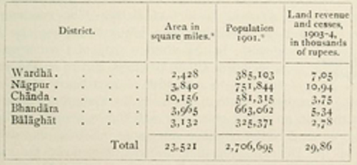
The Nagpur Division includes five Districts, as shown below : — | The Nagpur Division includes five Districts, as shown below : — | ||
[[File: nagpur division.png||frame|500px]] | [[File: nagpur division.png||frame|500px]] | ||
| − | * The District figures of area and population have been adjusted to allow for | + | *The District figures of area and population have been adjusted to allow for |
some changes of territory vhich have taken place since the Census of igoi, | some changes of territory vhich have taken place since the Census of igoi, | ||
including the projected transfer of part of Chanda District, with an area of | including the projected transfer of part of Chanda District, with an area of | ||
Revision as of 07:46, 12 March 2015
Nagpur Division, 1908
Southern Division of the Central Provinces, extending from 18° 42' to 22° 24' N. and from 78° 3' to 81° 3' E. It consists of a large plain lying along the southern base of the Satpura hill ranges, and comprised in the valleys of the wardha and Wain- ganga rivers, with a long strip of hilly country on the eastern border. The Nagpur Division includes five Districts, as shown below : —
- The District figures of area and population have been adjusted to allow for
some changes of territory vhich have taken place since the Census of igoi, including the projected transfer of part of Chanda District, with an area of 593 square miles, to the Madras Presidency.
Of these, Wardha and Nagpur in the valley of the Wardha river on the west, wilh shallow black soil and a light rainfall, constitute the most important cotton-growing tract in the Province, while Bhandara and parts of Chanda and Balaghat in the valley of the Wainganga have been named the ' lake country ' of Nagpur, owing to the number of fine tanks constructed for the irrigation of rice. To the north of Balaghat and down the eastern side of Chanda stretch lines of hills approaching the Godavari river in the extreme south of the Province. The head-quarters of the Commissioner are at Nagpur City. The population of the Division was 2,758,116 in 1881, and increased to 2,982,539 in 1891, or by 8 per cent., the decade having been generally prosperous. At the Census of 1901 the population had fallen to 2,728,063, or by 8 ½ per cent., the principal losses being in the eastern or rice Districts, which were severely affected by distress or famine in several years, while the population of the western or cotton Districts, which escaped more lightly, remained almost stationary.
In 1 90 1 Hindus numbered nearly 84 per cent, of the total, and Animists 13 per cent., while the followers of other religions included Musalmans (86,931), Jains (6,624), ^^^d Christians (7,113), of whom 3,039 were Europeans and Eurasians. The total area is 23,521 square miles, and the density of population 115 persons per square mile.
The Division contains 24 towns out of the Provincial total of 59, and 7,898 villages. Nagpur city (population, 127,734), the head-quarters of the Central Provinces Administration, is the commercial centre, and Kamptee (38,888) is a cantonment 10 miles from Nagpur. Chanda, Bhandak, and Ramtek contain interesting archaeological remains.
This article has been extracted from THE IMPERIAL GAZETTEER OF INDIA , 1908. OXFORD, AT THE CLARENDON PRESS. |
Note: National, provincial and district boundaries have changed considerably since 1908. Typically, old states, ‘divisions’ and districts have been broken into smaller units, and many tahsils upgraded to districts. Some units have since been renamed. Therefore, this article is being posted mainly for its historical value.
