Assam
This is a collection of articles archived for the excellence of their content. Readers will be able to edit existing articles and post new articles directly |
Contents |
The source of this article
INDIA 2012
A REFERENCE ANNUAL
Compiled by
RESEARCH, REFERENCE AND TRAINING DIVISION
PUBLICATIONS DIVISION
MINISTRY OF INFORMATION AND BROADCASTING
GOVERNMENT OF INDIA
ASSAM
Area : 78,438 sq km Population : 2,66,55,528 (census 2001)
Capital : Dispur
Principal Language : Assamese
HISTORY AND GEOGRAPHY
The word ‘Assam’ as interpreted by some scholars is derived from the Sanskrit word Asoma meaning peerless or unparalleled. But the widely accepted opinion of the academic circles today is that the term has come from the original name of the Ahoms, who ruled the land for about six hundred years prior to its annexation by the British. The races like Austric, Mongolian, Dravidian and Aryan that came to this land long long ago have contributed to its composite culture. Thus Assam has a rich legacy of culture and civilization.
Assam was known as Pragjyotisha or the place of eastern astronomy during the epic period and later named as Kamrupa. The earliest epigraphic reference to the kingdom of Kamrupa is found in the Allahabad pillar inscription of king Samudragupta. Kamrupa is mentioned as a Pratyanta or frontier state outside the Gupta empire but with friendly and subordinate relation to it. Hiuen Tsang, the Chinese scholar pilgrim who visited Kamrupa in about 743 AD on an invitation of its monarch, Kumar Bhaskar Varman, left a record of the kingdom he called Kamolupa. Kamrupa also figured in the writings of the Arabian historian Alberuni in the eleventh century. Thus, from the epic period down to the twelfth century AD, the eastern frontier kingdom was known as Pragjyotisha and Kamrupa and kings called themselves ‘Lords of Pragjyotisha’.
The advent of the Ahoms across the eastern hills in 1228 AD was the turningpoint in Assam history. They ruled Assam nearly for six centuries. The Burmese entered through the eastern borders and overran the territory at a time when court intrigues and dissensions were sapping the vitality of the Ahom royalty. It became a British protectorate in 1826 when the Burmese ceded Assam to the British under the provision of the Treaty of Yandabo.
Assam is the sentinel of north-east India and gateway to the North-Eastern States. The State is close to India's international borders with Bangladesh and Bhutan. Assam is surrounded by Bhutan and Arunachal Pradesh on the north, Manipur, Nagaland and Arunachal Pradesh on the east and Meghalaya, Tripura and Mizoram on the south.
AGRICULTURE
Assam is an agricultural State. Agriculture occupies an important place in the economy of the State. The principal food crop is rice. The cash crops are jute, tea, cotton, oilseeds, sugarcane, potato, etc. Noteworthy horticulture items are orange, banana, pineapple, arecanut, coconut, guava, mango, jackfruit and citrus fruits. The State has an estimated 39.83 lakh hectare gross cropped area of which net area sown is about 27.24 lakh hectare.
FORESTS
Assam is known for her rich forest wealth which constitutes 26.22 per cent of the total forest area.
WILD LIFE
The State has five National Parks and eleven wildlife sanctuaries. The Kaziranga National Park and the Manas Tiger Project (National Park) are internationally famous for the one horned Rhino and Royal Bengal Tiger respectively.
INDUSTRY
Of agriculture-based industries, tea occupies an important place. There are six industrial growth centres in the State and two such centres are being set up at Balipara and Matia. Presently four oil refineries have been working in the State including the one at Digboi. Construction of the Export Promotion Industrial Park (EPIP) at Amingaon near Guwahati is nearing completion. A Software Technology Park will be constructed at Borjhar near Guwahati. A Central Institute for Plastic Engineering Technology (CIPET) has been established at Amingaon near Guwahati. Assam has always enjoyed the highest reputation for her arts and crafts associated with her cottage industries. Cottage industries include handloom, sericulture, cane and bamboo articles, carpentry, brass and bell-metal crafts. Assam produces varieties of silk, Endi, Muga, Tassar, etc. Muga silk is produced only in Assam in the world.
POWER
The major power stations are Chandrapur Thermal Project, Namrup Thermal Project and a few Mobile Gas Turbine Units along with a mini hydro-electric project. Revitalising the Thermal Power Station of Bongaigaon and the on-going Karbi- Langpi Project will boost the power supply in the State.
TRANSPORT
Roads : The total length of roads in the State is 37,515 km which includes 2,836 kms of National Highways. The construction of 160 km of barbed wire fencing and 27 kms of the border road along the Indo-Bangladesh International Border have been completed.
Railways : The length of railway tract in Assam is 2,284.28 kms comprising 1,227.16 kms under broad-gauge and 1,057.12 km under metre-gauge lines.
Aviation: The regular civil air services operate from Lokopriya Gopinath Bordoloi Airport (Guwahati), Salonibari (Tezpur), Mohanbari (Dibrugarh), Kumbhirgram (Silchar), Rawriah (Jorhat) and Silonibari (North Lakhimpur).
FESTIVALS
Assam has an exclusive range of colourful festivals. Bihu is the chief festival celebrated on three occasions. Rongali Bihu or Bohag Bihu marks the advent of the cropping season and it also ushers in the Assamese New Year. Bhogali Bihu or Magh Bihu is the harvest festival and Kati Bihu or Kongali Bihu coming in autumn is a simple affair.
Religion accounts for a large variety of festivals. Vaishnavites observe the birth and death anniversaries of prominent Vaishnava saints through day-long singing of hymns and staging of Bhaonas (theatrical performances in traditional style). Ambubachi in Kamakhya shrine, Sivaratri Mela at Umananda and other places near Siva temples, Durga Puja, Diwali, Dol-Jatra, Id, Christmas, Ashokastami Mela, and Rash Mela, Parasuram Mela are other religious festivals.
TOURISM
Important places of tourism in and around Guwahati are Kamakhya temple, Umananda (Peacock Island), Navagraha (temple of nine planets), Basistha Ashram, Dolgobinda, Gandhi Mandap, State Zoo, State Museum, Sukreswar temple, Gita Mandir, Madan Kamdev temple, a magnificent archaeological place of interest, and Saraighat bridge.
Other places of tourist interest in the State are : Kaziranga National Park (famous for the one horned rhino), Manas Tiger Project, Pobi-tora and Orang (wildlife sanctuaries), Sibsagar (Shiv Temple-Rangghar-Karengghar), Tezpur (Bhairavi temple for its scenic beauty), Bhalukpung (Angling), Haflong (health resort with Jatinga hills), Majuli (largest river island in the world), Chandubi lake (picnic spot), Hajo (meeting point of Buddhism, Hinduism and Islam), Batadrava (birth place of great Vaishnava saint Sankaradeva) and Sualkuchi (famous for silk industry).
GOVERNMENT
Governor : Shri Janaki Ballav Pattanaik
Chief Secretary : Shri Naba Kumar Das
Chief Minister : Shri Tarun Gogoi Jurisdiction of : All North-Eastern States
Guwahati High Court
AREA, POPULATION AND HEADQUARTERS OF DISTRICTS
S. No. District Area (sq km) Population (in lakh) District
(Census 2001) Headquarters
1. Dhubri 2,838 16.35 Dhubri
2. Kokrajhar 3,129 9.30 Kokrajhar
3. Bongaigaon 2,510 9.06 Bongaigaon
4. Goalpara 1,824 8.22 Goalpara
5. Barpeta 3,245 16.42 Barpeta
6. Nalbari 2,257 11.38 Nalbari
7. Kamrup 4,345 25.15 Guwahati
8. Darrang 3,481 15.04 Mangaldoi
9. Sonitpur 5,324 16.78 Tezpur
10. Lakhimpur 2,277 8.89 North Lakhimpur
11. Dhemaji 3,217 5.89 Dhemaji
12. Morigaon 1,704 7.76 Morigaon
13. Nagaon 3,831 23.15 Nagaon
14. Golaghat 3,502 9.46 Golaghat
15. Jorhat 2,851 10.09 Jorhat
16. Sibsagar 2,668 10.53 Sibsagar
17. Dibrugarh 3,381 11.72 Dibrugarh
18. Tinsukia 3,790 11.50 Tinsukia
19. Karbi-Anglong 10,434 8.12 Diphu
20. North Cachar Hills 4,888 1.86 Haflong
21. Karimganj 1,809 10.04 Karimganj
22. Hailakandi 1,327 5.43 Hailakandi
23. Cachar 3,786 14.42 Silchar
(as per census 2001)
Wildlife parks and sanctuaries: India
Tezpur (Assam)
GETTING THERE
By Air - Nearest airport is Tezpur. There are daily flights by Indian Airlines from Calcutta. By Rail - The nearest railhead is North Lakhimpur in Assam 60 km from Itanagar. By Road - Itanagar is connected by road to the other state capitals in the North East. Guwahati 381 km, Shillong 481 km, Imphal 495 km, Calcutta 1,539 km. Bus services run from Itanagar to Bomdila.
TIME TO VISIT
The best time to visit Arunachal is from October to February.
PLACES OPEN IN RESTRICTED/PROTECTED AREA
VISIT PERMITTED TO
Itanagar, Ziro, Along, Pasighat, Deporijo Miao, Namdapha & Tipi Sujusa (Puki), Bhalukpong
AUTHORITY
Home Commissioner, Government of Arunachal Pradesh, Itanagar All FRROs at Delhi, Mumbai, Calcutta, Chief Immigration Officer, Chennai All Indian Missions abroad
REMARKS
Tourists groups may travel on identified tour circuits only Individual tourists not permitted, 10 days allowed.
ADDITIONAL TREKKING ROUTES OPENED-UP FOR FOREIGN TOURISTS
Pasighat-Jengging-Yingkiong Bhalukpong-Bomdilla-Tawang Roing-Mayodia-Anini Tezu-Hayuling
TREKKING
Arunchal has an international border with Bhutan, China and Burma The state is thinly populated small and it retains much of the original forest cover. The southern flank of the Arunachal Himalaya is visible from the plains. This part of the range includes peaks as secluded as Kangto, among the highest unclimbed faces in the world. A puzzling approach and thick jungle has kept these summits virtually off-limits to mountaineers. In an area as pristine and as delicate as Arunachal, numerous trekking routes are on the way for the adventure seekers. Five of the tributaries of Brahmaputra flow through these ranges.
Itanagar trek - The first of the trek routes originates at Itanagar and links up with Ziro in the centre of the state 150 km away, at an altitude of 1754 metres in the resplendent Apatani plateau. The trail pushes farther east and north, crossing the Subansiri river at Daporijo to reach Along. Here, the trekkers can meet that peripatetic harbinger of Manasarovar, the Siang. The final section of this circuit goes downstream to Pasighat and re-enters north Assam before returning to Itanagar.
Margherita Railhead - The second tourism circuit covers the well-known Namdapha National Park in Tirap district near the east end of the state, close to the Burmese border. The designated entry and exit point on this circuit is the railhead at Margherita, also reached by National Highway 38 from Tinsukia. Coaches continue up to Miao for entry into the park.
Forest
Using Pasighat as the base, where the Brahmaputra enters the plains, a reasonably good road meanders up-river through thick forest. Neat settlements at Yembung, Pangin and Boleng lead to the Siamang bridge, 110 km from the base. Here also lie promising tracts for catch and-release mahaseer angling. Again for Pasighat, aside from the Dibrugarh ferry, there is another access via the 415 km drive from Tezpur roughly parallel to the north bank of the Brahmaputra.
Assam : The Scheduled Tribes Census of India 2001
The total population of Assam in 2001 Census has been 2 6,655,528. Of them, 3,308,570 persons are Scheduled Tribes (STs), constituting 12.4 per cent of the total population of the state. The state has registered 15.
1 per cent decadal growth of ST population in 1991-2001. There are total twenty thr ee (23) notified STs in the state. Of these, no population of Pawi has been returned in 200 1 Census. Pawi is a small community of Mizoram. Population: Size & Distribution
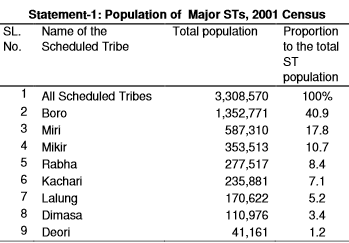
2.Among STs, Boro represents nearly half of the total ST population of the state (40.9 per cent). Miri (17.8 per cent), Mikir (10.7 per cent), Rabha (8.4 per cent), Kachari (i.e. Sonowal Kachari) (7.1 per cent), and Lalung (5. 2 per cent) are the other major STs each having 5 per cent or above of total STs. Along with Boro they constitute 90 per cent ST population of the state. Besides them, Dimasa consti tutes 3.4 per cent and Deori 1.2 per cent of the total ST population of the state. The rest of the Scheduled Tribes are very small in their population size (Statement-1).
3.The ST population in Assam is predominantly rural wi th 95.3 per cent rural and only 4.7 per cent urban population. Of the eight maj or STs, Dimasa have recorded the highest 10.4 per cent urban population, followed by M ikir (8.3 per cent). On the other hand Miri have recorded the lowest 1.8 per cent urban population.
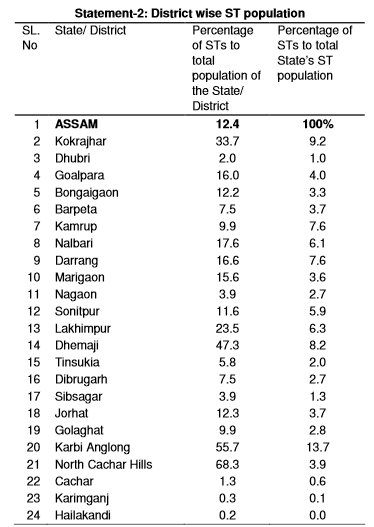
4.North Cachar Hills and Karbi Anglong the two autono mous hill districts of Assam are predominantly tribal housing two important S Ts of Assam – the Dimasa and Mikir (now recognized as Karbi). As per 2001 Census, the North Cachar Hills has got the highest 68.3 per cent ST population, followed by Karbi Anglong (55.7 per cent). In absolute number Karbi Anglong is on top sharing 13.7 per cent of the total ST population of the state. Hailakandi, Karimganj, and Cachar distri cts have a negligible presence of ST population (Statement-2).
Sex Ratio
5.The overall sex ratio of ST population is 972, which is below the national average for STs (978). Of the eight major STs, Lalun g have recorded the highest sex ratio of 985, while it is the lowest among Dimasa (951). The state has recorded child sex ratio (0-6 age group) of 962, which is again lower th an the national average (973) for STs. The child sex ratio among Kachari (Sonowal) of 94 5 is the lowest, followed by Lalung (949).
Literacy & Educational Level
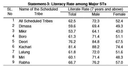
6.The ST population of Assam has recorded 62.5 per cent literacy rate, which is well above the national average for STs (47.1 per ce nt). The male and female literacy rate of 72.3 per cent and 52.4 per cent respectively show that women are lagging behind by 19.9 percentage points.
7.Kachari (Sonowal) with 81.4 per cent literacy rate a re well ahead of others. On the other hand it is low among Mikir (53.7 per cent). Among Kachari (Sonowal), the female literacy rate of 74.4 per cent is quite close to male (88.2 per cent). Gender gap in literacy among Miri, however, has been recorded to be the highest. With 71.4 per cent male and 48.3 per cent female literacy, the Miri wome n are lagging way behind by as much as 23.1 per cent points (Statement-3).
8.A two third (65.4 per cent) of the ST population in the age group 5-14 years has been attending schools or any other educational institutions. Of the eight major STs, it is the highest among Kachari (Sonowal) with 80.2 per cent of their population of this age group attending educational institutions. In addition Deori (79.8 per cent), Rabha (70.2 per cent), and Boro (68.2 per cent) have also register ed this proportion above state average for STs, while Mikir have registered below th e state average (54.9 per cent). Almost half of the Mikir population in the age group of 5-14 years – the category of potential students – has not been attending schools. 9.Literates among STs who are having educational level graduation and above are 2.3 per cent only. Deori is well ahead, among the eight major STs in Assam, with 4.9 per cent graduate and above. Mikir, Rabha, and Lalun g are at the bottom, each having less than two per cent of their literate population wi th educational level graduation and above.
Work Participation Rate (WPR)
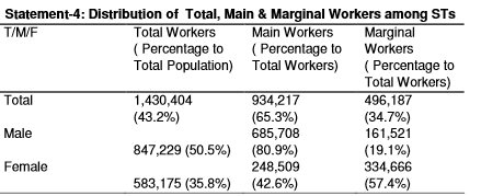
10.According to 2001 Census, 43.2 per cent of the STs have been registered as workers, which is below the aggregated national figure for STs (49.1 per cent). Of the total workers 65.3 per cent are main workers and 34.7 per cent marginal workers. The WPR of 35.8 per cent among females is high though lower than males (50.5 per cent). Gender wise disparity is, however, distinct in case of m ain workers; 80.9 per cent among males and only 42.6 per cent among females are main workers (Statement-4).
11.Among the major STs in the state, Deori have record ed the highest WPR of 55.5 per cent. It is lowest among Dimasa (38.9 per cent) Deori have recorded almost equal participation of male and female in the workfor ce with 58 per cent male and 52.9 per cent female WPR. On the contrary the gender gap i n WPR is quite significant among Rabha (male 51.2 per cent, female 30.7 per cent), La lung (male 51.8 per cent, female 33.1 per cent), and Dimasa (male 47 per cent, female 3 0.4 per cent).
Category of Workers
12.The Scheduled Tribes of Assam are predominantly culti vators as 70.6 per cent of the total ST main workers have been recorded as culti vators, while merely 6.1 per cent as agricultural labourer.
13.At the individual ST level, Miri have recorded a high of 85.6 per cent of their total main workers as cultivators, closely followed by Mi kir (79.3 per cent) and Deori (78.2 per cent). Rabha have recorded the highest percentage o f agricultural laborers, which is only 9 per cent of total main workers thereby indicati ng that majority of the STs in Assam are not landless.
Marital Status
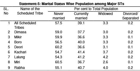
14.The distribution of ST population by marital statu s shows that 57.5 per cent is never married, 39.1 per cent currently married, 3.3 p er cent widowed, and merely 0.2 per cent divorced /separated. There is no conspicuous variatio n among the different individual STs (Statement-5).
15.As regards child marriage, 1.6 per cent of the ST fe male population below 18 years – the minimum legal age for marriage – has been recorded as ever married. Among the twelve major STs, Lalung have registered t he highest at 2 per cent of their female population of this age category as ever marri ed, while it is the lowest at 1.3 per cent among Miri.
16.The ever married males below 21 years – the minimu m legal age for marriage – constitute only 1.4 per cent of the total ST populat ion of this age category. Of the eight major STs, Lalung have registered the highest at 1.6 per cent of their male population below the stipulated age as ever married, closely follo wed by Deori and Miri, each with 1.5 per cent. Dimasa have registered the lowest at 1.2 per cent.
Religion
17.Of the total ST population of Assam, 90.7 per cent are Hindus and 8.8 per cent Christians. Besides these two main religions, 6,267 per sons are Muslims, 5,153 Budhists, and another 3,574 persons have returned pursuing var ious other faiths and have been categorized under “Other Religions and Persuasions”.
History
[ From the archives of The Times of India]
Dhananjay Mahapatra
How illegal immigrants morphed into an invaluable vote-bank
It can happen only in India, where vote-bank politics scores decisively over national interest and issues relating to India’s sovereignty. How else can one explain the cunningness shown by the Centre and the Assam government to disregard the remedial measures suggested by two screaming Supreme Court judgments, which highlighted the demographic aggression faced by Assam from incessant influx of illegal migrants?
In 1971, India was complaining in the UN about the aggression it faced from the huge population shift that was taking place from East Pakistan to its northeastern part. Strangely, 40 years later, the illegal migrants have become an invaluable vote-bank for certain political parties, which hedge the question of their identification and deportation, despite clear directions from the apex court in two rulings in 2005 and 2006.
In 1971, the Sixth Committee of General Assembly was debating to define “aggression”. India’s representative Dr Nagendra Singh voiced serious concern about the incessant flow of migrants from East Pakistan into India and termed it as an aggression to unnaturally change the demographic pattern. Surely, India was preparing a ground for lending active military support to Mukti Bahini in the creation of Bangladesh. Dr Singh supported Burma (now Myanmar), UK and others and said a definition of aggression excluding indirect methods would be incomplete and therefore, dangerous. “For example, there could be a unique type of bloodless aggression from a vast and incessant flow of millions of human beings forced to flee into another state. If this invasion of unarmed men in totally unmanageable proportion were to not only impair the economic and political well-being of the receiving victim state but to threaten its very existence, I am afraid, Mr Chairman, it would have to be categorized as aggression,” he said.
“In such a case, there may not be use of armed force across the frontier since the use of force may be totally confined within one’s territorial boundary, but if this results in inundating the neighbouring state by millions of fleeing citizens of the offending state, there could be an aggression of a worst order,” he had said while arguing for a broader meaning of aggression to include unmanageable influx of migrants. The illegal migration did not subside even after Bangladesh came into being. A sixyear violent agitation against illegal migrants led to signing of the Assam Accord in 1985 between Assam student leaders and then PM Rajiv Gandhi. It promised a comprehensive solution to the festering problem. In 1998, the then Assam governor sent a secret report to the President informing that influx of illegal migrants from Bangladesh continued unabated into the state, perceptibly changing its demographic pattern and reducing the Assamese people to a minority in their own state. It had become a contributory factor for outbreak of insurgency in the state, he said.
The SC in the Sarbananda Sonowal [2005 (5) SCC 665] case quoted from the governor’s report to say, “Illegal migration not only affects the people of Assam but has more dangerous dimensions of greatly undermining our national security. ISI is very active in Bangladesh supporting militants in Assam. Muslim militant groups have mushroomed in Assam. The report also says that this can lead to the severing of the entire land mass of the northeast with all its resources from the rest of the country which will have disastrous strategic and economic consequences.”
The political game over illegal migrants came to the fore in 2000. The AGP government in August 2000 presented disturbing statistics to the SC — Muslim population of Assam went up by 77.42% between 1971 and 1991 while Hindu population increased only by 41.89%. In September 2000, this affidavit was quickly withdrawn by the Tarun Gogoi government immediately after coming to power. The Gogoi government also defended continuance of Illegal Migrants Determination through Tribunal (IMDT) Act, repeal of which was sought by the AGP government on the ground that it was totally ineffective in identifying illegal migrants.
The SC termed incessant flow of illegal migrants into Assam as “aggression” and castigated the Centre for failing in its duty under Article 355 to protect the state. It said, “There can be no manner of doubt that Assam is facing ‘external aggression and internal disturbance’ on account of largescale illegal migration of Bangladeshis. It, therefore, becomes the duty of Union of India to take all measures for protection of Assam from such external aggression and internal disturbance as enjoined in Article 355.”
It quashed the ill-suited IMDT Act and directed effective identification of illegal migrants through tribunals under the Foreigners Act. Instead of implementing the directive, the Union and Assam governments attempted to obfuscate the issue by passing a new notification giving relief to illegal migrants from imminent identification. SC saw through the game and in December 5, 2006, pulled up both the governments [Sonowal-II, 2007 (1) SCC 174]. The problem of illegal migrants raised its ugly face yet again in Assam through recent riots. Other northeastern states have also been nervously watching similar demographic situations building up. It is time for the Centre and Assam, who are morally in contempt of the two SC rulings, to take concrete and decisive measures to solve the problem. Else, we will witness Assam-like flare-ups in more northeastern states.
The religious demographics of Assam: 2011
The Times of India, Aug 26, 2015
Bharti Jain
Muslim majority districts in Assam up
Assam, where illegal immigration from Bangladesh has been a concern, continues to show demographic changes with the 2011 Census finding nine of its 27 districts to be Muslim-majority . Adding to six such districts listed in 2001 Census, the 2011 Census has shown Bongaigaon, Morigaon and Darrang to be Muslim-majority. In 2001 Census, the districts in Assam with a larger Muslim population as compared to Hindus, were Barpeta, Dhubri, Karimganj, Goalpara, Hailakandi and Nagaon. Bongaigaon then had 38.5% Muslim population, Morigaon 47.6% and Darrang 35.5%.
As per 2011 Census, Dhubri has 15.5 lakh Muslims compared to 3.88 lakh Hindus, Goalpara has 5.8 lakh Muslims and 3.48 lakh Hindus, Nagaon 15.6 lakh Muslims and 12.2 lakh Hindus, Barpeta 11.98 lakh Muslims and 4.92 lakh Hindus, Morigaon 5.03 lakh Muslims and 4.51 lakh Hindus, Karimganj 6.9 lakh Muslims and 5.3 lakh Hindus, Hailakandi 3.97 lakh Muslims and 2.5 lakh Hindus, Bongaigaon 3.71 lakh Muslims and 3.59 lakh Hindus and Darrang 5.97 lakh Muslims and 3.27 lakh Hindus. Other districts with a significant share of Muslims are Cachar (6.5 lakh against 10.3 lakh Hindus), Kamrup (6.01 lakh Muslims against 8.77 Hindus) and Nalbari (2.77 lakh Muslims against 4.91 lakh Hindus).
In 1998, then governor of Assam S K Sinha had, in a report on illegal influx of Bangladeshi immigrants into Assam, warned that the “silent demographic invasion of Assam may result in the loss of the geostrategically vital districts of Lower Assam“.
Assamese language, promotion of
Hoardings in Assamese must in Guwahati: 2016
The Times of India, January 21, 2016
Pranjal Baruah
Hoardings in Assamese must in Guwahati
The Kamrup (Metro) district administration ordered all business and commercial establish ments to use Assamese as the primary language in their ho ardings and signage. It set Ja nuary 31 as the deadline for the establishments to implement the order or face action. “It's about the use of Assa mese, the official language,“ Kamrup (Metro) district com missioner M Angamuthu said “The district administration will make it functionally com pulsory in all business and com mercial establishments, especi ally for signage and hoardings.“
Angamuthu said necessary action would be taken against the violators. These establish ments can also use English as the secondary language, besi des Assamese, he said.
