Climate: India (the seasons)
This is a collection of articles archived for the excellence of their content. Readers will be able to edit existing articles and post new articles directly |
Contents |
Climate: India (the seasons)
January fog
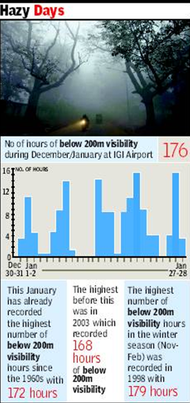
Foggiest Jan since ’60s, low visibility for 172 hrs
TIMES NEWS NETWORK
2010
New Delhi: With the last spell of fog on January 27 and 28, this month is now officially the foggiest since the 1960s, having clocked a total of 172 hours of below 200 m visibility. The good news is that the Met department does not foresee too many dense fog spells in the remaining days of the month.
This winter season has been unique in the sense that December recorded only 4 hours of below 200 m visibility against record-breaking January, and those also on the last day of the month.
Met officials say that the current month has been plagued by persistent calm systems with no strong winds, a substantial moisture supply and middle latitude systems that regularly brought in cold air — the combination of which proved ideal for dense fog formation.
‘‘This month has seen only five days which had no dense fog. Between January 9 and 13, visibility did not fall so much while the worst phase has been from the 19th to the 22nd which saw 33 hours of below 200 m visibility,’’ said R K Jenamani, director in-charge, IGI Met.
The city finally got a respite from fog on Thursday though part of the new runway experienced low visibility during the early morning hours. That did not have any impact on flight movement as the runway was not in use during that period.
The maximum temperature went up to 26.6 degrees Celsius, five degrees above normal, while the minimum recorded was 10.1 degrees Celsius, two degrees Celsius above the normal temperature.
After a long foggy winter, Delhiites on Thursday, enjoyed a warm sunny afternoon though the early part of the day remained cloudy under the impact of a western disturbance that is currently over northern Pakistan and Jammu and Kashmir.
‘‘While there are chances of rain over the plains of northwest India, Delhi might only experience a cloudy sky. Another western disturbance is approaching and only after it arrives can a trend be analysed for the weather,” said a Met official.
He added: “There might be another spell of fog around January 30, but as of now the fog conditions will not be as dense as it was witnessed recently and it might not last for such sustained periods.’’
Amritsar — which has so far been the coldest city in the north-west plains recording sub-zero temperatures on several days — recorded a minimum of 4.8 degrees Celsius on Thursday though it still retained its title of the coldest city.
The minimum temperatures over western Himalayas, Punjab and Haryana remained 2-4 degrees Celsius above normal and no significant change in temperature is likely for another day or so.
toireporter@timesgroup.com
March 2010
This March was the 2nd warmest ever recorded
TIMES NEWS NETWORK
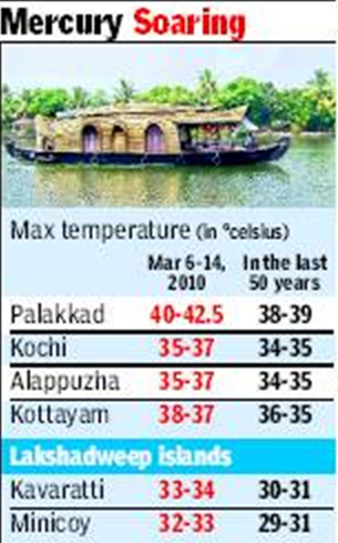
New Delhi: During the course of last month, many Delhiites swore they had never experienced such high temperatures in the capital this time of the year. They were absolutely right. March this year was the second warmest in Delhi since systematic records began in 1901, the Met department said on Friday. The only time Delhi had a warmer month of March was way back in 1953.
In what perhaps signals a long and hot summer ahead, the mean maximum and minimum temperatures for March 2010 were 33.8 degrees Celsius and 18.6 degrees Celsius — significantly higher than the normal values of 30 degrees Celsius and 15.4 degrees Celsius, respectively. Only in 1953 was the mean maximum temperature in March higher, at 34.3 degrees Celsius.
The month’s mean temperature (average of mean maximum and mean minimum temperatures) was 26.2 degrees Celsius, again the second highest behind 26.4 degrees Celsius for March 1953.
Ajit Tyagi, DG, Indian Meteorological Department said April too is expected to be warmer than usual, as is the rest of the summer. Winds from south & west made March hot
New Delhi: March this year was the second warmest in Delhi since systematic records began in 1901, the Met department said on Friday. ‘‘The high temperatures weren’t restricted to the region. Almost all of the Asian continent, including south China, has been exceptionally warm in the past month or so,’’ said Ajit Tyagi, DG, Indian Meteorological Department.
The Met department attributed the warm spell to winds coming from the west and south instead of the normally prevalent northwesterly to northerly winds. This was due to an absence of a western disturbance (WD), which made a brief appearance towards the end of the first week, leading to a cooling trend in the second week of March.
‘‘Also, there was no rain over the northern plains this month,’’ Tyagi said. ‘‘Another factor is regional variation. Europe and America are having colder weather and some disturbances. That could be a reason why Asia is witnessing a warm phase. This summer could follow a similar pattern.’’
The month began on a warm note with both maximum and minimum temperatures 5-6 degrees C above their normal values. It was only during the second week when they were near normal, under the influence of a WD. By the end of the third week, temperatures were again 5-6 degrees C above normal and remained so till end of the month.
The highest maximum temperature during the month was 39.2 degrees C recorded on 22 March, whereas the all time record for the city is 40.6:C recorded on March 11, 1915. Since 1901, there have been only 5 years when maximum temperatures in excess of 39.2 degrees C have been recorded in March.
Nights getting warmer in India
Yields Of Rice, Other Cereals Could Be Hit
Amit Bhattacharya | TNN 2010
New Delhi: In an ominous sign of climate change hitting home, India has seen accelerated warming in the past few decades and the temperature-rise pattern is now increasingly in line with global warming trends. The most up-to-date study of temperatures in India, from 1901 to 2007, has found that while it’s getting warmer across regions and seasons, night temperatures have been rising significantly in almost all parts of the country.
The rise in night temperatures — 0.2 degrees Celsius per decade since 1970, according to the study — could have potentially adverse impact on yields of cereal crops like rice. The paper also finds that warming has been highest in post-monsoon and winter months (October to February).
‘‘Until the late 1980s, minimum (or night) temperatures were trendless in India. India was an odd dot in the global map as most regions worldwide were seeing a rise in night temperatures in sync with growing levels of greenhouse gases. Our analysis shows the global trend has caught up with India,’’ said K Krishna Kumar, senior scientist and programme manager at Indian Institute of Tropical Meteorology, Pune, and one of the authors.
Regional factors seem to be getting over-ridden by warming caused by greenhouse gases. For instance, the cooling trend in much of north India seen in the 1950s and 60s has been reversed, possibly because the effect of aerosols in the air can no longer compensate for greenhouse gas warming.
Heat Is On
In last 100 yrs, mean temp has risen .82°C worldwide, and .51°C in India
However, India has seen sharp temp rise in recent decades. Since 1970, minimum temp up by .20°C/decade, faster than max temp (.17°C)
Western Himalayas warming up alarmingly at .46°C per decade
Across India, warming is sharpest during winter (.30°C per decade) and post-monsoon (.20°C) months Himalayan regions bear warming brunt
New Delhi: A study on temperatures has found evidence of accelerated warming in India. The study — Surface air temperature variability over India during 1901-2007 and its association with ENSO — by IITM scientists D R Kothawale and A A Munot besides Kumar, is a comprehensive analysis of temperature data gathered from 388 weather stations in the country and has been accepted for publication in the international Climate Research journal.
The rising night temperatures are a major cause of worry. Said Jagdish K Ladha, principal scientist in the India chapter of International Rice Research Institute, ‘‘Minimum temperatures have a link with rice fertility. At higher than normal night temperatures, rice grains aren’t properly filled up, leading to a drop in yield.’’
During 1901 to 2007, the all-India mean, maximum and minimum annual temperatures rose at the rate of 0.51, 0.71 and 0.27 degrees Celsius per 100 years, respectively.
However, post 1970, the rise has been sharper with mean and minimum temperatures both increasing at the rate of 0.2 degrees per decade, faster than the maximum temperature which rose by 0.17 degrees.
Among regions, the hardest hit seems to be the western Himalayas encompassing portions of Jammu & Kashmir, Himachal Pradesh and Uttarakhand. Here the mean temperature rise in the last century was 0.86 degrees while, more recently, temperatures have been going up by as much as 0.46 degrees per decade. The rapid warming of the region would have obvious fallouts on glacier melts.
On a seasonal scale, winter and post-monsoon temperatures show significant warming trends in recent decades though temperatures in other months have also been going up more modestly.
Delhi April
Minimum temp 10°C above normal
But Met Dept Says This Week Could Be Better, Rain Expected By Tuesday
TIMES NEWS NETWORK
New Delhi: Going by the temperature trends so far, 2010 could turn out to be even warmer than the previous year that currently holds the record for the warmest year since 1900. After recording the highest maximum temperature in April since the past 52 years on Saturday, Sunday recorded the highest minimum in April since 1970 with 30.6 degrees celsius, which is 10 degrees above normal.
The coming week might be slightly better with Delhi expected to see some thundershowers around Tuesday and a slight fall in temperature.
The maximum temperature on Sunday was 43 degrees celsius, seven degrees above normal, not much lower that what was recorded on Saturday. However, the small difference between the maximum and minimum ensured that the city had no respite from the heat the entire day. Officials said that records for April were available since 1970 and since then, this had been the highest minimum. The record before this was set in 1988 with a minimum of 30.1 degrees celsius.
According to Met officials, the western disturbance that might bring rain to the city a little later in the week is what led to such high temperatures initially. ‘‘The WD is affecting the hilly states right now because of which there was a change in the wind direction. The southern winds that are blowing over the northwest region at present are bringing in moisture because of which there was cloud cover over Delhi on Sunday morning. This is what caused the minimum temperature to rise,’’ said B P Yadav, director, IMD.
The WD is going to bring relief for entire northwest India that is presently reeling under a severe heat wave. ‘‘There is a possibility of isolated rain and thundershowers over all of northwest India and there will be a gradual decrease of temperature over the next week,’’ added Yadav.
The weekend turned out to be a proverbial damp squib for Delhiites considering the fact that the city felt more like a toaster. People chose to remain indoors. ‘‘Spending even five minutes out in the open was enough to make me feel ill. I had plans to go to the movie but my parents put their foot down and asked me to go out only at night if it was so urgent,’’ said Sudhi Mehrotra, a student.
Delhi April II
Delhi’s hottest April in 52 years
TIMES NEWS NETWORK
New Delhi: Planning to watch today’s IPL match at Firozshah Kotla? Make sure you cover up well and remain hydrated. The Met has warned that Delhi will be like a furnace till Monday. Saturday recorded the highest temperature in April since 1958 with the maximum touching 43.7 degrees Celsius, eight degrees above normal. There was thought to be a chances that Sunday would be worse.
Saturday’s dry, scorching sun underlined repeated warnings that summer would be particularly unpleasant this year. From Friday, even the minimum temperature rose to 26.5 degrees Celsius, six degrees above normal. Last April, temperatures touched 43.5 degrees Celsius but the month was recorded the hottest on April 29, 1941 when temperatures touched 45.6 degrees Celsius. Saturday’s maximum was the highest in 52 years, reaching the same level as — 43.5 degrees — as on April 27, 1958. The Met department predicts that the heat wave will continue over northwest India till Sunday after which a western disturbance would bring some relief. Accordingly, it’s thought Delhi will remain stiflingly hot till Sunday, after which temperatures will fall marginally to about 40 degrees Celsius. A western disturbance, approaching the western Himalayan region, will bring rain to Himachal Pradesh and maybe even Punjab.
MERCURY RISING
43.7
temperature recorded on Saturday
45.6
the highest temperature for April in 1941 It’s April’s
highest temperature
since 1958
8°C above normal
Minimum temperature rises to 26.5°C,
6°C above normal Power demand goes up and up on sizzling Saturday
Met expects some relief from Monday
New Delhi: The Met department says the heat wave will continue till Sunday after which a western disturbance might bring some relief. Once the wind direction changes, Delhi’s temperature will start coming down and remain like that for about four days or so. “However, we are not expecting any rain over Delhi though it may a little cloudy,” said B P Yadav, director, IMD.
Since last year, most months have seen higher mean temperatures as compared to the normal mean temperatures. Last March also happened to be the second hottest March since 1900.
Met DG Ajit Tyagi had said earlier in the year that temperature trends were pointing towards a warmer than usual summer. Recently, the Centre for Science and Environment claimed that the steady rising trend in temperatures could well be an indicator of global warming though several weather experts are looking at this as a decadal variation. “It is still too soon to say that this is an impact of global warming though it is but evident that temperatures are higher than they have been in several years,” said sources.
Aditi Khosla, a resident of Panchshila Park, was on her way to east Delhi on Saturday when she got caught in a traffic jam near Chirag Dilli. “I was taking my 4-year-old daughter to my parents house and it was torture for both of us. The airconditioning in the car was least effective and both of us came down with severe headaches by the time we reached Mayur Vihar,” she said.
June
Coolest day in June since 2000
TIMES NEWS NETWORK
New Delhi: It was perhaps one of the most pleasant days in June, one that Delhiites would remember for a while. Thanks to an overcast sky and a light breeze, the maximum temperature on Tuesday came down to 26.9 degrees Celsius — a massive 14 degrees below normal. No wonder the day was the coolest in June since 2000 and the second coolest in the past 40 years.
Met officials said the temperature dropped as the sky remained overcast on two consecutive days. ‘‘Delhi did not receive any sunlight for over two days and there was a lot of moisture in the air. Because of this, the maximum temperature remained extremely low. The winds coming in from the northwest are also quite cool. Nearby areas, specially Rajasthan and parts of Haryana, have also been receiving a lot of rain both because of the now dying out cyclone and a western disturbance over the western Himalayas. Temperatures in these areas are also quite low and have affected the weather in Delhi,’’ said a Met official.
Tuesday’s minimum temperature was 22.1 degrees Celsius — six degrees below normal. Humidity ranged from 93% to 60% and 0.8mm rain was recorded at the Safdarjung observatory since 8.30am. ‘‘The last time the maximum temperature in the month went so low was in 2000 when 25.7 degrees Celsius was recorded on June 8. Before that, it was in 1970 when the temperature was even lower than that,’’ said an official.
According to sources, the WD — which is still persisting over the Himalayan region — is likely to impact the region for another two days. A low pressure area also persists just northwest of Uttar Pradesh and Uttarakhand. Due to this, areas like western UP, Punjab, Haryana and Delhi are expected to get scattered rain and thundershowers till Wednesday after which the sky is likely to clear up. The maximum temperature is also expected to start rising and should go up by 2-4 degrees before the weekend over northwest India. Aditi Tripathi, a DU student, said she was out with her friends all day only to be able to make the most of such weather before it became hot again. ‘‘I did not want to waste even a second of such a lovely day indoors. My friends and I went shopping, we ate out and also took a walk in Lodhi Gardens in the evening before returning home,’’ she said.
June: driest Junes 1923-2014
Third driest June, but relief in sight
Amit Bhattacharya New Delhi
TNN
The Times of India Jul 01 2014
With the monsoon arriving late and then stalling for long periods, this year’s June has ended up being the third driest on record, according to IMD data.
The monsoon deficit for the month was 43%.
The average countrywide rainfall in June was pegged at 92.4mm, the third lowest for the month in records dating back to 1901.
TOI had reported on Saturday that this June was in line to be among the driest. The scantiest rainfall in June took place in 2009, when rains failed under the shadow of an El Nino occurrence.
However, relief could be just days away. IMD said rains are set for a revival this week.
The delayed monsoon could be in for a revival this week. “Conditions are becoming favourable for monsoon's further advance into more parts of Uttar Pradesh and some parts of Uttarakhand, Himachal Pradesh, Jammu & Kashmir, Punjab and Haryana during the next three-four days,“ said B P Yadav, head of IMD's National Weather Forecasting Centre in New Delhi.
P Sivananda Pai, the lead monsoon forcaster at Pune's India Meteorological Department, said this year's monsoon has been weak for several reasons. “First, heating of the northern plains, an important factor that draws monsoon winds inland, began only in the first week of June. Then, there have hardly been any low pressure systems forming in the Bay of Bengal,“ he said. Yadav said signs were visible of a low pressure system developing over the Bay of Bengal in the next 24 hours, which would push rain-laden winds to the northern plains.
Since June constitutes just 17% of monsoon's rainfall, near-normal rains in the crucial months of July and August would go a long way in wiping much of the deficit. In 1926, for instance, the monsoon recorded a shortfall of 48% in June but the season ended with almost 7% above average rainfall due to a late surge in August and September.
Monsoon has been delayed in the grain bowl of Punjab, Haryana and west Uttar Pradesh by up to 10 days. Rains are expected to be deficient in the region, with IMD predicted 85% rainfall for the season in northwest India.
Delhi rainfall
Jun-Jul 2013: With 460mm rain, city’s wettest in 10 years
Amit Bhattacharya TNN
The Times of India 2013/08/04
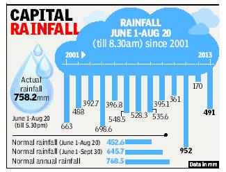
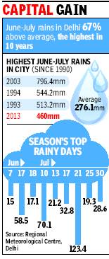
New Delhi: The first two months of the monsoon season have been wettest in the capital in the past 10 years. Delhi’s June-July rain tally stood at 460mm, 67% above normal, which is the second highest of this century after 2003.
The city’s rain aggregate got a huge boost in the second half of July. According to figures provided by the Regional Meteorological Centre, the capital got 238.9mm of rain during July 16-31, which is more than the average for the entire month.
There were 10 rainy days during this period, including the season’s wettest day (July 21), when 123.4mm came down on the city. This late surge lifted July’s rain tally to 340.5mm, 62% higher than the month’s average rainfall of 210.6mm. Since 1990, there have been only three years when the city has got more rain in June-July than this year. Apart from 2003, the other bountiful years were 1994 and 1993.
While the rain gods have been kind to Delhi, in neighbouring Haryana it’s been a different story. The meteorological district comprising Haryana, Delhi and Chandigarh is the only one in north India where rains have been deficient so far. That’s mainly because of poor rainfall in Haryana.


