Mapping: India
This is a collection of articles archived for the excellence of their content. |


The Times of India, Aug 30 2015
Manimugdha Sharma
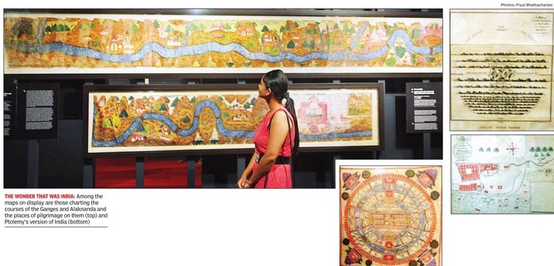
An exhibition at the National Museum showcases rare maps that capture India's evolution from painting mythical visions of the cosmos to fully imbibing the more modern concepts of cartography In the morning of September 7, 1746, French troops laid siege to the English-held town of Ma dras. The Fort St George in the centre of the town was defended by 200 guns, but had only 100 men to service them. Worse: the chief English gunner and bombardier, Smith, died of a heart attack on seeing the French come. Outgunned and outwitted, Madras fell in what was one of those rare occasions when the thin red line failed to hold the line. The French mapped their victory for posterity, which you can now see at the National Museum. The map is among 72 rare and unseen works of cartography from different periods in history that are part of an exhibition titled `Cosmography to Cartography'. And as the name itself suggests, the exhibition traces the evolution of map-making in India: from paintings depicting mythological vi sions of the cosmos to those charting courses of holy rivers like the Ganges and Alaknanda and places of pilgrimage on them; from more realistic military maps to products of laborious topographical surveys conducted by the British Raj.
But why should anyone see these maps? For the answer, we shall have to turn back the pages of history and go to the fag end of the 15th century when the Portuguese discovered the sea route to India.
The 16th century began with the gradual consolidation of the Portuguese hold over India's western coast and a lucrative trade between the Orient and Occident. Soon, other European powers were vying for a piece of this delicious pie. But they couldn't do it unless the Portuguese monopoly was broken. And this was possible only if the Portuguese route and the Indian subcontinent were mapped. Enter the cartographers, the first international spies who in their bid to outwit rival European powers unwittingly changed the history and geography of the world as we understand it today.
But while the Europeans were du elling with one another in the high seas, there was another group that was eyeing the riches of India. They were hardy people from the Central Asian steppes who had a major advantage over their European rivals--they were right at India's doorstep. The Mughals, as they would be known later, would also map their way into the subcontinent.
India, though, was oblivious to these manoeuvres and was producing rich paintings and tapestries schematizing the universe centred on the mythical Mount Meru. These were great examples of Hindu, Jain and Buddhist cosmography that shaped the religious and spiritual outlook of Indians, but proved inadequate for their political and geographical understanding of the subcontinent. So when foreign powers established their hegemony over the land, it was also a victory of cartography over cosmography .
Why cartography didn't flourish in India before the coming of the for eigners is still, as historian Joseph E Schwartzberg put it, “a matter for wonder, given India's major contribu tions to astronomy, geometry, and other branches of mathematics and the re markably creative exuberance of its culture“. But the exhibition in its en tirety certainly captures well the evolu tion of this great art in India by giving the visitor the chance to compare and contrast the exhibits. More than that, it helps one understand the history of India that's not possible inside a classroom.
“Maps are a very, very important means to study and understand history . Sadly, we Indians have never really put much premium on it. Those old maps were reflections of the foreigners' views of India, and these views were not necessarily accurate.Who had what sort of relations with India and the local powers here influenced the maps. Studied sepa rately, these will make for fascinating reads, but taken together, these would help us understand the history of In dia,“ said Sunil Baboo, a Bangalore based collector of old Indian maps and colonial papers.