Pakistan History: The Land And Its Early History
This article is an extract from |
NOTE 1: Indpaedia is an archive. It neither agrees nor disagrees
with the contents of this article.
NOTE 2: The Pakistanis’ view of their history after 1947 and, more important, of the history of undivided India before that is quite different from how Indian scholars view the histories of these two periods. The readers who uploaded this page did so in order to give others Mr. Wynbrandt’s neutral insight into Pakistan’s history. Indpaedia’s own volunteers have not read the contents of this series of articles (just as it was not possible to read any of the countless other public domain books extracted on Indpaedia).
If you are aware of any facts contrary to what has been uploaded on Indpaedia could you please send them as messages to the Facebook community, Indpaedia.com. All information used will be gratefully acknowledged in your name (unless you prefer anonymity).
See also
Indpaedia has uploaded an extensive series of articles about the Pakistan Movement, published in Dawn over the years, and about the various Pakistani wars with India published in the popular media. By clicking the link Pakistan you will be able to see a list of these articles. The Pakistan Movement articles are presently under 'F' (for freedom movement).
The Land And Its Early History
Few nations have as rich or complex a history as the Islamic Republic of Pakistan. Its destiny has been shaped first by its geography The violent collision of continents that formed this land threw up great mountains that made this corner of the subcontinent a place apart. The sequestered, fertile environment of the Indus Valley nurtured one of the world's first great civilizations. Yet the passes that breached the guard- ing massifs served as funnels through which invaders both hostile and friendly have poured for millennia. These outsiders have been the sec- ond great ingredient in Pakistan's destiny. They brought their traditions, ideas, and ways of life, all of which have become part of the nation's identity. This chapter surveys the nation's physical landscape, its first civilizations, and the provinces that today reflect the historical divisions that have made Pakistan's past and present so vibrant, dynamic, and tumultuous. The chapter also introduces the Aryans, the first of the interloping groups that would shape the history and heritage of what is today Pakistan. The Aryans' experiences here would give rise to the Hindu religion, which continues to be a force with a powerful effect on the region today.
Geology and Geography
Before the continents as we know them came to be, the land that is now Pakistan and India were part of Gondwanaland, an ancient super- continent. Some 200 million years ago Gondwanaland began to break apart, torn by tectonic forces. Over time the supercontinent's rem- nants formed landmasses including Africa, South America, Antarctica, Australia, the Arabian Peninsula, and the Deccan Plateau, or the Indian subcontinent. At the time the Eurasian landmass was separated from the disintegrating supercontinent by a long, shallow sea. The streams and rivers that drained what we know now as Asia deposited sandy runoff into this basin while the calcified remains of sea creatures likewise accreted. Over time these deposits became sandstone and limestone. After Gondwanaland splintered, the future Deccan Plateau moved north, toward Eurasia. As the two landmasses drove toward each other, the sandstone and limestone that had carpeted the sea floor between them was thrust upward. At least 45 million years ago the landmasses met.
The submarine deposits ultimately became the fold mountains that now form a ridge across southern Asia from the Mediterranean to the Pacific. The contorted, visible bowing of the sedimentary rocks from which the mountains formed bears evidence of the compression caused by the slow tectonic collision. The peaks reach their highest point at the north end of the subcontinent. These are the Himalayan Mountains. Marine fossils found on Mount Everest, the world's highest peak, attest to its undersea ancestry. The Himalayas and its offshoots, which flank southward on the east and west sides of the subcontinent, have served as a natural barrier to both the elements and humanity, separating the lands that became Pakistan and India from the rest of Asia. By 11 million B.C.E. migration of animals from and to the subcontinent had ended.
Topography
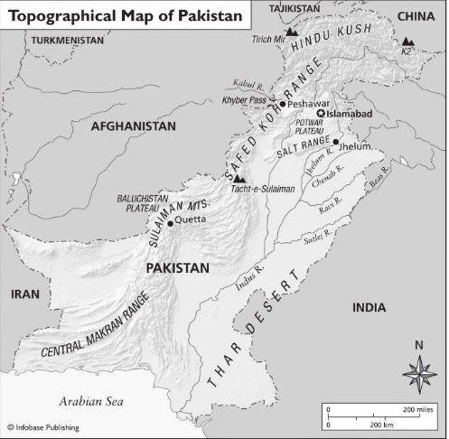
To its south, west, north, and northeast, natural barriers of mountain and sea have sheltered Pakistan. But to the southeast, the land spills out into the Deccan, the vast peninsular homeland of India. The Indus River, historically the lifeblood of what would become Pakistan, and its tributaries drain the plateau. Though its terrain is varied throughout the country, Pakistan can be divided into three basic geographic areas: the northern highlands, the Baluchistan Plateau, and the Indus River plain. These areas can be further segmented into the Salt Mountains and the Potwar Plateau, north of the Indus Plain; the Western Mountain region (composed of the mountains in western Baluchistan); and the Upper and Lower Indus River Plain (roughly corresponding with the present- day provinces of Punjab and Sind, respectively).
The Arabian Sea forms Pakistan's southern border. Its western border is shared with Iran in the south and Afghanistan in the north. Along Pakistan's northern border the slim arm of Afghanistan's Wakhan region separates Pakistan from Tajikistan. China's territories of Xinjiang and Tibet lie on Kashmir's border to the north and east. To Pakistan's east
The Indus River
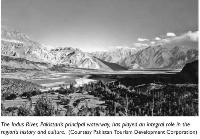
The Indus River is Pakistan's principal waterway. Known as the Sindhu in Sanskrit, the Sinthos in Greek, and the Sindus in Latin, it has been integral to Pakistan's culture and history, yet paradoxically gave its name to India, Pakistan's neighbor and rival. Its headwaters are in the Himalayas in Tibet. It flows northwest through Gilgit-Baltistan in Kashmir before turning south and traversing the length of Pakistan, its total length between 1,800 and 2,000 miles (2,900-3,200 km). The river gave birth to one of the world's first great civilizations, the Indus Valley Civilization. The course of the river has changed since ancient times as a result, it is believed, of earthquakes and other shifts of the land. Today it is damned at Tarbela, at the foothills of the Himalayas between Peshawar and Rawalpindi. Shortly after Pakistan became independent in 1947, India, which was given the region with the river's headwaters by the British, shut the flow of water to the Indus, creat- ing a grave crisis that took more than 15 years to resolve
are the Indian states of Punjab and Rajasthan. The Thar Desert serves as a barrier between these Indian lands and Pakistan. Despite the absence of any other barriers between these two states, historically they devel- oped independently.
The Himalayas
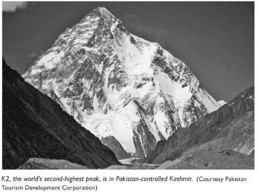
The Himalayas (meaning "the abode of snow" in Sanskrit) extend in a long bow some 1,500 miles (2,400 km) across the north end of the subcontinent, from the Indus River in the west to the Brahmaputra River (which originates in Tibet and ends in the Bay of Bengal) in the east. Four major ranges comprise the Himalayas: The Outermost, or Sub-Himalayas, are the farthest south. Its low hills, known as the Siwaliks, rise to about 3,000 feet (914 m). To the north lie the Outer, or Lesser Himalayas, whose peaks average 14,000-15,000 feet (4,267-4,572 m). Behind the Pir Panjal Range of the Outer Himalayas rise the Central, or Great Snowy Himalayas. In the Karakoram Range, permanently snow-covered peaks average 20,000 feet (6,096 m) in height and include Mount Everest, the world's loftiest peak (29,028 feet; 8,848 m), and in Pakistan-controlled Kashmir, K2, the world's second highest peak (28,251 feet; 8,611 m).
North of Pakistan's border is the Ladakh Range, or Inner Himalayas.
In Pakistan's northwest is the Hindu Kush (Hindu Killer) Range, extending from the high plateau of Pamir, sometimes called the Roof of the World, into Afghanistan. Tirich Mir is its highest peak (25,289 ft.; 7,708 m).
The Himalayas have had important historical and climatological effects on Pakistan and the entire subcontinent. They capture mois- ture-laden winds from the Arabian Sea (and to the east, the Bay of Bengal) and create rain that irrigates the region. In winter they block cold winds from North and Central Asia, keeping the subcontinent's climate mild. Spring melt-offs provide water. Historically the Himalayas and contiguous ranges have also formed a barrier protecting the region from the incursions of outsiders. Several passes along Pakistan's west- ern and northern borders provide routes in and out of the nation and have been key transit points throughout recorded history.
Western Mountains
In Baluchistan, west of the Indus Plain, three minor ranges run parallel south from the Hindu Kush to the Kabul River, their valleys draining the Swat, the Panjikora, and the Chitral-Kunar Rivers.
The Safed Koh Range, which runs east-west, has peaks averag- ing about 12,000 feet (3,657 m). The Khyber Pass, the most famous of the high-elevation gateways to the subcontinent, cuts through its mountains. About 33 miles (53 km) in length, the pass extends from Jamrud, some 10 miles (16 km) from Peshawar, Pakistan, to Dakka in Afghanistan. South of the range is the Kurram River. The Kurram Pass, which goes through Parachinar, Thai, and Kohat, has long been another favored route to Afghanistan. To the south, the Waziristan Hills lie between the Kurram and Gomal Rivers. The Gomal Pass, named for the Gomal River, which feeds into the Indus, has been an important trade route between Afghanistan and Pakistan for nomadic tribes known as the Powindahs. (Today their entry into Pakistan is restricted.)
South of the Gomal River the Sulaiman Mountains extend for 300 miles (483 km). The main peak, Takht-i-Sulaiman, is 11,100 feet (3,383 m). The Bolan Pass is the most noted transit point of these mountains and the Bolan their main river. The Pakistan city of Quetta guards the northern end of the pass. From here the land descends to the Kirthar Hills, low parallel ranges of some 7,000 feet (2,134 m) in elevation. They get little monsoon rainfall and are barren.
West of the Sulaiman and Kirthar Mountains the land descends to the dry hills of the Baluchistan Plateau, running northeast to southwest at an elevation of about 1,000 feet (305 m). The coastal Makran range borders the south end of Pakistan's western boundary.
The Salt Range and the Potwar Plateau
The Salt Range extends from near Jhelum, on the Jhelum River, north- west to the Indus River and then south into the districts of Bannu and Dera Ismail Khan in the North- West Frontier Province (NWFP). Its peaks average 2,200 feet (671 m) in height, though they reach about 5,000 feet (1,524 m) near Sakesar. In addition to extensive deposits of salt, its steep rock faces in the north contain gypsum, coal, and other minerals. The Salt Range has also attracted the attention of geologists, as it contains one of the world's most complete geological sequences, from the Cambrian to the Pleistocene eras.
The Potwar Plateau extends north of the Salt Range. The elevation ranges from 1,000 to 2,000 feet (305-610 m). The landscape is varied, shaped by glacial erosion. During the last ice ages glaciers that covered Kashmir and much of the northern subcontinent extended over this now semiarid region, creating the plateau's hills and hillocks.
The Indus Plain
South of the Salt Range the vast Indus Plain, drained by the Indus River and its tributaries, stretches to the Arabian Sea. The plain is composed of fertile alluvial deposits left by the overflow of the rivers. Several rivers in addition to the Indus traverse the Himalayan ranges. Their enormous flows in the rainy season often flood the surrounding plains. The northern part is called the Punjab and gives its name to the province that occupies the land. Most of this area is in Pakistan. The elevation here ranges from 600 to 1,000 feet (183-305 m).
The land between two rivers is referred to as a doab. The Indus has five major tributaries, and thus Punjab has four doabs. The combined waters of these tributaries, before joining the Indus near Mithankot, is called the Panjad (five rivers), thus the name of the province. The Indus and its five major tributaries join in Sind south of Mithankot. Here the land is flat, the river slow and wide, several miles across in the wet season. Silt on its banks forms a natural barrier, but at times the river has broken through and caused vast flooding, and has changed course. Near the coast a delta and flood plain form the mouth of the Indus. A coastal strip five to 25 miles (8-40 km) wide contains scattered mangrove swamps. Canals have been cut through the area, providing access for water traffic and trade. The Thar Desert occupies the southeast portion of the Indus Plain, spanning both Pakistan and India.
Climate
Generally arid, Pakistan lies in a warm temperate zone. The year is popularly regarded as having three seasons: summer, rainy season, and winter. Hot, summery weather lasts from April to September, and cold winters stretch from October to March. Monsoon rains drench the region from July to September. Within its borders the country has four primary climactic regions. The northern and north- western mountains have very cold winters with frequent frosts and heavy snowfalls. Summers are mild. On the plains to the south, the low elevation and absence of sea breezes cause very hot summers. During summer days, dry winds called loo blow. In the coastal areas to the south the Arabian Sea provides a moderating influence, and temperature variations are less extreme. The Baluchistan Plateau has a climate similar to that of the northern regions, though warmer in both summer and winter.
The Provinces
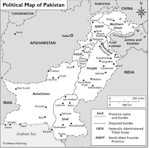
Today Pakistan is composed of four provinces, Punjab, Sind, the North- west Frontier Province (NWFP), and Baluchistan, and the Federally Administered Tribal Areas (FATA), a region between southwest NWFP and Afghanistan largely outside of government control. The state of Jammu and Kashmir is claimed by both Pakistan and India, and the dispute over the territory has been the defining issue dividing the two nations and inflaming passions on both sides of the border. The portion of Jammu and Kashmir that is administered by the federal government of Pakistan is divided into the Federally Administered Northern Areas, commonly known as the Northern Areas, and Azad Kashmir.
Punjab
Punjab is the most populous and developed of the four provinces. Noted for its arts and crafts, it is considered the cultural capital of Pakistan. Covering an area of 97,192 square miles (205,346 sq. km), Punjab is primarily a plain, though its north is bisected by the Salt Range, composed of the Murree and Kahuta hills on the north side and the Pubbi Hills of Gujrat in the south. The Potwar Plateau (1,000-2,000 feet; 305-610 m) lies north of the Salt Range, between the Jhelum River in the east and the Indus River to the west. It is pri- marily an agricultural area and boasts one of the largest canal irrigation systems in the world.
Punjab comprises eight administrative divisions. Its capital, Lahore, is linked to most major events and movements in Pakistan's history. Situated on the left bank of the river Ravi, it is bristling with monuments and buildings of great architectural and historical note. These include the Badshahi Mosque, Emperor Jahangir's Mausoleum, and the Shalimar Gardens. Islamabad, the nation's capital, lies some 170 miles (275 km) north of Lahore. Its twin city, Rawalpindi, is a gateway to the hills and mountains of Pakistan's north, which draw hikers, trekkers, and moun- tain climbers from around the world. Taxila, another of the province's many points of interest, is an ancient city rich in archaeological sites and treasures.
Throughout the province forts, palaces, mosques, and other grand edi- fices evidence the importance this region has long enjoyed. One of South Asia's earliest existing buildings with enameled tile work, the mausoleum of Shah Yusuf Gardezi in Multan, was built here in 1152 C.E.
A Muslim artistic tradition developed in Punjab early in the Mughal period, influenced by Central Asian and Persian artists. The renown of
artists such as Abdur Rahman Chughtai (1899-1975) and miniaturist Haji Mohammad Sharif (1889-1978) remains undimmed today, and their legacy remains alive in contemporary artists who continue in their tradition.
Carpet making and pottery which have a rich history here, are also widely practiced today. The pottery of Multan, where the Muslims first established a foothold in the region, was famed for its blue glazed pot- tery as early as the 13th century. Woodwork and metalwork in brass, iron, and copper add to the province's cultural legacy.
Sind
The life and economy of Sind flows on the current of the river Sindhu, or Indus, for which the province is named. Yet despite its aqueous spine, this is among the hottest areas of Pakistan. Jaccobabad, in the north of the province, is one of the hottest places on earth, with day- time temperatures in the summer rising to over 120 degrees F (49°C). Comprising three divisions, the province covers 54,198 square miles (140,914 sq. km). Sindhi, an ancient language, is spoken by a great majority of the population.
The capital, Karachi, has been the nation's primary seaport since the 1700s and is the largest city in Sind. In addition to its position as a trading center, Sind is also an industrial powerhouse, producing up to half the nation's goods in some manufacturing sectors. Rice, cotton, and wheat give the province a strong agricultural base.
Important archaeological sites are scattered throughout Sind. Just east of Karachi, Bhambore marks the site of the seaport of Debal, where the first Arab armies came ashore in 711 C.E. and began their conquests in the region. Thatta, the former provincial capital, was once a center of learning and still contains notable historical architecture. About 60 miles (98 km) east of Karachi, it is also the site of the famed Makli Tombs, a sprawling necropolis built between the 15th and 17th centuries.
The town of Sehwan predates the Islamic era and includes the ruins of Kafir-Qila, a fort reputedly built by Alexander the Great during his invasion of the area in the fourth century B.C.E. It is also the site of pil- grimages by Shia who come to visit the tomb of the 12th-century mystic poet, scholar, and saint Shaikh Usman Marvandvi.
In the 18th and 19th centuries, Hyderabad was the capital of Sind, and today it is noted for colorful handicrafts including glass, lacquered furniture, and hand-loomed cloth, as well as several historic forts, buildings, and monuments. Crafts remain important throughout the province, which is noted for ajrak — local craftwork that includes pot- tery, carpets, leatherwork, and silk. Sind is also noted for its textiles in the form of blankets, gold and silver embroidery, and cotton cloth (soosi). As befitting the first outpost of Islam on the subcontinent, poetry has long been a part of Sind's cultural heritage.
Khyber-Pakhtunkhwa [North-West Frontier Province (NWFP)]
The North-West Frontier Province (NWFP) boasts the largest concen- tration of high peaks in the world. Containing the restless tribal areas and situated astride key mountain passes, including the Khyber Pass, NWFP has long been an untamed and strategic corner of the region. Most of the invaders who swept into the area that is now Pakistan — including Alexander the Great, Timur, Emperor Babur, and Mahmud of Ghazni — passed this way on their journeys of conquest.
The province in its present configuration, covering 29,808 square miles (74,521 sq. km), was created in 1901 and divided into "tribal" and "settled" areas. The tribal areas are administered by the federal government, while the settled areas are ruled by the fairly autonomous provincial assembly, as are all the provinces. The province has five administrative divisions: Peshawar, Kohat, Hazura, Dera Ismail Khan, and Malakand. Each of these is divided into two or more districts. The provincial capital is Peshawar. This province was also the home of the Gandhara Civilization, noted for its art, which blended Greco-Roman and local traditions, often harnessed to glorify Buddha and the religion he brought to this region. The valley of Udiyana, in the Swat River val- ley, was important during the Buddhist era of this region.
Baluchistan
The largest of Pakistan's four provinces (131,051 sq. miles; 347,190 sq. km), Baluchistan is a generally inhospitable land, and its lack of resources left it relatively undisturbed by regional powers for most of its history. Its geography encompasses mountains, coastal plains, and rocky deserts on its high plateau. In the south, the Makran Range sepa- rates the coastal plain from the interior, a region of highland basins and deserts.
Southeast Baluchistan is cut by narrow river valleys. With little room for alluvial deposits to settle, there is little agriculture. Archaeological research in the areas of Mehrgarh, Nausharo, and Pirak in the Kachi Plain indicates that settlements existed from the Neolithic period through the Iron Age, beginning in the early seventh millennium B.C.E. Dams were common to many settlements. The final settlement phase of this culture lasted until about 2600 B.C.E. , the period when the Indus Valley Civilization of the river plains to the east of Mehrgarh was begin- ning to develop. Evidence from this time period points to mass produc- tion of pottery and increasing trade and exchange. Near the middle of the third millennium B.C.E., traces of human habitation end.
In historic times the area was first claimed by the Persian Empire, when it was called Maka. Alexander the Great brought it under nomi- nal Greek rule in the fourth century B.C.E. The province takes its name from the Baluchs, the last of the major ethnic groups to settle in what is now Pakistan. The Baluchis, who may have originated from the Caspian Sea area, arrived around 1000 C.E., displacing the Meds of Maran and other tribes. The great Persian poet Firdausi (Abdul Kasim Mansur; 932-1021) mentioned the Baluchs and their valor in his epic poem Shah Namah (The Book of Kings), along with the warlike Kuch.
Baluchistan became a full-fledged province only in 1969. It has six administrative divisions: Quetta, Sibi, Kalat, Makran, Loralai, and Nasirabad. Each of these is composed of two or more districts. The capital of Baluchistan is Quetta, located by the Bolan Pass.
Three main languages are spoken: Baluchi, Pashto, and Brauhvi. Urdu, Pakistan's national language, is understood as well. The Baluchi, the language of the Baluchs, has Indo-Iranian roots. The strong national identity of the Baluchis — their tribes extend into Iran and Afghanistan — along with the historic lack of government attention and services, has made them resistant to being incorporated into the fabric of Pakistan. The region has been marked by periodic insurrections that continued into the 21st century.
Though only about 1.2 million of its 85 million acres is under culti- vation, the province's economy is based on agriculture. The production of fruit in Baluchistan gives the province the sobriquet Fruit Garden of Pakistan. With little rainfall in the region, irrigation depends mostly on wells, karezes (underground water conduits), and springs. Canals irrigate about 1,000 square miles (2,590 sq. km). Livestock, primarily sheep and goats, are also a mainstay of the agricultural sector. In the Arabian Sea to the south, a fishing industry flourishes.
Though rich in minerals including iron ore and copper, Baluchistan has lagged in development of these resources. Facilities for the textile, pharmaceutical, and gas industries have recently been constructed, and the government has established economic incentives to encourage investment in the province.
Languages
The language of the Indus Valley Civilization is unknown. The Dardic language came with the first wave of Aryans around 1800-1500 B.C.E. Once established, the upper classes spoke Sanskrit (an Indo-Aryan language), while the masses (composed of indigenous populations) spoke what is called North-Western Prakrit, or the language of Gandhara. This was possibly an amalgam of local pre-Indo-European, Indo-Aryan, Dardic, and East Iranian speech. Today, reflecting its polyglot past and the historic isolation of many of its peoples, Pakistanis speak a variety of languages. Urdu is the national language, and English is the official language, but other common tongues are Punjabi, Pashto, Sindhi, and Baluchi. Most of the myriad languages are thought to be offshoots of the Sanskrit spoken by the Aryans three millennia ago.
Prehistoric Pakistan
Among the earliest fossils found in Pakistan are those of several ape species, including Ramapithecus and Sivapithecus, and the larger Gigantophithecus dating to the Miocene period, some 9 million years ago, unearthed on the Potwar Plateau. The region was also habitat for species of pigs, giraffes, antelopes, and other grazing animals. Boars the size of contemporary hippopotamuses, sheep larger that horses, and mastadons also roamed the landscape. In wet areas, crocodiles, turtles, and anthrocheres, a hippolike creature, flourished. Many of these creatures became extinct between 5 million and 1.5 million years ago, though humanoid apes thrived. But among the apelike creatures that thrived here, only Homo sapiens would survive the ice ages. Finding shelter in caves, they would learn to control fire and make tools, and they left records of their passage and way of life in cave paintings found in the central subcontinent.
Early Humans
In the Rawalpindi district, southwest of Islamabad, and the city of Rawalpindi near the Soan River, evidence of habitation by pre-Stone Age humans who lived between 3 million and 500,000 years ago has been found. They were likely hunter-gatherers whose pebble tools are the only trace of their existence. Extensive evidence of Stone Age, or Paleolithic, cultures has also been found. The most primitive tools found, dating to the early Stone Age, are eoliths, large stone-flake tools labeled the "pre-Soan" type. Artifacts of the so-called Soan Culture have been found on the Potwar Plateau, in the Rawalpindi district, the Jhelum River, and tributaries of the Chenab River. Middle Stone Age sites, dating to 300,000 to 150,000 years ago, have been found near Nomad Lake. By this time, toolmaking had improved. Flat chips called flakes were used as spearheads and knives. During Late Soan Culture, the use of wooden traps to catch fish and small game may have been mastered. In the Sanghao Valley near Mardan, stone tools dating to 70,000 years ago have been found. The transition from Lower to Upper Paleolithic cultures makes one of the most vital evolutions of mankind, and the remnants of the Soan Culture show dramatic advances in the manufacture of bone and stone tools.
About 10,000 years ago the global climate turned more temperate, and the last ice age ended. Receding glaciers were replaced by herds of grazing animals and the humans who hunted them. Ultimately some of these grazing animals were domesticated. Agriculture, the Neolithic revolution, may have initially developed in order to feed these animals, freeing humans from the need to follow migrating herds and allowing the establishment of permanent settlements.
Roots of Civilization
The settlement and agricultural exploitation of the region took root about 6500-5000 B.C.E. Agriculture came from the west; the first farm- ing villages in the subcontinent appeared in areas of Baluchistan closest to Iran and Afghanistan. Neolithic farming and pastoral communities dotted the plains and western highland regions of Baluchistan and Afghanistan. The oldest Neolithic site in the subcontinent, found in 1979, is at Mehrgarh in Dhadar District, six miles south of the Bolan Pass, a key route into the region of present-day Pakistan. It dates to about 6500 B.C.E. or earlier. The remains of houses of dried mud bricks and tools of stone and flint have been identified. Inhabitants cultivated barley, oats, and wheat, harvesting them with sickles with stone blades. They wove baskets and kept herds of cattle and flocks of sheep. Beads, shells, and stones were used to make ornamental items. Objects found include necklaces and bracelets made from beads of turquoise, marble, lapus lazuli, shell, and steatite, or soapstone. The use of stones and shells not native to the area evidence trade with peoples from the Arabian Sea to Afghanistan. A copper bead found in a grave dating to 5000 B.C.E. is one of the first metal objects found in the region.
Numerous Neolithic sites dating to 5000 B.C.E. and later have been found throughout Pakistan. Among the artifacts discovered are highly polished stone tools, and pottery with beautiful paintings of animals: deer, mountain goats, fox, and bison. This pottery, in its style and deco- ration, likewise shows influences from as far as Iraq. Boxes carved from soft stone and figurines believed to be deities, particularly the Mother Goddesses, have also been found. From here agriculture spread up the Indus Valley. Annual floods of the Indus made the ground rich and pli- ant enough to obviate the need for plows.
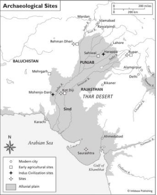
Sometime around 4000 B.C.E. a new ethnic group appeared in the Indus region, the Dravidians. Though thought to have come from the Middle East, their origins are unknown. Their appearance — not fair skinned, high nosed, or flat nosed — indicates they were not related to central Asians or Mongolians. Early urban centers began to appear in the area about this time. One such community, Rehman Dheri, a few miles north of Dera Ismail Khan in NWFP, had an estimated population of 10,000 to 15,000. Inscriptions found on pottery at the site indicate script was developing. Remnants of such settlements have been found from Sahiwal and Rupar in East Punjab to Karachi and Baluchistan to the west.
The Dravidians built planned towns with two-story buildings, underground drains, public water supplies and baths, and large grain storehouses. More than three dozen sites have been identified. After 4000 B.C.E. bronze, a combination of copper and tin, became common in present-day Pakistan, though stone tools remained the norm in Baluchistan.
By 3000 B.C.E. hundreds of farming communities were established along the Indus and its tributaries. Several towns were fortified. The wheel was in wide use, both for throwing clay on potter's wheels and on carts pulled by draught animals. Toy carts have been found in the ruins of Kot Diji and in surrounding areas of the Kot Diji culture. Examinations of the pottery found at various sites have led to specu- lation that much of the culture originated in farming settlements in Baluchistan and spread east.
The Indus Valley Civilization
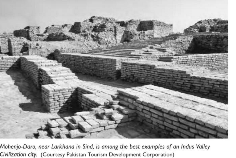
Sometime around 2600 B.C.E. at least two cities were destroyed by fire. In both cases, a new city was built atop the ashes of the old. But these new metropolises were markedly different from what they replaced. Both were built according to a uniform plan. Two large sites, Mohenjo- Daro (Mound of the Dead), near Larkana in Sind, and Harappa, near Sahiwal in the Punjab, are the most notable.
Mohenjo-Daro's edifices were constructed of durable burned-mud brick. Built around a central citadel, wide thoroughfares divided the municipal district into large blocks. Large temple-like structures include a pillared public bath measuring more than 100 feet by 180 feet. In residential areas, blocks were smaller and bisected by nar- rower lanes. Houses ranged from small cottages to roomy two- and three-story dwellings, replete with indoor plumbing. A complex sewer system, unmatched until the Roman Empire, served the city's sanitation needs.
Since these two cities were discovered in the 1920s, the remnants of many more built the same way have been uncovered. All have straight north-south and east-west streets. An administrative area was built on a vast platform protected by thick-walled fortifications overseen by watchtowers. Public buildings, granaries, and auditoriums also appear to have been common to all.
The Harappans were prosperous agricultural traders known through-
out the ancient world. They traded with Mesopotamia and with Arabian
Gulf communities. Internal trade likely consisted of cotton, lumber, grain,
livestock, and other comestibles. A highly standardized system of weights
controlled trade. The economic growth accompanying urban expansion
brought increasing social stratification and distinction. The appearance of
elaborate ornaments of gold, silver, and ivory; terra-cotta figurines; and
sculpture marked this evolution. They also produced finely painted pot-
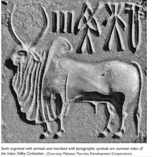
tery and carved seals similar to those found in Sumer. The seals were often
engraved with animals, the most common being a unicorn inscribed with
pictographic symbols. The symbology has yet to be deciphered.
Though peaceful, they also made weapons of bronze and stone. They worshipped many gods and goddesses, most prominently one similar to the later Hindu god Shiva. The dead were buried in wooden coffins with pottery vessels and simple ornaments. No elaborate or valuable items of gold, silver, or precious stones were interred with them.
The unity of style and symbology linked the region culturally but individual areas developed distinct, identifiable styles. At the end of the era these regional differences hardened, signifying independence as well as isolation, limiting the opportunities for advancement that had accompanied the earlier interaction.
At its height, the Indus Valley Civilization incorporated an area larger than Mesopotamia or Upper Egypt, stretching almost 700 miles (684 miles; 1100 km) north to south, from the foothills of the Siwalik Mountains to the Tapti River, and the same distance east to west, from Quetta in Baluchistan to Bikaner in Rajasthan, India, and Alamgirpur in the Upper Ganga-Jamuna doab.
Decline
After 1900-1800 b.c.e. the Indus Valley Civilization began to decline. Changes in river patterns wrought by earthquakes are thought to have contributed to the downfall of Harappan culture. While the Indus River is regarded as the wellspring for the region's earliest true civilization, at the time the region's greatest river was the Sarasvati, often identified in later Aryan accounts as the Ghaggar-Hakra. The Sarasvati River dried up and disappeared about 1900 B.C.E. , disrupting agriculture and the economy. The Indus changed course as well, causing destructive floods. The demise of the Indus Valley Civilization was mirrored in southeast Baluchistan, where settlements and irrigation systems were abandoned. Yet the area remained essentially habitable and hospitable, and the rea- sons for the depopulation are unknown. By about 1700 B.C.E. the Indus Valley Civilization had fragmented into smaller regional cultures called Late or Post-Harappan cultures.
The Aryans
A few hundred years after the urban centers of the Harappan culture had been abandoned, a people who called themselves the Aryans, or "noble ones" in Sanskrit, belonging to a large group of seminomadic tribes from Central Asia, migrated into the region. Before arriving on the subcontinent the larger group called Proto-Indo-Europeans had divided into three branches. One went west to Europe, the Iranian Aryans to Iran, and the third, the Indo-Aryans, to the subcontinent. Expert horse- men, aggressive fighters, and armed with iron weapons, the Aryans met little resistance. They arrived in the subcontinent in at least two major resettlements and ongoing, smaller migrations, the first in about 1,500 B.C.E. Their language, Dardic, or Old Indo-Aryan, composed of several dialects, was restricted to the Pamir mountain region at the time. The second wave came about six centuries later. In its aftermath their lan- guage, now evolved into Indie, became dominant in the Pakistan area. The Aryan language also became the root of Sanskrit, Pahlavi, Greek, Latin, and ancient forms of Teutonic and Slavic languages. By this time the Aryans had supplanted the Indus Valley Civilization. They may have driven the Dravidians south into what is now India.
The Aryans had chariots as well as weapons superior to those of indigenous forces. Aryans called those they conquered dasyus, meaning "inferior people born to serve." As Aryan society became more strati- fied, social laws evolved into a caste system of four classes. The highest were the Brahmans, priests who provided the link between men and god. Kshatriyas, the second caste, were warriors, commanders, lead- ers, and kings. The Vaishya caste consisted of artists, artisans, farm- ers, traders, and, later, minor officials. And the lowest caste, Shudras, were menial workers. Rule over Aryan tribes was primarily hereditary, though citizens had a voice through some elections. The king was crowned by Brahmans. The castes first developed as an open system, allowing Kshatriyas and Vaishyas to move up as their capabilities allowed. But over time the system became fixed.
The Epics
Knowledge of the Aryans primarily comes from their collection of sacred hymns, called the Vedas, meaning sacred knowledge. The Vedas include the Rig- Veda Samhita, Sama-Veda, Yajur-Veda, and Atharva- Veda. The Rig- Veda Samhita (Samhita means collection) is the source of all Vedic lore and religion. The Vedic pantheon contains 33 gods divided into groups of 11 in three categories: atmospheric (Indra), ter- restrial (Agni), and celestial (Surya or Vishnu). Reference to astronomi- cal phenomena leads scholars to believe the Vedas refer to incidents as early as 4500 b.c.e.
Two epic poems recount the heroic deeds of the early Aryans, and these traditions had a large influence on Hindu life and outlook. One, the Ramayana, was reputedly composed by Valmiki, a Hindu sage, although the date of its creation is unknown; the version that survives today is thought to date from between 500 and 100 B.C.E. The other epic, the Mahabharata, is a longer, episodic poem. The major portion of the Mahabharata is the Bhagavad Gita, a series of moral lectures from Lord Krishna to Arjuna, archer-prince, before going into battle.
Other sacred writings include the Brahmanas, commentaries on the Vedas that were written ca. 700-500 B.C.E.; and the Upanishads, con- sidered among the greatest religious works in the world. These latter writings represent the height of Hindu culture.
The language of the religious texts, Sanskrit, was sacred and per- sonified by a goddess. About 400 B.C.E. a grammarian, Panini, devel- oped some 4,000 rules for the language. Later the scholars Ktayayana (ca. 250 B.C.E.) and Patanjali (ca. 150 B.C.E.) wrote commentaries on Panini's work, adding to the codification of the rules of Sanskrit.
The religion was polytheistic, with gods representing the sky, sun, moon, thunder, rain, earth, and rivers. Indra, god of war, sacker of cit- ies, and bringer of rain, was the earliest of them and was originally the king of the deities. But over centuries a Hindu trinity emerged: Brahma, the creator; Vishnu, the preserver; and Shiva, the destroyer. Shiva ulti- mately evolved into both creator and destroyer. Vishnu was the savior of mankind.
Aryan Society
The basic Aryan political unit was the grama, or village, and its leader was the gramani. Ajana was a larger area, and a vis was likely a subdi- vision of a jana. Rashtra was the state and was ruled by a raja, or king, who was also called gopa, or protector. Samrat was the supreme ruler.
Early Vedic society was nomadic and cattle herding the chief occupa- tion. There were no coins or money at the time, and cows served as their currency. Families were patrilineal, with wealth passed from father to eldest son. The Aryan diet consisted primarily of grain and cakes, milk and milk products, and fruits and vegetables. Horse meat was consumed, but cows were seldom eaten due to their value, and their use as food declined over time.
Agriculture grew in importance and became the dominant economic activity as Aryan culture became more sedentary. Concurrently several small kingdoms emerged, often at war with one another. Some Vedic literature refers to 16 great kingdoms, or mahajanapadas. During this time two leadership groups emerged, the Brahmans and Kshatriyas. The former developed elaborate sacrifices and specialization, and proper enunciation of sacred verses became essential for divine intervention in granting wealth and victory in war. Over time the alliance between these two groups grew stronger.
From about 1500 to 1000 B.C.E. the area of present-day Pakistan where the Aryans ruled remained independent of the rest of what is now India. Once the Aryans migrated east to the Gangetic Plains, the area that is now Pakistan reverted to its insular existence. Little is known about the events that occurred in the region between 1000 and 500 B.C.E.
