Irrawaddy Division, 1908
This article has been extracted from THE IMPERIAL GAZETTEER OF INDIA , 1908. OXFORD, AT THE CLARENDON PRESS. |
Note: National, provincial and district boundaries have changed considerably since 1908. Typically, old states, ‘divisions’ and districts have been broken into smaller units, and many tahsils upgraded to districts. Some units have since been renamed. Therefore, this article is being posted mainly for its historical value.
Irrawaddy Division
Division of Lower Burma, occupying the south-west corner of the province, between 15° 40' and 18° 31' N. and 94° 11' and 96° d' E. On the north it is bounded by the Prome District of the Pegu Division ; on the east by the Tharrawaddy and Hanthawaddy Districts of the same Division ; on the south by the Bay of Bengal ; and on the west by the Bay of Bengal and the Sandoway District of the Arakan Division. With the exception of the Arakan Yoma running down the western border, the whole Division is an alluvial plain, watered by a maze of rivers and creeks, all taking off from the Irrawaddy. It is divided into five Districts : Henzada in the north, Ma-ubin in the east, Pyapon in the south-east, Myaungmya in the south, and Bassein in the south-west.
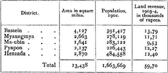
The population of the Division was 680,315 in 1872, 989,978 in 1881, 1,300,119 in 1891, and 1,663,669 in 1901. The greater part of this very large increase is due to the steady flow of immigration from India, and also from the Districts of Upper Burma. The distribution of population in 1 901 Ms given in the table below :—
The Division contains 7,185 villages and 16 towns. The head- quarters are at Bassein (population, 31,864), which enjoys easy rail- way communication with Henzada, and river communication with the other District head-quarters. The other chief towns are Henzada (population, 24,756), and Yandoon in Ma-ubin District (12,779), Bassein is a town of considerable historical importance ; but the Division as a whole never formed an independent political unit, and has taken no very prominent part in the events that have gone to mould the destinies of the people of Burma. The greater part of the population are Burmans, of whom there were 1,250,821 in 1901. Karens are well distributed throughout the Division, and in the same year numbered 299,119.
The Pwo and Sgaw Karens are most numerous in Bassein and Myaungmya Districts, and in 1901 showed totals of 142,495 and 52,072 respectively. Talaings (34,394 in number) are strongest in Ma-ubin and Pyapon Districts and weakest in Henzada. A certain number of Arakanese, Chins, and Shans are also found. Chinese in 1901 numbered 8,070, and the Indian population consisted of 30,639 Hindus and 18,944 Mu.salmans. The number of Christians (54,823) is large, owing to the numerous Karen population.
