Jullundur Division, 1908
This article has been extracted from THE IMPERIAL GAZETTEER OF INDIA , 1908. OXFORD, AT THE CLARENDON PRESS. |
Note: National, provincial and district boundaries have changed considerably since 1908. Typically, old states, ‘divisions’ and districts have been broken into smaller units, and many tahsils upgraded to districts. Some units have since been renamed. Therefore, this article is being posted mainly for its historical value.
Jullundur Division
Jalandhar____A Division of the Punjab, stretching from the borders of Tibet on the north-east across the valleys of the Upper Beas and Sutlej to the borders of the Bikaner desert on the south-west. It lies between 29 degree 55' and 32 degree 59' N. and 73 degree 52' and 78° 42' E. The Commissioner's head-quarters are at the town of Jullundur. The Division comprises all varieties of scene and soil, from the tumbled masses of the Outer Himalayas, in Kula and Kangra, to the fertile plains of Jullundur or the arid tracts of Feroze- pore. The population increased from 3,787,945 in 1881 to 4,217,670 in 1891, and to 4,306,662 in 1901.
The area is 19,410 square miles,
and the density of population 222 persons per square mile, as com-
pared with 209 for the Province as a whole. In 1901 Hindus formed
52 per cent, of the population (2,242,490), while other religions
included 1,457,193 Muhammadans, 591,437 Sikhs, 5,562 Jains,
4,176 Buddhists, 33 ParsTs, and 5,766 Christians (of whom 1,919
were natives). The Division contains five Districts, as shown
in the table on the next page.
Of these, Kangra lies entirely in the hills, sloping away to the sub- montane District of Hoshiarpur. The rest lie in the plains. The Division contains 6,415 villages and 37 towns, of which the following had in 1901 a population exceeding 20,000: Jullundur (67,735), Ferozepore (49,341), and Ludhiana (48,649). Besides the adminis-
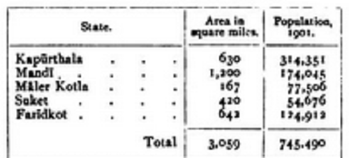
trative charge of these British Districts, the Commissioner has political
control over five Native States, which are shown below, with their area
and population : —
The total population of these Native States increased from 620,203 in 1881 to 709,811 in 1891, and 745,490 in 1901, of whom 52 ½ per cent, were Hindus (392,148), while other religions included 245,403 Muhammadans, 105,304 Sikhs, 1,993 Jains, 573 Buddhists, 4 Parsls, and 65 Christians. The density of the population is 244 persons per square mile. The States contain 1,053 villages and 12 towns, of which Maler Kotla (21,122) alone exceeds 20,000 inhabitants.
Ludhiana, Ferozepore, and Jullundur are the only towns of com- mercial importance, while Kangra and Jawala Mukhi are famous for their religious associations. The Division practically corresponds to the ancient Hindu kingdom of Trigartta. Kangra fort has been many times besieged, while more recent battle-fields are those of Mudki, Ferozeshah, Aliwal, and Sobraon in the first Sikh War (1845).

