Delhi: Flora, forests
This is a collection of articles archived for the excellence of their content. |
Contents |
Demarcation of forest areas
The Ridge

From: Jasjeev Gandhiok, Forest or not? No one knows the status in 10 out of 14 villages in southern ridge, February 15, 2018: The Times of India
While the National Green Tribunal has given a month’s time for the southern ridge to be demarcated completely, sources said the process to demarcate all fourteen villages may be completed only by the end of this year.
The revenue department began work on demarcating the southern ridge in August last year and only four villages — Rajokri, Ayanagar, Jaunapur and Ghitorni — have been handed over so far. The remaining 10 villages are currently being mapped and each village is likely to take close to a month to complete.
In 1996, Supreme Court had ordered protection of the Delhi ridge from encroachment. However till date, it has not been notified officially. While in 2014, the forest department had carried out its own survey and made digitised maps of the ridge, the revenue department had argued that these maps did not tally with their maps — thus making it difficult to identify encroachments. Forest officials say the demarcation will now ensure the ridge does not face any more encroachments in the future.
“Several cases in the NGT were stuck earlier as it was difficult to tell which parts had been encroached as we had no clear map. A house could be in the ridge according to one map or outside according to an older map. Thus, it was impossible to remove encroachments. Once this process is complete, we can fence these areas and drive out encroachers,” said a senior forest department official.
Sources said for the demarcated villages, fencing work is likely to begin soon following which they will be notified. According to the 1996 notification of the Delhi government, the 14 villages that fall under the southern ridge include Neb Sarai, Chhatarpur, Maidan Garhi, Dera Mandi, Asola, Pul Prahladpur, Devli, Rangpuri, Aya Nagar, Rajokri, Bhati, Ghitorni, Saidulajab and Jaunapur.
Teams from the forest and revenue department are mapping each village using a total station method, which tags the latitude and longitude, allowing officials to fence the area later. The department can then determine and remove any encroachments falling under it, a forest official added.
Forest cover
2001-2013

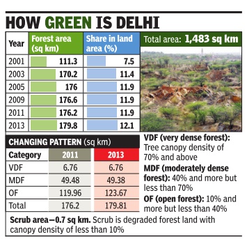
See graphic, 2001-2013: Delhi's forest area
2009-17
Jayashree Nandi, Your city has less than 1 tree per person, June 29, 2018: The Times of India
See graphics:
2009- 2017:
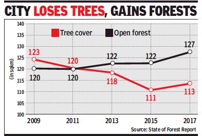
Tree cover in Delhi
Open forests in Delhi
2009- 2017:
Tree cover in Delhi
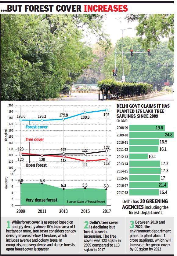
Forest cover in Delhi
Open forests in Delhi.
2008-17: saplings planted in Delhi.

Tree cover in Delhi
Open forests in Delhi
From: Dipak Dash, June 29, 2018: The Times of India

Tree cover in Delhi
Forest cover in Delhi
Open forests in Delhi.
2008-17: saplings planted in Delhi
From: Jayashree Nandi, Your city has less than 1 tree per person, June 29, 2018: The Times of India
BREATHING UNEASY: Tree Cover Steadily Down In Last 10 Yrs
Trees in Delhi — those along avenues, in colonies and at scattered lots — have been on a decline since 2005. The protests against tree felling for the redevelopment of seven south Delhi colonies may reflect the prevailing popular anxiety, but tree cover in the city went down from 123 sq km in 2009 to 111 sq km in 2015, before rising to 113 sq km in 2017, according to the Forest Survey of India’s State of Forest Reports.
The capital’s per capita tree cover stands at an abysmal 0.002 hectare. The Forest Survey of India (FSI) puts Delhi’s per capita tree availability at 0.3, or less than one tree per person. And while forest and tree covers cannot be directly compared, Russia’s per capita forest cover of 5.58 ha, Brazil’s 2.37 ha and United States’ 0.96 ha are suggestive of these cities being in a better situation. Forest cover in Delhi has gone up marginally since 2005.
FSI reports are based on data from two years prior to their publication. These, therefore, suggest that the loss in the city’s tree cover has taken place mainly in the 2005-15 decade. Tree cover reported in 2004 was even lower at 98 sq km.
The tree cover data takes tree density in cities and rural areas that are outside the protected forests. While forest cover is based on canopy density above 10% in an area of one hectare or more, tree cover considers canopy density in areas below that size. “Tree cover should be increasing in cities. It can be dynamic because these are not protected forests,” explained Prakash Lakhchaura of FSI. “There can be some change due to infrastructure projects, but the overall trend should be of a rise in tree cover.”
The declining tree cover means Delhiites are being exposed to dust and severe air pollution more than earlier. “Trees are excellent trappers of dust and carbon dioxide. Trees and vegetation are also crucial to minimise the impact of heat island effect, which not only increases local temperature but also causes a rise in emission of secondary pollutants like ozone,” said Anumita Roy Chowdhury, executive director, Centre for Science and Environment. For this reason, compensatory plantations created on the outskirts may not benefit city residents much.
The FSI data indicates an increase in open forests since 2005, but a gradual and marginal decline in very dense forest cover. Experts opined this could be attributed to the government’s compensatory afforestation projects. Interestingly, Delhi government claimed on Thursday that 176 lakh saplings have been planted in the capital 2009 onwards and the survival rate has been 65%.
Between 2018 and 2022, the environment department aims to plant one crore saplings to increase the green cover by 65 sq km. In doing this, experts advised considering the kind of species being planted. Efficiency of vegetation in assimilating pollution is determined by the shape and thickness of leaves. Native species are effective dust trappers.
“I have even seen the forest department planting champa, pongamia, royal palm and bougainvillea. These are not even trees. You need canopied trees to fight pollution,” said C R Babu, professor emeritus, Centre for Environmental Management of Degraded Ecosystems. “Yes, the forest department has created a city forest and some wooded lots, but it should focus on native species.”
2014-15: A Slight increase
The Times of India, Dec 05 2015
Slight increase in capital's forest cover The state of forest report 2015 shows that Delhi's cover has improved, but marginally . In terms of area, the increase is of about 9 sq km, making the total forest area about 20.29%. In the very dense forest category , there is an improvement of about 0.18% but there is a loss of about 0.71% in scrub forest which may be reflecting loss from Delhi Ridge.In the moderately dense fo rest category , there is an improvement of about 7.7% compared to the 2013, said the Survey of India report. There is also a reduction of about 8.5% in non-forest areas.
Forest department officials claimed it was a result of their sustained efforts. “Despite criticism and being labelled as a hindrance to development projects, we have proved our mettle,“ said an official. Experts, however, raised concerns about the decline in scrub cover.
==Forests in the NCR, district-wise, 2015==

See graphic, Protected forests in the NCR, district-wise, 2015
2017: cover is up 0.3% since 2015

From: Delhi’s forest cover is up 0.3% since 2015 but it’s nothing to cheer about, February 13, 2018: The Times of India
Dense Forests Have Recorded A Decline; Increase Only In Open, Scrub Forest Categories
Delhi’s forest cover has increased by 0.3%, or 3.6 sq km, compared to the assessments conducted in 2015, according to the State of the Forest Report 2017, which was released on Monday. But there is little to cheer about. The increase is only in the open and scrub forest categories whereas both very dense and moderately dense forests have recorded a decline.
The assessment by the Forest Survey of India emphasises Delhi is losing its dense, bio-diverse forests over the years even as plantations account for a minor improvement in the total forest cover.
As far as tree cover is concerned — sparse vegetation along roads or small-scale plantations — Delhi has the second-highest tree cover as a percentage of the total geographical area among states (see graphic). In this respect, Goa tops the chart. As far as forest cover is concerned, Delhi has lost about 0.2 sq km of very dense forest and 0.9 sq km of moderately dense forest since 2015. According to the report, the increase of 3.6 sq km observed in Delhi can be attributed to plantation activities and conservation whereas decrease in some areas could be because of developmental activities.
A senior forest official told TOI that the focus was on open areas this time around, instead of very dense forest (VDF) and moderately dense forest (MDF), which both came down slightly. “The overall increase in Delhi’s green cover is a good sign. Delhi’s green cover has increased from around 20.2% last time around to 20.6% this time. The fall in VDF and MDF areas could be due to development work, especially in the form of building roads, but the drop is not that significant,” the official said.
There is a 4.8 sq km increase in open forests and 0.7sq km in scrub forests.
There is another issue with FSI’s assessment of forest cover. According to forestry experts, the methodology for accounting forest cover doesn't differentiate between tree cover on agricultural land, plantations, urban parks and natural forests. The Forest Survey Of India defines forest cover to
be “all land more than one hectares in area, with tree canopy density of more than 10%, irrespective of ownership and legal status”. This definition could well mean that man-made forests are also counted as forests. In fact, the report clarifies that “occurrence of weeds like lantana in forest areas and agricultural crops like sugar cane, cotton, etc, adjacent to forest areas causes mixing of spectral signatures and often makes precise forest cover delineation difficult”.
The reduction in very dense and moderately dense forests in Delhi is all the more worrying because air pollution levels are extremely high in the capital — and getting worse. The carbon sequestration and pollution combating capacity of open forests is half or a third of that of dense, good quality forests, according to an earlier estimate by professor NH Ravindranath, a forestry expert from the Indian Institute of Science, Bangalore.
Green cover
Decline: 1986-2015
The Times of India, Aug 30 2015
Overall decline in green cover since 1986: Study
A recent study on the city's green cover shows a disturbing trend. Delhi's vegetation has seen an overall decline since 1986.The green cover is also increasingly becoming fragmented, the study reveals.The highest fragmentation is being seen on the periphery where afforestation work is being conducted to compensate for the loss of trees to urban development projects. However, it is also only on the periphery that the green cover is increasing while the same is on the wane in the core and transitional areas.
The study by Ashoka Trust for Research in Ecology and Environment (ATREE), Manipal Academy of Higher Education and Azim Premji University , highlights that though vegetation is increasing on the periphery, rapid urbanization and expanding real estate business could put this in danger. “Farm lands, wetlands, open spaces and trees on the periphery have been rapidly converted into urban built-up areas. With this, the vegetated landscape of Delhi is becoming increasingly fragmented like Shenzen, Daqing and Mumbai“ the study states.
For instance, the green cover in Delhi's core area in 1986 was about 64.68%, but it reduced to about 43.98% in 2010. Vegetation in the transitional area was 25.32% which marginally reduced to 22.43% but the peripheral green cover increased from 13.22% in 1986 to 16.52% in 2010.
“My study shows that there is an overall decline in the green cover in the past 25 years and the vegetated landscape is increasingly becoming fragmented. But when we look at different zones, we find that the core has maximum vegetation but it is also declining since 1986. The transitional zone has lesser proportion of vegetation than the core area. Though there has been a slight increase in the green cover in this zone from 1986 to 1999, the period between 2000 and 2010 saw a steady decline,“ said Somajita Paul, co-author of the study , which was conducted using satellite images for all these years.
Greenery, region-wise
July 30, 2018: The Times of India
Almost 50% of Lutyens’ zone and New Delhi is covered by greenery, while 32% of south Delhi has trees. On the other hand, east Delhi has only 5.13% green cover, west 5.29% and northwest 3.87%.
Flora, fauna native to Delhi/ NCR
Native species

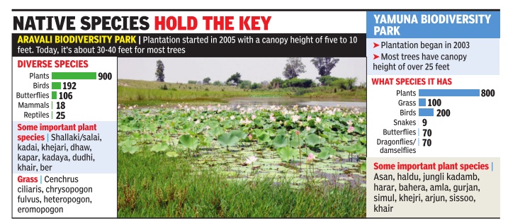
See graphic:
Species native to Delhi/NCR
Native trees

See graphic:
Brief list of selected native trees in Delhi
Trees
Definition of ‘tree’
Dipak Dash, July 23, 2018: The Times of India
What is a tree? This has become the hot subject of debate in government circles since the huge controversy of largescale felling of trees broke out in Delhi for redevelopment of seven residential colonies.
While Forest Survey of India (FSI) defines any woody plant with a height of 4.5 feet and a diameter of 10 centimetres as a ‘tree’, the Delhi Tree Act claims the definition for woody plants that are more than one feet tall and and with a diameter of five centimetres.
Sources said while the FSI norm of identifying a tree is followed by several states, there are others including Delhi, Uttar Pradesh, Uttarakhand and urban areas of Maharashtra which have their own norms. For example, as per the Maharashtra (Urban Area) Preservation of Tree Act, all perennial plants are treated as trees and in Rajasthan all plants including palms, bushwood and canes are treated as trees.
“The definition of tree differs from state to state. In Haryana, plants with 5 cm diameter are treated as trees. The original Indian Forest Act defined tree as a woody plant including palms, bamboos, skumps, brush-wood and canes. Bamboos were recently taken out of the list through an amendment in the law,” said a Haryana forest department official.
TOI tried talking to a couple of renowned experts to seek their views, but they refused to discuss the matter saying the definition of tree is a “controversial” issue. “There can’t be one-size-fits-all definition for trees as local conditions and requirement have been considered while specifying the norms,” a senior forest officer from Uttarakhand said. Some of the government officials said that the difference in the definition of trees has resulted in huge increase in the numbers of “trees” to be cut for infrastructure projects and hence there is a huge requirement of land to carry out compensatory plantation. The officials also said that as per the norms laid by the Delhi forest department, for each tree cut 10 trees needs to be planted whereas the forest ministry norms put this in the range of two to 10 trees for felling of each tree.
See also
Delhi: Flora, forests