Monsoons: India
(→Monsoons: date of arrival in various parts of India) |
|||
| Line 78: | Line 78: | ||
[[File: Delhimonsoon.jpg| The arrival of the monsoon in Delhi over the years|frame|500px]] | [[File: Delhimonsoon.jpg| The arrival of the monsoon in Delhi over the years|frame|500px]] | ||
'''See accompanying chart for Delhi''' | '''See accompanying chart for Delhi''' | ||
| + | |||
| + | = Years in which the monsoon arrived early = | ||
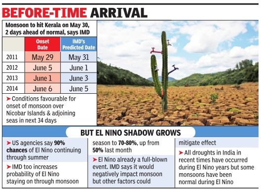
| + | [[File: years in which the monsoon arrived early.jpg|Years in which the monsoon arrived early: 2011-2014; Graphic courtesy: [http://epaperbeta.timesofindia.com//Gallery.aspx?id=15_05_2015_009_024_009&type=P&artUrl=Monsoon-may-be-early-but-El-Nino-fear-15052015009024&eid=31808 ''The Times of India'']|frame|500px]] | ||
| + | |||
=Monsoons in Punjab, Haryana= | =Monsoons in Punjab, Haryana= | ||
[[File: mosoon HP.jpg| |frame|500px]] | [[File: mosoon HP.jpg| |frame|500px]] | ||
Revision as of 22:20, 4 June 2015
This is a collection of articles archived for the excellence of their content. Readers will be able to edit existing articles and post new articles directly |
Contents |
Monsoons: India
Monsoon going strong, hopes soar
Rains Set To Cross 100% Of Long-Period Average, Record Rice Output Likely
Neha Lalchandani TNN
The Times of India 2013/08/02
A bountiful monsoon normally benefit the kharif crop and augurs good rice production with the area under sowing touching 196 lakh hectares in 2013, a 16 lakh hectare increase over 2012.
Monsoons that crossed the 100% mark
Since 1901, there have been 59 years when the monsoon has crossed 100% of the LPA. Since 2000, there have been only four years when monsoon crossed the 100% mark. These are 2003, 2007, 2010 and 2011. The projection is welcome news for the government as a stuttering monsoon can cast a long shadow on its political fortunes with growth slipping below 5% and high food inflation — prices for consumers rose 11.84% in June — proving a sizeable thorn in the side for UPA-2.
The government hopes the farm sector significantly improves on 2012’s 1.8% growth with R Rangarajan, chairman of the PM’s economic advisory council, saying a normal monsoon could even yield a 3.4% growth.
2013: Country sees wettest June-July in 19 yrs
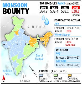
The June- July 2013 rainfall, which has been 117 % of the long period average [LPA] is the highest the country has seen since 1994. The last time there was more rain during this two-month period was in 1994, when the monsoon was 123% of the average. The 528.1mm rain bounty that the country got in the first half of the monsoon season is the third highest in 50 years. The wettest June-July spell during this period was in 1994 (564.7mm) while the second wettest was 1964 (538.1mm). Another interesting feature of this year’s rains has been the absence of a break in the monsoon ever since it covered the entire country in June 16.
Monsoons without a break
Non-stop monsoon marches on
Amit Bhattacharya TNN
The Times of India 2013/08/16
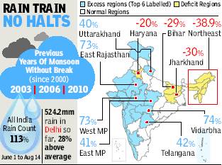
One or two periods of a break in monsoon — defined as three straight days of very low rain activity across central India — are common during the rainy season. Since 2000, there have only been three years when there was no monsoon break. And all three years coincided with plentiful rains.
“Two months of monsoon activity without a break is rather rare. It’s an indication of agood monsoon,” said M Rajeevan, senior weather scientist at the earth sciences ministry.
At least four factors have worked in favour of the monsoon in 2013. The first good sign was an absence of El Nino — an anomalous rise in ocean surface temperatures in the east Pacific that is linked to monsoon failure in India.
Currently, weak La Nina conditions exist in the Pacific, which is the opposite of El Nino and is known to help the monsoon here.
“Then, typhoons breaking out over the south Pacific this season have also helped because these have generally moved in a direction that reinforces the Indian monsoon. This is consistent with the weak La Nina conditions,” said Rajeevan.
More importantly, what has helped sustain the rains — and distribute it more or less evenly across the region — has been a series of low pressure formations over the Bay of Bengal that have travelled westwards at regular intervals.
“There have been an unusually high number of low pressure systems, along with cyclonic circulation over land. These have nurtured the monsoon this year, especially in the interior regions of south and central India,” said Pai.
Lastly, Pai said a strong Arabian Sea branch of the monsoon first helped accelerate the rain coverage over the country, and also brought good rains over the west coast.
Jun-Jul 2013: With 460mm rain, city’s wettest in 10 years
Amit Bhattacharya TNN
The Times of India 2013/08/04
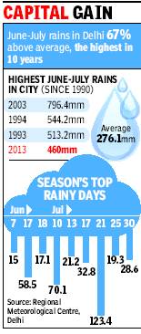
New Delhi: The first two months of the monsoon season have been wettest in the capital in the past 10 years. Delhi’s June-July rain tally stood at 460mm, 67% above normal, which is the second highest of this century after 2003.
The city’s rain aggregate got a huge boost in the second half of July. According to figures provided by the Regional Meteorological Centre, the capital got 238.9mm of rain during July 16-31, which is more than the average for the entire month.
There were 10 rainy days during this period, including the season’s wettest day (July 21), when 123.4mm came down on the city. This late surge lifted July’s rain tally to 340.5mm, 62% higher than the month’s average rainfall of 210.6mm. Since 1990, there have been only three years when the city has got more rain in June-July than this year. Apart from 2003, the other bountiful years were 1994 and 1993.
While the rain gods have been kind to Delhi, in neighbouring Haryana it’s been a different story. The meteorological district comprising Haryana, Delhi and Chandigarh is the only one in north India where rains have been deficient so far. That’s mainly because of poor rainfall in Haryana.
Monsoon break
A monsoon break — a period when rain activity comes to a stop in most of central India, the region where the monsoon trough is formed — is a common occurrence during the season. “The monsoon has been active without a break since mid-June. This does not happen often and is a reason why the rains were higher than the predicted 101% of LPA for July,” said D Sivananda Pai, IMD’s lead monsoon forecaster. (By Amit Bhattacharya)
Monsoons: date of arrival in various parts of India
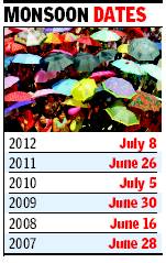
See accompanying chart for Delhi
Years in which the monsoon arrived early
Monsoons in Punjab, Haryana
16-year trend of poor monsoon in Punjab, Haryana
Amit Bhattacharya New Delhi The Times of India Sep 22 2014
India's bread basket states of Punjab and Haryana received just around half the normal rainfall this monsoon season. But more worryingly , this year's rain deficit is not an isolated event. The two key agricultural states have been getting below par rainfall for the past 16 years.
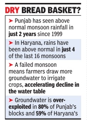
Met department figures reveal Punjab has seen above normal monsoon rainfall in just two years since 1999. The last time that happened was seven monsoons ago, in 2008.The stats are similar for Haryana, where rains have been above normal in just four of the last 16 monsoons.
Experts are divided over why rains have been consistently failing in the region but the trend has dire implications for agriculture, which relies heavily on groundwater. The two states are among the most exploited regions in the world for groundwater.
Deficient rains add another dimension to the crisis.Groundwater mainly de pends on rainfall for recharge. So, less rain means less groundwater availability .A failed monsoon also means farmers draw more ground water to irrigate their crops, particularly paddy , accelerating the fall of the water table.
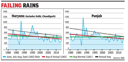
At TOI's request, Prof Krishna AchutaRao from IIT Delhi's Centre for Atmospheric Sciences plotted the annual and seasonal rainfall in the two states since 1980.The rain stats were obtained from the India Meteorological Department. A linear graph reveals a disturbing trend of decreasing rains in the bread basket of India. It shows average annual rainfall in Punjab falling during this period from just over 800mm in 1980 to less than 600mm in 2014 — a drop of roughly 200mm. Haryana’s annual average shows a similar drop, from around 780mm in 1980 to less than 580mm at present.
For monsoon season rainfall, Punjab has seen a drop of nearly 120mm, from an average of around 600mm in 1980 to roughly 480mm this year.
In Haryana, it’s down from more than 600mm to around 470mm during the same 35year period.
“The long term decrease in rainfall is apparent from the graph,” says AchutaRao, “although the rain statistics for the 1980s show very high variation.” But what’s not so apparent is the cause of the decline.
D Sivananda Pai, head of long range forecasting at IMD Pune, believes the drop is part of natural variability which will get reversed in time.
“Indian monsoon is passing through a low rainfall epoch since the 1990s. The drop in rainfall in this region could be part of that phenom enon,“ says Pai.
The story may not be that straightforward, says AchutaRao, who is coordinating multi-agency research into the Indian monsoon.
