National Capital Region (India): Disaster Management
This article has been sourced from an authoritative, official readers who wish to update or add further details can do so on a ‘Part II’ of this article. |
Contents |
The source of this article
Draft Revised Regional Plan 2021: National Capital Region
July, 2013
National Capital Region Planning Board, Ministry of Urban Development, Govt. of India, Core-4B, First Floor, India Habitat Centre, Lodhi Road, New Delhi-110003
National Capital Region Planning Board
National Capital Region (India): Disaster Management
BACKGROUND
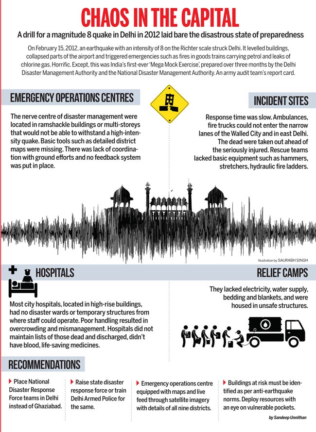
Geo-climate conditions and rapid development of National Capital Region (NCR) makes it vulnerable to disasters, both manmade disaster like fire, collapse of houses, CBRN, serial blast, road accident hazard, chemical or industrial accidents, environmental pollution, etc. and natural disaster like earthquakes, flood, etc. While floods, as a recurring annual phenomena, bring devastation in the region, earthquakes so far have caused higher casualties and emerged as a considerable threat. Development in NCR need to be planned taking care of the above natural hazards, besides taking other man-made hazards, specially fire into account.
The Report of Disaster Management in India, Ministry of Home Affairs, Government of India indicated that on an average, natural disaster take a toll of over 2198 human lives, damage 15 lakh houses and affects 42.47 lakh hectares cropped area during the period 2001-2011. Past statistics revealed that about 80% of human lives were lost, due to collapse of houses and buildings. This necessitates a comprehensive planning of building construction practices and natural disaster management framework for both postdisaster management and pre-disaster mitigation planning. While, earthquakes are not frequent phenomena but, they can unleash devastation instantaneously in large areas. The unpredictability of earthquakes require special disaster management framework.
15.2 VULNERABILITY AND RISK ASSESSMENT OF NCR DUE TO NATURAL HAZARDS
The major hazards associated with the earthquakes may possibly affect NCR are ground motion, which shakes structures causing them to collapse; liquefaction may also cause damage to the structures in some part of the NCR. Earthquakes sometimes also cause fire due to broken gas and power lines, and the destruction of lifelines such as water supply, power, gas, communication, roads, bridges, etc. utilities make difficult for the firefighters to reach the site which makes the situation worse. Wind, flood and fire also affect the buildings and structures resulting in loss of lives and properties. Similarly, the region lies in the flood prone area and inundation during monsoon is a regular feature. As per the past history of the floods in the Ganga and Yamuna sub-basins, the districts affected are Meerut, Ghaziabad & Bulandshahr in U.P. and Rohtak, Panipat & Sonepat in Haryana. The vulnerability Atlas of India, published by Building Material and Technology Promotion Council (BMTPC), Ministry of Urban Development indicates that National Capital Region falls within: i) High damage risk zone-IV of the Seismic Zoning map of the country (expected MSK intensity VIII) with regard to earthquake. ii) Very high damage risk zone B (Vb = 50m/s) with regards to wind and cyclone hazard and iii) Areas liable to floods
15.2.1 Earthquake
National Capital Region (NCR) is located on folded crustal ramp with basement rocks of Delhi Super group, bounded by two regional faults viz Mahendragarh-Dehradun Sub Surface Fault ( MDSSF) in the west and Great Boundary Fault (GBF) in the East Delhi. The ramp trending NNE-SSW across ‘fore deep’, is juxtaposed to Himalayan thrust belt. Another important structural element of the belt is NW-SE trending Delhi-Sargodha Ridge (DSR) which passes through Delhi and is flanked by basins on either side, viz Sahaspur Basin in the north and Bikaner Basin in south west. The geotechnical mapping, geophysical survey and remote sensing studies have indicated presence of many lineaments around Delhi. Geological Survey of India compiled a Seismotectonic Atlas based on review of seismotectonic of the country and published in 2000 (GSI 2000). As per this Atlas, fault lines of consequence in the domain having been defined in unanimity are
(i) Great Boundary Fault (GBF),
(ii) Mahendragarh- Dehradun Sub Surface Fault (MDSSF),
(iii) Moradabad Fault,
(iv) Delhi Sardodha Ridge (DSR),
and some highlighted importance of
(v) Sohna Fault and
(vi) Mathura Fault
Delhi and its environs have been damaged by earthquakes from far field seismic source in Himalaya,
namely Great Kangra Earthquake of (M: 8.0, 1905, IX) and Uttarkashi (19th Oct., 1991) shocked Delhi
to the extent of intensities VI and V respectively. The felt intensity of the Chamoli earthquake
(28th March, 1999) was VI at Delhi, about 300 km from the epicenter and the peak ground acceleration
value recorded near Delhi was about 11 cm/sec2. In addition to this, Delhi domain has also been affected
by earthquakes of local fault systems of peninsular domain. The history of past earthquakes experienced
in and around Delhi shows that it is situated in region liable to moderate damage by earthquake. Six
historical earthquakes of magnitude 5.5 to 6.8 are known to have occurred in NCR and its surrounding
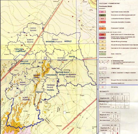
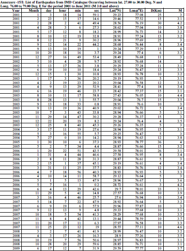
area since 1720 AD, as detailed in Table 15.1. List of earthquake greater than 3 recorded in NCR during
2001 to June 2011 is at Annexure-15/I.
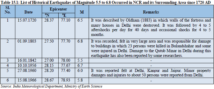
Reports indicate that recently an event of magnitude ML = 4 occurred on 28 July 1994, caused minor damage to the minarets of Jamma Masjid. During last decade (2001-June 2011), sixty four earthquakes of magnitude between 3.0 to 4.6, have occurred in NCR region. Among these sixty four earthquakes, six were of magnitude M ≥ 4 and the earthquake of maximum magnitude 4.6 was recorded on 25.11.2007. The epicenters for these earthquakes ( M ≥ 3) were located in NCR, as shown in Map 15.1: National Capital Region: Seismo-tectonic Features.
Magnitude Earthquake Effects
2.5 or less Usually not felt, but can be recorded by seismograph.
2.5 to 5.4 Often felt, but only causes minor damage.
5.5 to 6.0 Slight damage to buildings and other structures.
6.1 to 6.9 May cause a lot of damage in very populated areas.
7.0 to 7.9 Major earthquake. Serious damage. 8.0 or Greater
Great earthquake. Can totally destroy communities near the epicenter.
The seismic vulnerability of built environment of NCR need to be examined vis-a-vis high frequency ground motions due to events endemic to faults of Peninsular Domain capable of producing earthquake of magnitude around 6.5 to 6.7 and also due to frequency content of attenuated events with source zone in thrust domain of Himalayas capable of producing earthquake of magnitude around 8.0.
National Capital Region falls in Seismic Zone IV of the Seismic Zoning Map (BIS IS 1893, Part 1:2002) of the country. This makes the area liable to experience MSK intensity of ‘VIII’ and is considered as High Risk Zone. Such intensity may cause severe damages to the structures of different types. Some of them are listed below:
• Type A- Houses constructed with stone, rural structures, un-burnt bricks, clay, etc. may suffer destruction causing gaps in walls, collapse of parts of buildings, loosing of cohesion of part of buildings and collapse of inner walls.
• Type-B- Building constructed with ordinary bricks, large blocks, natural stone and prefabricated type buildings may suffer heavy damage causing large & deep cracks in walls.
• Most buildings of Type-C i.e. RCC buildings may have small cracks in walls, fall of large pieces of plaster, slipping off tiles, cracks/fall in chimneys, etc.
• Fright and panic is caused among people,
The approximate area subjected to damaging intensities MSK, VIII and VII in five earthquakes of magnitude around 6.5 occurred in different part of the country are as given in Table 15.2.
- Medvedev-Sponheuer-Karnik (MSK) scale has 12 intensity degrees expressed in Roman numerals starts from I (Not perceptible) to XII (Very
catastrophic)
Considering the areas affected during past earthquake of magnitude 6.5, it can be expected that such an earthquake occurring in NCR could adversely affect the entire region with damaging intensities and could affect more than 50% of Central NCR depending on the location of the epi-centre. Therefore, in terms of probable damage scenario, the National Capital Region is most prone to earthquake. The whole urban development in the region must be checked for safety against a probability of occurrence of seismic intensity “VII” and upgraded for required seismic resistance in buildings and infrastructure as found necessary to withstand minimum Peak Ground Acceleration value of 0.24g.
Zone V
MSK IX or more Very High Damage Risk Zone All surface and underground structures completely destroyed.
Zone IV
MSK VIII High Damage Risk Zone Waves may be seen on very soft ground. Older structures partially collapse or sustain considerable damage
Zone III MSK VII Serious damage to older buildings, masonry chimneys collapse. Small landslides.
Zone II MSK VI or less Low Damage Risk Zone Visible damage to masonry structures, cracks in plaster. Isolated cracks on the ground.
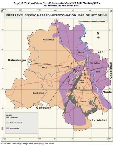
The Seismic Hazard Microzonation (SHM) provide basic input for further study of Seismic Hazard and Risk Microzonation (SHRM) and is one of the important tools for disaster mitigation planning for urban areas, as it can minimize disaster impacts of an earthquake. Seismic Hazard and Risk Microzonation provides (a) Probabilistic estimate of earthquake hazard at each microzone on earthquake shaking,
(b) Extent of likely damage to built environment (dwellings, community structures, lifelines, industrial structures, monuments and heritage structures) and define damage ratio and people living in structures susceptible to damage,
(c) Measures for retrofitting of existing structures to render them safe and (d) Specific guidelines for designing and construction of earthquake resistant structures in different microzones. Seismic Hazard microzonation is basically determination of frequency dependent transfer function due to impedance contrast between bedrock and overlying soil at the site and will provide site specific parameters for design of buildings. This would be helpful for identifying areas of low and high hazard zone, suitable area for different types of constructions i.e. Low and high rise, etc. Thus this study will be helpful for micro level planning of urban agglomeration.
15.2.2 Floods
The main causes of floods are heavy rainfall, inadequate capacity of rivers to carry the high flood discharge, inadequate drainage to carry away the rainwater quickly to streams/rivers, flash floods occur due to high rate of water flow as also due to poor permeability of the soil. Vulnerability to floods is caused by the high population density, widespread poverty, unemployment, illiteracy and enormous pressure on land. One of the reasons for damage of property and life by floods is development of slums/ unauthorized construction in High Flood Level area. Flood results in the outbreak of serious epidemics specially, malaria and cholera, simultaneously, scarcity of water. To manage these serious issues, NDMA has prepared guidelines on Management of Floods wherein measures for preparedness, prevention, mitigation in the pre-flood stage and on prompt and effective response, relief and recovery during and post flood stages have been focused. Importance on non-structural measures besides structural measures is emphasized in the guidelines. Setting of basin-wise organizations for flood management and also for setting up a National Flood Management Institute for training, education and research are suggested in the guideline.
As per the Flood Atlas of India prepared by Central Water Commission, only small portion towards the south-east in Delhi is unprotected flood prone area (about 1.7% or 25 sq.km.) and considerable area (about 5% or 74 sq.km.) in the north-eastern parts which is protected by earthen embankments. Map of flood prone areas in NCR is given in the Water Chapter. Flood levels in Yamuna cross the danger level almost every year and people living in low lying areas behind the ‘bunds’ (embankments) are forced to evacuate to the top of the bunds or on road sides at higher elevations. The flow and the expected flood levels of the river Yamuna at Delhi is forecast by the Central Water Commission through hydrological and hydraulic observations on the upstream, particularly taken at
Hathnikund headworks about 130 km upstream from where two canals take off from the Yamuna,
one on its left bank Western Yamuna Canal (WYC) and the other on the right bank Eastern Yamuna
Canal (EYC). Since the Hathnikund Barrage/headworks and the two canals have limited capacity, in
the event of heavy precipitation in the catchment area of Yamuna and its tributaries, the river
downstream comes in spate, overflowing its banks and flooding the adjoining low lying areas. Also
great damage is caused to areas deep inside the region because of the back flow in the drains which is
otherwise meant to discharge excess water into the river. In addition, heavy precipitation within the
region causes local flooding of streets and localities on a large scale.
In recent years even moderate
rainfall has resulted in local floods. Main reason for these local floods is high rate of runoff from
urban areas which have been continuously growing at a very rapid rate. This problems of local floods
is expected to aggravate in NCR because, almost the entire area is likely to get urbanized leaving
very little scope for open and soft landscape surfaces, which help in absorbing runoffs and soften the
impact of floods.
15.2.3 High Winds
The macro-level wind speed zones of India have been formulated and published in IS: 875 (parts) - 1987 titled " Indian Standard Code of Practice for Design Loads (other than earthquakes) for Building and Structures, Part 3, Wind Loads". As regards to wind hazard, design wind speed in the entire region is 47 m/s (169 km/h) as per IS 875 (Part 3), which could be reached only occasionally in what is called ‘Andhi’ (wind storm). However, the NCR area falls in Very high damage risk zone B (Vb = 50m/s). The structures in this region should be designed keeping in view the above wind speed. In such events, weak houses of thatch, sheets etc. and those with sloping roofs using thatch, tiles, AC sheets and Corrugated Galvanized Iron (CGI) sheet roofs, which are not fully anchored and integrated, will suffer damage. During the summer season, extreme positive departures from the normal maximum temperature result in a heat wave. The flow of hot waves is also known as ‘loo’. Generally heat waves develop in the northwestern parts of India and from this area they progress to neighbouring states. Table 15.3 gives the number of heat waves observed in the NCR participating States during 1911-2009:
Wind Speed,
m/sec
Typical Possible Movement
30-35 Roof sheets fixed to battens fly
35-40 Small aircrafts take off speed
40-45 Roof tiles nailed to battens fly
45-50 Garden walls blow over
50-55 Unreinforced brick walls fail
55-60 Major damage from flying debris
60-65 75 mm thick concrete slabs fly
Source: Report on Guidelines for cyclone resistant construction of Buildings in Gujarat prepared by Gujarat State Disaster Management Authority, Govt. of Gujarat
The Table 15.3 indicates that the Rajasthan and Uttar Pradesh are more affected by heat waves. Prolonged severe heat wave condition may cause serious problems to water supply, moisture stress in the soil and adversely affect agriculture. When an area is affected by severe heat wave and also followed by delayed onset of monsoon, then the situation becomes more miserable for the inhabitants because of water scarcity and delay in sowing operations. The casualties due to heat waves were found maximum in Rajasthan followed by Uttar Pradesh, Haryana and Delhi. It may also be noted that loss of human lives in a region due to heat waves is not only depend on the number of waves spells but also on the socio-economic condition of the people. This wind scenario does not cover the risk of tornado, which is a seldom case in respect of its occurrence, intensity and path, and is extremely difficult to deal with in general hazard risk studies. Also, in any one wind storm, it is unlikely that the whole or a large part of Delhi will be affected at once, and neither is there any possibility of a disastrous consequence from this hazard. 15.3 VULNERABILITY AND RISK ASSESSMENT OF THE REGION DUE TO MAN MADE HAZARDS Rapid urbanization and industrialization are forced to adopt new approaches for Socio-economic development. Increased population density and mixed occupancy, construction of high rise buildings having multi activities, roads, industries are the major development activities which causes Man made hazards like fire, Chemical, Biological, Radiological, and Nuclear (CBRN) hazards, road accidents, etc..
Fire Hazard
Fire hazards in NCR can be attributed to following main reasons:
• Non-implementation of fire safety norms as part of building bye-laws.
• Encroachment, overcrowded and haphazard growth affect the movement and timely approachability of fire tenders in emergency.
• Inadequate safety measures in the electrical installation
• Sub-standard wiring and over loading of electrical system.
• JJ clusters constructed with highly flammable material and some constructed with very toxic materials like plastics, polyethylene sheets, bamboo, soft wood etc. without proper access for fire tenders.
• Storage of flammable/explosive material in the vicinity of populated area and hazardous commercial activities;
• Inadequate pumping facilities hamper fire fighting and control of fire.
• Inadequate availability of special fire fighting equipments with local bodies especially for high rise multistoried buildings, where it is a prerequisite.
A comprehensive study of the vulnerability due to fire hazards in the region and in different areas of fast growing towns should be taken up and adequate safety provisions be made for future planning of NCR and improvement in the quality of electrical cabling, wiring and distribution systems should be made.
15.3.2 Chemical, Biological, Radiological, and Nuclear (CBRN) Hazard
The CBRN scenario gains importance because in recent past, a number of CBRN incidents such as Chemical (Bhopal Gas Tragedy, 1984), Nuclear (Bulandshar, U.P., 1993), Biological (Plague in Surat, 1994), Radiological (Cobalt-60 in Mayapuri, New Delhi 2010) and Nuclear (Fukushima, 2011) have taken a heavy toll on human life and economy in urban settings. The incidents in Nuclear Facilities in NCR are given in Table 15.4:
CBRN hazards may arise in a number of ways, such as- • Explosion in a plant • Accidents in storage facilities of chemicals • Misuse of chemicals • Improper waste management • Technological system failures • Human error
For the purpose of specialised response to a threatening disaster situation or disasters/emergencies both natural and man-made such as those of CBRN origin, the Disaster Management Act, 2005 has mandated the constitution of a National Disaster Response Force (NDRF). The NDRF comprises eight battalions. These battalions are located at strategic locations and will be deployed proactively as required. Presently four out of eight of them have been equipped and trained to respond to situations arising out of CBRN emergencies. One such battalion is located in Greater Noida in NCR which cover States of U.P., Uttarakhand, Haryana, Delhi, Chandigarh, Punjab, J&K and Himachal Pradesh while Rajasthan state is covered by NDRF Battalion located in Gandhi Nagar (Gujarat).
