Bio-diversity in Jammu, Kashmir, Ladakh: Cultural and Historical Background
This article has been sourced from an authoritative, official readers who wish to update or add further details can do so on a ‘Part II’ of this article. |
Contents |
The source of this article
Bio-diversity in Jammu, Kashmir, Ladakh
By the Department of Forests, Government of Jammu and Kashmir
The three regions of Jammu, Kashmir and Ladakh were brought together under a single state in 1846. Kashmir has a very ancient history reflected in historical accounts and discussed in famous ‘Rajtarangni’. As part of Ashoka’s Empire and Kushan Empire, it was flourishing center of Buddhist culture for many centuries. The ruins of impressive temples at Martand, Pattan and Avantipora bear testimony to the great Hindu culture under the Hindu dynasties that flourished till 14th century. The most famous of the Hindu kings was Lalitaditya.
Islam came to Kashmir much later when a series of preachers from Iran and Central Asia entered here. Sultan Zain-ul-Abidin who ruled for the 1st half of the 15th century was tolerant towards Hindu religion, he is credited with the introduction of many arts and crafts including shawl and carpet weaving, wood carving and paper mache work. Akbar the great conquered Kashmir in 1585 and it became a favorite resort for the Emperor Jahanghir. It was during the empire of Jahanghir that foundation of World famous Mughal Gardens was laid and the grandeur persists to the present times.
Ladakh was an independent country before 10th century A.D. the ruling Tibetan dynasty remained preacher of Buddhism and Ladakhi culture developed on its own as an offshoot of that of Tibet. The Central Asian Merchants and other missionaries added Islamic culture in the area. By the 18th century the Drass and Purig areas of western Ladakh became Muslim dominated though central Ladakh, Nobra and Eastern Areas retained the older faith of Buddhism. Ladakh’s prosperity was based largely on trade which was carried out through the ancient silk route. It was the only channel for the supply of pashm (pashmina) produced on its own pastures.
The Jammu region was initially a cluster of small Himalayan kingdoms until these got consolidated under a single political unit by the Dogra Chief, Maharaja Gulab Singh and his brothers. Jammu town acquired importance for the trade in Kashmir Shawls and other commodities during 18th century which led to decay of Lahore – Delhi route. The Shawl merchants preferred to cross the Banihal-pass to enter into Jammu markets and reached as far as Moradabad. In 1834 Gulab Singh sent an army to invade Ladakh and he concurred Baltistan adjoining Ladakh down the Indus river. Four years later by the treaties of Lahore and Amritsar the British recognized Gulab Singh as ruler of Kashmir as well as of Jammu and Ladakh in consideration of his paying half of the indemnity of 1.5 crore Rupees. Thus the state of J&K as we know presently came into existence.
A century later and immediately after the independence and partition raiders from Pakistan invaded Kashmir in an attempt to take it by force but the then Maharaja Hari Singh of the state supported by the National Conference and the Government of India failed their evil designs and signed the Instrument of Accession with India. In 1957 the Kashmir Assembly confirmed the Instrument of Accession by declaring the State as an integral part of India. Pakistan has however never accepted this position and fought three major wars in 1947, 1965 & 1971 and has been badly defeated. Now Pakistan is engaged in proxy war by sending trained and armed militants who are killing innocent people and destroying property and assets of the state. Because of the prevalent disturbed conditions many of the developmental projects have suffered a set-back and economy of the state has also been badly affected.
Geographical Profile
Area & Location
The state of Jammu & Kashmir is located in the North-western part of Indian Republic and lies between 32°-17’ and 37°-5’ North latitude and 73°-26’ and 80°-30’ East longitude and holds an almost central position in the continent of Asia. It occupies about 6.74 percent of the total area of the country and has a total geographical area of 222236 square kilometers. Out of this total geographical area of the state 78114 sq. kilometers is under illegal occupation of Pakistan and 42735 square kilometers under China.
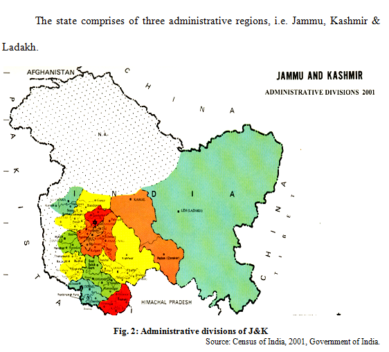
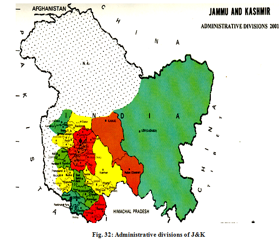
The state comprises of three administrative regions, i.e. Jammu, Kashmir & Ladakh.
Physiography, Relief and Drainage
The J&K region consists of four great mountain ranges of Himalayas, the Karakoram, the Ladakh, the Zanskar and Pirpanjal. Between these ranges are the longitudinal valleys of Gilgit, Shyok, Indus and Jehlum. South of Pirpanjal is the Shivalik range comparatively much lower in elevation and known as Jammu hills. Further south there is a narrow strip of foot hill plains (25 kms vide) merging into Punjab plains.
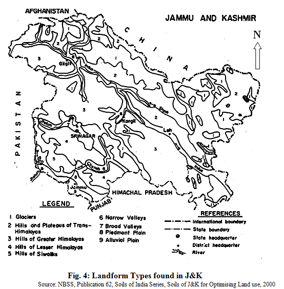
The state is divided into 5 physiographic regions i.e. Trans Himalayas, Greater Himalayas, Lesser Himalayas, Shivaliks and Plains which have been further divided into 9 land forms and they are enumerated below:
1. Glaciers
2. Hills and Plateaus of Trans-Himalayas
3. Hills of Greater Himalayas
4. Hills of Lesser Himalayas
5. Hills of Siwaliks
6. Narrow Valleys
7. Broad valleys
8. Piedmont Plains
9. Alluvial plain.
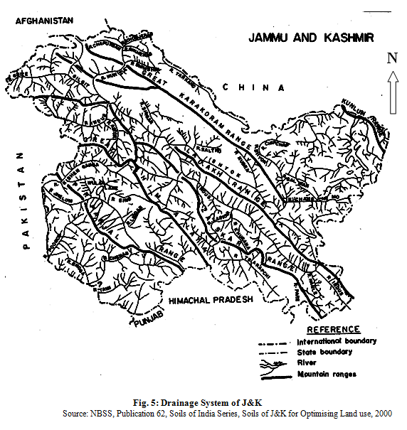
Ladakh region is drained by river Indus and its tributaries like Shyok, Shigar, Gilgit and Astor. Jhelum river drains out valley of Kashmir while the Chenab river drains the eastern section of southern slopes of the Pir Panjal, Jammu hills and the foothill plains. The parts of Jammu region adjoining Punjab and Himachal Pradesh are drained by river Ravi and its tributaries such as Tawi, Munawer Tawi etc. Drainage system of the state is given below:
Table 1: Geographical Area & Forest Area of J&K |
||||
|
S.No. |
Division |
Geographical Area in Sq. Kms |
Forest Area in Sq. Kms. |
Forest Area Percentage |
|
1. |
<st1:City w:st="on">Jammu</st1:City> |
26293 |
12050 |
45.83 |
|
2. |
<st1:place w:st="on">Kashmir |
15948 |
8115 |
50.88 |
|
3. |
Ladakh |
59146 |
17 |
0.03 |
|
4. |
Area under illegal occupation of <st1:place w:st="on">Pakistan |
78114 |
- |
- |
|
5. |
Area under illegal occupation of <st1:place w:st="on">China |
42735 |
- |
- |
|
Total Area |
222236 |
20182 |
9.08 |
|
Source: Forest Statistics Digest
The state of Jammu & Kashmir is mountainous and shares international boundaries with Pakistan in the west, Chinese autonomous regions of Xinjiang in the North and Tibet to the North East. It is connected to the rest of the country through a 30 Km long boundary with Punjab and 300 km long boundary with Himachal Pradesh. The state has three main territories of Jammu, Kashmir and Ladakh that differ in terms of climate, topography, flora, fauna, ethnic groups, religious and cultural traditions and local health practices.
Table 2: The characteristic features of 3 regions of J&K
|
Physiographic region |
<st1:City w:st="on">Jammu</st1:City> |
<st1:place w:st="on">Kashmir |
Ladakh |
|
Altitude |
300-4000 m |
2000-5000 m |
4000-6000 m |
|
Annual rainfall |
1148 mm |
664 mm |
115 mm (Leh) 757 mm (Drass) 306 mm (Kargil) |
|
Vegetation |
Sub tropical dry deciduous forests and coniferous forests |
Moist temperate and alpine vegetation |
Cold desert scrub vegetation |
|
Water availability |
Moderate to Scanty |
Moderate |
Scanty |
|
Local Ethnic groups |
Dogras, Chibhalis, Gujjars, Bakker-wals, Gaddis, |
Kashmiris, Hanjis, Gujjars, Bakkerwals. |
<st1:City w:st="on">Mons</st1:City>, Drokpas, Changpas, Amchis, Balti, |
|
Language |
Dogri, Gojri, Pahari, Kashmiri, |
Kashmiri, Gojri, Pahari, |
Ladakhi |
|
Population |
3537957 |
4210202 |
170541 |
|
Districts |
6 |
6 |
2 |
Source: Forest Statistics Digest.
Geology
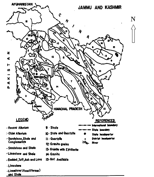
The region represents mixed geological formations ranging from Archacans to recent. Crystalline rocks like granite and gneisses of Archacan age occur mainly in the Zanskar range, Gilgit, Baltistan and Ladakh. Slates, phyllites, schists, quartzites, crystalline limestone and dolomites are found to occupy the tracts of west Ladakh, north Hazara, Gilgit and Zanskar range. Limestone and shales are found extensively in the Karakoram range. Dogra slates and quartzites occur in the south-west flanks of Pir panjal.
Shiwalik hills dominantly occupy Jammu region and are composed of sandstones, shales and conglomerates. Foot-hill plains and valleys are formed from alluvium deposits. The geological map of the state is given below:
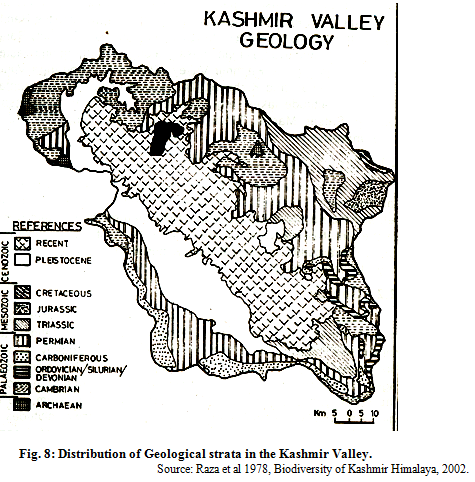
The distribution of Geological strata in the Kashmir Valley is reproduced as under:
Climate
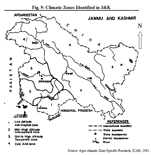
The climate of Jammu and Kashmir varies from sub-tropical monsoon type of Jammu, cold temperate of mountainous regions of Kashmir & Jammu to cold desert conditions of Ladakh. The climate of Jammu is characterized by Hot summers and cold winters with heavy rainfall during August & September months, The climate of Kashmir is of cold temperate type with heavy precipitation during winter months and spring season. The climate of Ladakh is of extreme cold type with almost negligible annual precipitation. After a gap of three years, Ladakh region has experienced snowfall in the month of March this year. There are considerable differences in weather conditions from season to season with extreme hot summers and severe winters in Jammu province; mild summers and chilled winters in Kashmir and mild summers to extremely freezing winters in Ladakh with freezing temperatures falling down to –45° C in Dras and Changthang areas. The annual rainfall of Jammu province varies from 800 mm to 4000 mm in different regions, the annual rain fall of Kashmir varies from 500 mm to 2500 mm. Five broad macro-climatic zones stands differentiated as sub-tropical, valley temperate intermediate, Dry temperate and cold arid types.
1. Sub tropical Zone: The parts of Jammu, Kathua, Udhampur, Poonch and Rajouri Districts have sub-tropical climatic zones with mean hight above the sea level ranging from 300m to 1350 metres having hot summers and dry pronounced winters with heavy rainfall during monsoon months.
2. Valley temperate Zone: This zone covers many parts of Kashmir valley and inner Himalayan areas with average height ranging from 1560 m. to 4200 m having wet and cold winters and relatively dry and moderately hot summers.
3. Dry temperate: The parts of Rajouri and Doda districts having altitudinal variation from 1350 m to 3000 m with relatively wetter and colder weathers and monsoon rainfall in Aug-Sep. months.
4. Cold Arid zone: This zone covers the districts of Ladakh and Kargil in the East and Gilgit and adjacent areas in the North-west. The altitude ranges from 7200 m to 8400 m. Winters are exceptionally cold and dry and summers are moderately hot and dry.
5. Intermediate zone: This zone covers mid and high altitude areas of Doda, Poonch, Rajouri and Udhampur Districts where rainfall pattern resembles closely to that of the valley temperate zone but the summer rainfall resembles the precipitation pattern of the sub-tropical zone.
Table 3: Zone Wise Climatic Features of the State.
|
Month |
Mean Rainfall |
Mean Temperature °C |
Thermal Index |
Hydrological Index |
A. Tropical Zone |
|
|
|
|
|
January |
58 |
13.6 |
Cold |
Humid |
|
February |
62 |
15.5 |
Cold |
Sub-humid |
|
March |
52 |
20.0 |
Mild |
Sub-dry |
|
April |
33 |
26.4 |
Mild |
Dry |
|
May |
24 |
3.1 |
Very hot |
Dry |
|
June |
71 |
33.6 |
Very hot |
Dry |
|
July |
325 |
30.8 |
Very hot |
Humid |
|
August |
299 |
20.3 |
Very hot |
Humid |
|
September |
84 |
28.0 |
Very hot |
Sub-humid |
|
October |
18 |
25.4 |
Hot |
Dry |
|
November |
17 |
19.5 |
Cold |
Dry |
|
December |
32 |
14.5 |
Cold |
Dry |
|
Annual (Mean) |
89.08 |
24.2 |
Mild |
Humid |
B. Valley Temperate Zone |
|
|
|
|
|
January |
74 |
1.2 |
Very cold |
Very humid |
|
February |
72 |
2.7 |
Very cold |
Very humid |
|
March |
92 |
8.3 |
Very cold |
Very humid |
|
April |
93 |
12.9 |
Cold |
|
|
May |
60 |
17.6 |
Mild |
Sub humid |
|
June |
36 |
21.9 |
Mild |
Dry |
|
July |
59 |
24.5 |
Hot |
Sub dry |
|
August |
61 |
23.9 |
Hot |
Sub dry |
|
September |
39 |
20.3 |
Mild |
Dry |
|
October |
30 |
14.0 |
Cold |
Sub dry |
|
November |
11 |
8.5 |
Cold |
Dry |
|
December |
34 |
3.6 |
Very cold |
Humid |
|
Annual (Mean) |
50.00 |
13.3 |
Cold |
Humid |
C. Dry Temperate Zone |
|
|
|
|
|
January |
58 |
13.6 |
Cold Humid |
|
|
January |
6 |
4.0 |
Very cold |
Dry |
|
February |
7 |
7.1 |
Very cold |
Dry |
|
March |
20 |
12.1 |
Cold |
Dry |
|
April |
24 |
16.9 |
Cold |
Dry |
|
May |
20 |
21.9 |
Mild |
Dry |
|
June |
9 |
26.6 |
Hot |
Dry |
|
July |
10 |
28.7 |
Very hot |
Dry |
|
August |
14 |
27.9 |
Hot |
Dry |
|
September |
10 |
23.4 |
Mild |
Dry |
|
October |
6 |
17.2 |
Cold |
Dry |
|
November |
1 |
11.0 |
Cold |
Dry |
|
December |
3 |
5.5 |
Very cold |
Dry |
|
Annual (Mean) |
11 |
18.8 |
Cold |
Dry |
D. Cold Arid Zone |
|
|
|
|
|
January |
10 |
-7.0 |
Extremely cold |
- |
|
February |
8 |
-5.7 |
Extremely cold |
- |
|
March |
7 |
0.4 |
Extremely cold |
- |
|
April |
6 |
6.1 |
Very cold |
Arid |
|
May |
6 |
10.2 |
Cold |
Arid |
|
June |
5 |
14.3 |
Cold |
Arid |
|
July |
12 |
17.4 |
Cold |
Arid |
|
August |
15 |
17.1 |
Cold |
Arid |
|
September |
7 |
13.2 |
Cold |
Arid |
|
October |
3 |
6.9 |
Very cold |
Arid |
|
November |
1 |
0.9 |
Extremely cold |
Arid |
|
December |
5 |
4.4 |
Extremely cold |
Arid |
|
Annual (Mean) |
6.92 |
8.8 |
Very cold |
Arid |
Source: Sher-e-Kashmir Agriculture University, Kashmir.
Table 4: Mean minimum & maximum temperatures °C for <st1:City w:st="on">Srinagar</st1:City>, <st1:City w:st="on">Jammu</st1:City> and Leh
|
Month |
<st1:City w:st="on">Srinagar</st1:City> |
<st1:City w:st="on">Jammu</st1:City> |
Leh |
|||
|
|
Minimum |
Maximum |
Minimum |
Maximum |
Minimum |
Maximum |
|
January |
-0.8 |
5.9 |
8.3 |
16.5 |
-15.94 |
-1.40 |
|
February |
2.2 |
10.7 |
10.9 |
22.7 |
-10.20 |
2.36 |
|
March |
4.6 |
15.5 |
14.6 |
27.0 |
-5.93 |
8.61 |
|
April |
8.3 |
24.2 |
21.9 |
36.6 |
0.56 |
14.84 |
|
May |
11.4 |
26.0 |
25.5 |
38.7 |
4.04 |
18.40 |
|
June |
14.4 |
30.3 |
25.5 |
37.7 |
8.76 |
24.31 |
|
July |
18.4 |
31.6 |
26.1 |
33.9 |
13.69 |
28.66 |
|
August |
17.3 |
29.9 |
25.3 |
33.7 |
12.99 |
29.38 |
|
September |
14.5 |
29.7 |
24.3 |
33.3 |
5.51 |
19.69 |
|
October |
5.1 |
24.7 |
19.5 |
31.9 |
-0.87 |
14.89 |
|
November |
2.5 |
15.4 |
13.9 |
26.9 |
-8.34 |
9.85 |
|
December |
-3.9 |
12.6 |
9.4 |
23.1 |
-3.57 |
-1.20 |
Source: Meteorological Department, J&K.
Land use
In J&K about 4 % area is under cultivation and 13% area is under forest and fruit trees whereas the remaining area is either barren or unculturable/culturable waste. The land use statistics of the state is given in the table below:
Table 5: Land use Statistics (1988-89)
|
Land use |
Area |
|
|
(000 ha) |
(%)** |
|
|
Total geographical area |
22223 |
|
|
*Forest |
2100 |
9.5 |
|
Land put to non-agricultural uses |
308 |
1.4 |
|
Barren and unculturable land |
279 |
1.3 |
|
*Pastures |
419 |
1.9 |
|
Culturable waste |
144 |
0.7 |
|
Fallow land other than current fallow |
17 |
0.1 |
|
Current fallows |
117 |
0.5 |
|
*Non-culturable wastelands |
13380 |
60.2 |
|
Non sown area |
7.3 |
3.2 |
|
Area sown more than once |
330 |
1.5 |
|
Area under tree crops |
73 |
0.3 |
|
Culturable area |
1171 |
5.3 |
|
Total cropped area |
1033 |
4.7 |
|
Net area under irrigation |
31 |
0.1 |
% of the TGA of the state
(Source:
Economic and Statistical Advisor, Ministry of Agriculture, Govt. of India and
Land
Maize and rice are the principal crops occupying 53% of gross cropped area followed by wheat (24%), oilseeds (6.7%) and pulses (3.9%). The remaining area is under barley, bajra and other cereal crops.
Table 6: Crops area distribution (1989-90)
|
Crops |
Area (000 ha) |
|
Rice |
274 |
|
Maize |
269 |
|
Wheat |
247 |
|
Bajra |
19 |
|
Barley |
8 |
|
Other cereals |
40 |
|
Pulses |
39 |
|
Rapeseed/mustard |
60 |
|
Other oilseed crops |
10 |
|
(Source: Ministry of Agriculture, Govt. of <st1:place w:st="on">India) |
|
The state has about 4.4% of its cultivated area under irrigation and rest is under rainfed farming. Canal is the main source of irrigation. Crop rotations followed in the different regions are:
Jammu Region
Rainfed tracts Irrigated tracts
Wheat-fallow-wheat Paddy-fallow-paddy
Paddy-fallow-wheat Paddy-berseem-paddy
Maize-Maize+Rajmash-Maize Paddy-wheat-paddy
Kashmir Region
Wheat-fallow-wheat Paddy-wheat-paddy
Pulses-wheat-pulses Paddy-mustard-paddy
Maize-wheat-maize Paddy-fallow-paddy
Maize-oats-maize Maize+Rajmash-Maize+Rajmash
In Ladakh region mostly monocropping pattern is followed. The principal crops grown in the area are wheat, gram, barley, berseem, vegetables and mustard in April to September. The main landform units identified in the State using land sat data are
(1) Summits and ridge tops.
(2) Mountains and valley glaciers,
(3) side/reposed slopes,
(4) fluvio-glacial valleys,
(5) broad valleys,
(6) narrow valleys,
(7) terrace,
(8) glacio-fluvial valleys,
(9) fluvial valleys,
(10) karewa,
(11) piedmont plains,
(12) alluvial piedmont plains,
(13) alluvial plains and
(14) tarai region.
The main land use categories found in the state are showing in the fig below:
Karewas: These are peculiar land forms distributed in the valley of Kashmir. They are thought to be of lacustrine origin but lower beds seem at least partly of fluviatile origin. The presence of thick conglomerate beds near Baramulla & other places indicates that these beds were probably deposited by the River Jhelum. The origin of upper Karewas indicates that old lake must have reached a level of nearly 2000 feet above the present level of the valley to make the deposits. Their present level however seems to be raised by the upliftment in the due course. Though the Karewas occur on both sides of Jhelum, those found on the left side are more extensive. Karewas, also known as Wudars, are more than 30 in number, important among them being Quazigund, Kulgam, Koyul, Pampore, Islamabad, Mattan, Tral, Bijbehara, Khushipora, Karihama, Kriri, Pattanra, Safapora, Ganderbal, Soura, Handwara & Bandipora.
The present Karewas represent the remanants of the huge deposits which got eroded with the passage of time. They are occasionally surrounded on all sides by the lower grounds but more often their one side is flanked by the mountains. Two types of Karewas are sloping Karewas and flat topped Karewas. Upper Karewas are mostly horizontally stratified and comprise of the beds of fine grained sand, loam and clay with lenticular bands of gravelly conglomerate. The sloping Karewas show a dip varying between 5" & 20" away from the mountains indicating that they have experienced an upheavel along with the Pir-Panjal range. The important Karewas of this type are found in Kulgam, Shopian, Qazigund, Bota Pathri and Baramulla. Flat topped Karewas occur mostly on the right handside of the Jhelum and occur at places like Pampore, Bijbehara, Awantipora, Mattan, Tral, Safapora, Soura & Ganderbal.
Karewas are of great agrarian importance as major cash crops and fruits orchards flourish on them luxuriantly. The higher reaches of the Karewas are under maize cultivation whereas the lower areas are devoted to Saffron, mustard and wheat cultivation. Horticulture is also gaining importance on karewalands and in some pockets both saffron and fruit trees are grown as intermixed crops. Among fruit crops, almond and apple trees occcupy the larger areas in these Karewas. These Karewas are also exploited for some special kind of clays which are used for various kinds of pottery by the potters of Zewan, Tsari-Sharief, Ompara, Pakharpora, Pampore, Tral, Letapora, etc.
Air Quality
By and large, the state of Jammu & Kashmir is hilly. The dense population is present only in some of the major cities & towns. Nonetheless, the air quality in & around urban centers where vehicular traffic and industrial units are adding to the atmospheric pollution, has higher level of pollutants especially the suspended particulate matter.
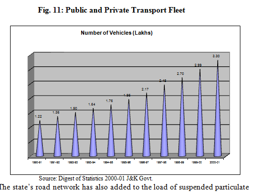
The number of S.S.I. units registered with Directorate of Industries & Commerce increased from 8428 in 1980-81 to 29963 in 1990-91 and at present the number is 42716. Number of registered factories which stood at 574 in 1980-81 has now gone upto 938. Industrial area of Gangyal & Bari Brahmna has brought many changes in the land and water ecology of the area. The total vehicle population which was 1.22 lakh in 1990-91 has now gone upto 3.30 lakh in 2000-01.
Table7: Vehicular Population in J&K</span></p>
|
S. No |
Kind of Vehicle |
31.3.71 |
31.3.75 |
31.3.80 |
31.3.85 |
31.3.90 |
31.3.91 |
31.3.94 |
31.3.95 |
31.3.96 |
31.3.97 |
31.3.98 |
31.3.99 |
31.3.00 |
31.3.01 |
|
1 |
2 |
3 |
4 |
5 |
6 |
7 |
8 |
9 |
10 |
11 |
12 |
13 |
14 |
15 |
16 |
|
1 |
Buses/Mini buss |
813 |
1505 |
2410 |
5047 |
8245 |
9044 |
10403 |
10904 |
11769 |
12623 |
13588 |
14444 |
15583 |
16904 |
|
2. |
Trucks |
1982 |
3506 |
6141 |
10312 |
14531 |
15531 |
18587 |
19352 |
20327 |
22083 |
23931 |
24622 |
25254 |
25845 |
|
3. |
Taxies |
489 |
1221 |
2129 |
2779 |
4447 |
4458 |
4486 |
4496 |
4527 |
4586 |
4633 |
5701 |
6623 |
7985 |
|
4. |
Private cars/ St. wagons |
1828 |
3276 |
4411 |
7641 |
14570 |
15801 |
20256 |
21940 |
24050 |
27377 |
30914 |
36067 |
43030 |
49301 |
|
5. |
Motor cycles/scooters |
1305 |
7244 |
12661 |
23005 |
53666 |
61216 |
88858 |
98689 |
108930 |
121227 |
136496 |
154684 |
171138 |
189456 |
|
6. |
Jeeps |
Incld. In item no. 4 |
1868 |
2289 |
3766 |
5366 |
5824 |
6492 |
6652 |
7191 |
7599 |
8181 |
8615 |
8994 |
10000 |
|
7. |
Auto rickshaws/tampos |
97 |
345 |
1762 |
2378 |
4834 |
5592 |
7436 |
8329 |
10375 |
12602 |
13690 |
15593 |
16647 |
17866 |
|
8. |
Tractors |
17 |
710 |
1287 |
2212 |
3228 |
3458 |
4519 |
4933 |
5295 |
5765 |
6272 |
6953 |
7725 |
8366 |
|
9. |
Trolors |
- |
- |
33 |
172 |
210 |
222 |
410 |
413 |
414 |
414 |
480 |
506 |
523 |
523 |
|
10. |
Others |
61 |
133 |
238 |
686 |
1005 |
1142 |
2139 |
2189 |
2247 |
2335 |
2162 |
2940 |
3567 |
4229 |
|
|
Total |
6592 |
19808 |
33361 |
57998 |
110102 |
122288 |
163586 |
177895 |
195125 |
216611 |
240547 |
270125 |
299104 |
330475 |
Source: Director General Transport, J&K
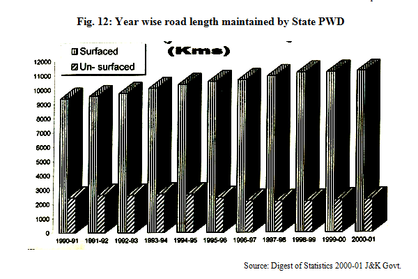
The state’s road network has also added to the load of suspended particulate matter. The total road length is to the tune of 39895 kms., out of which 18659 km is surfaced & 21236 is unsurfaced. The detail of district wise road length is given in the table below:
Table 8: Category wise road length maintained by state PWD excluding <st1:Street w:st="on"><st1:address w:st="on">National Highway</st1:address></st1:Street> as on 31.3.2001 (Provisional)
|
S.No. |
District |
Road length (Kms) |
|||||
|
Black topped |
Metalled |
Shingled |
Fair veathor |
Jeepable |
Total |
||
|
1 |
2 |
3 |
4 |
5 |
6 |
7 |
8 |
|
1. |
Anantnag |
596 |
249 |
378 |
41 |
64 |
1328 |
|
2. |
Pulwama |
455 |
378 |
42 |
3 |
- |
878 |
|
3. |
<st1:City w:st="on">Srinagar</st1:City> |
1002 |
316 |
68 |
19 |
20 |
1425 |
|
4. |
Budgam |
436 |
296 |
377 |
13 |
- |
1122 |
|
5. |
Baramulla |
576 |
568 |
303 |
89 |
17 |
1553 |
|
6. |
Kupwara |
259 |
315 |
137 |
91 |
21 |
823 |
|
7. |
Leh (R) |
183 |
42 |
191 |
709 |
39 |
1164 |
|
8. |
Kargil (R) |
120 |
192 |
88 |
240 |
36 |
676 |
|
9. |
<st1:City w:st="on">Jammu</st1:City> |
1560 |
26 |
36 |
121 |
10 |
1753 |
|
10. |
Udhampur |
381 |
98 |
55 |
216 |
1 |
751 |
|
11. |
Doda |
197 |
212 |
13 |
231 |
4 |
657 |
|
12. |
Kathua |
567 |
62 |
47 |
114 |
2 |
792 |
|
13. |
Rajouri |
166 |
60 |
126 |
166 |
- |
518 |
|
14. |
Poonch |
104 |
8 |
50 |
56 |
2 |
220 |
|
Total |
6602 |
2822 |
1911 |
2109 |
216
|
13660 |
|
Source: Public Works Department.
The brick kilns, coal based SSI units, thermal power stations, cement factories, stone crushers, etc, are also adding to the air pollution. In rural areas also, the air quality is deteriorating due to burning of plastic & agricultural waste, use of agrochemicals in the form of fertilizers & insecticides, use of tractors, rice mills, harvester combines, diesel operated vehicles & tube wells, plying of vehicles on un-mateled kacha roads and installation of various SSI units like stone-crushers.
Water resources
Rivers: Rivers have a special importance in Ladakh as these are the lifelines of the people and nuclear centers of culture and civilization. Here, the rivers are older than the mountains and through ages have kept their own channels with greater force of erosion. This type of drainage is of an antecedent type, in which the main channels of flow were in existence before the present features of the region were impressed on it. The drainage system of Ladakh consists mainly of three great mountain feeders of the Indus, the Indus proper, the Shyok and the Zanskar rivers. The Indus river flows in a north west direction and its Chief tributaries are on the left bank are Hanley, Zanskar, Dras and Astor rivers. The Dras river is formed of the united streams of the Wakha, the Suru, the Dras and the Kuksor rivers. The Shyok receives the Nubra and the Changchenma rivers while the Shigar is formed by the confluence of Basha and Baldu rivers. The Indus originates near lake Mansarover in Tibet and enters south eastern corner of Kashmir. It flows along the deep gorge all along the length of Ladakh and after traversing the mountain ranges of Kishan Ganga Valley in Kashmir, it enters West-Pakistan. The entire catchment area of the Indus in North-West India and Pakistan is 116.50 million sq. km. of which 0.45 million sq. km. lie in the Himalayan mountains. The total length of the Indus from its origin to the sea is 2880 km. of which 114 km lie in India (Murthy, 1981).
Development of water Resources of Ladakh especially Indus river can be used as a source of hydroelectric power, irrigation of farms, fish for markets and access to river transport for trade but Indus region had no major cities or industries, nor a single dam or bridge on the mainstream, the people living along the river course are among the poorest in the world and development even of a small dam or factory could revolutionize the economy of this region.
Jammu region can be categorized into outer plains, outer hills and middle mountains. Outer plains lie between river Ravi on the east and river Chenab in the West. In this part of Jammu, terrain is broken by the tributaries of river Chenab & Ravi. Broad longitudinal valleys form a conspicuous feature of the topography of this region. In this region lies the semi-arid tract of Kandi where water scarcity is the major problem of the people. The Government has sunk a large number of tube wells and wells which not only supply drinking water but also water for irrigation. Traditional village ponds also supplement the water requirements. Two important canals, one from river Tawi and another from river Ravi have been constructed by the Government to provide irrigation facilities in the region.
Outer plains are full of small seasonal streams which carry water only during rainy season and remain dry for most part of the year. Important streams which lie between river Ravi & Chenab are Ujh, Basantar & Tawi.Ujh & Tawi are of perennial nature but water flow varies from season to season. Their catchment areas rise to an elevation of 3936 (for Ujh) & 4263 metres (for Tawi) but do not have perpetual snow. Tawi river flows for about 128 kms before entering into plains near Jammu, wheres Ujh river joins plains near Jasrota after traversing a distance of 30 kms. River Ujh has comparatively steeper bed and carries bigger boulders than river Tawi.
About 32 kms west of river Tawi, river Chenab flows near the town of Akhnoor. Upto this point, river has many rapids and is not fit for navigation. This river originates in Himachal Pradesh and enters in Jammu and Kashmir in district Doda. The river Neeru joins from Bhaderwah at Doda. To the west of river Chenab, another important stream of Munawar Tawi rises from Ratan range behind Rajouri and joins Chenab in the plains.
Outer hills or Shivaliks have a regular and gentle topography. The hills are formed of young tertiary rocks & never reach a height of more than 1200 metres.In this region, numerous small longitudinal valleys called Duns are found. To the north of Dansal Dun, a longitudinal valley runs on the opposite side of Ramkot. It is at Dansal that the river Tawi traverses in a gorge with a steep ascent across the main highway to Kashmir. This region basically forms the catchment area for the tributaries like Ravi, Tawi and Chenab.
Middle Himalayan ranges start from 13 to 16 kms north of Basohli and run along Ramnagar, Reasi and Rajouri. On the north, middle mountains are bounded by two lofty ranges, one being the Pir-Panjal and other range which ends at Kishtwar. Deep ravines have developed in this region due to severe erosion over the centuries. Upper course of river Chenab and its tributaries owe their origin in this region. These rivers are perennial and are fed by the snow that falls on these mountains. Neeru a tributary of river Chenab, flows through Bhaderwah. Neeru starts partly from Kaplash Kund situated at altitude of 4115 m and partly from Chhatrdhar Padri ranges. Bhaderwah valley is a little fertile valley and affords a favourable climate for the cultivation of rice and fruit trees. Other smaller valleys in Bhaderwah are Chirala valley, Jai valley and Neeru valley. There are numerous streams flowing from south east to north west direction and join the river Chenab in 8 drainages called Neeru, Chirala, Jungalwar, Jai Bhalesa, Bunjawa, Guntrer and Padri.
Kishtwar valley is an undulating plain bounded by lofty mountains River Chenab flows through this region. The Dul Husti Hydroelectric Project is under construction over river Chenab at Kishtwar in addition to Salal Hydroelectric Project of Reasi. At Ramban, river chenab flows in a narrow gorge and whole area is full of small beautiful valley of varying dimensions.
The valley of Kashmir is drained by the river Jhelum. In the initial stretch of 48 kms of its course the fall in gradient of river Jhelum is 51 m whereas in the next stretch of 40 kms, gradient is reduced to 17 m. The famous Dal-lake is also connected to this river by a narrow channel. After flowing in a north-westerly direction, river joins Wular lake.
The valley of Kashmir has many tributary valleys, important ones are the Lolab valley, Sind valley and the Lidder valley. Lolab valley is located north of Baramula and is most picturesque of all the valleys. It is 22.4 kms in length and 5 km in width. Numerous hill streams fed by perpetual snow drain this valley and supports luxuriant Biodiversity. Sind valley is named after the river Sind whose uppermost feeders rise below the lofty peaks near Zojila. Many tributaries join from Amarnath, Kalohoi and Panchtarni mountains. From Sonamarg onwards, more tributaries join the river Sind which in its next course flows through narrow channels and gorges before joining river Jhelum. One branch of river Sind, however, flows to the Anchar lake instead. This valley which is 96 kms long is covered by luxuriant forests and supports a rich Biodiversity.
Sind valley is named after the river Sind whose uppermost feeders rise below the lofty peaks near Zojila. Many tributaries join from Amarnath, Kalohoi and Panchtarni mountains. From Sonamarg onwards, more tributaries join the river Sind which in its next course flows through narrow channels and gorges before joining river Jhelum. One branch of river Sind, however, flows to the Anchar lake instead. This valley which is 96 kms long is covered by luxuriant forests and supports a rich Biodiversity.
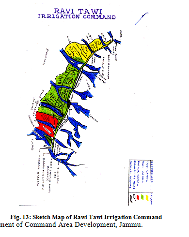
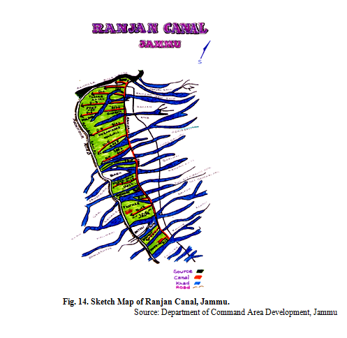
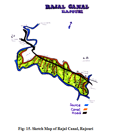
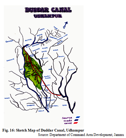
Springs: In Jammu region, spring is known by the term Baoli or Baan whereas in Srinagar a water spring is called as Nag. Located amidst shady trees, Baolies are found everywhere in villages. Many a times, springs are used as places to perform religious ceremonies. They are also decorated with various kinds of sculptures associated with Gods and Goddesses (Lalit Gupta, Sacred Springs of Jammu Shivaliks, March, 2003) Irrigation Canals: In Jammu region, most of land in the Ravi-Tawi Command Area has got good facility of irrigation. The culturable Command Area in this region is 73000 ha with an irrigation potential for 58326 ha against which utilized potential is 32000 ha. Besides 5000 ha more area has been brought under irrigation due to conjuctive use of water which has become available through installation of pump sets. Prominent canals contructed under Command Area Development Project are Duddar Canal (Udhampur), Rajal Canal (Rajouri), Ranjan Canal (Jammu) and Ravi Tawi Irrigation Command which are depicted below :
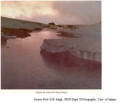
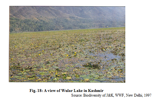
Lakes & Ponds: Many Lakes, Ponds and Wetlands are also source of water in the state. The prominent lakes are Mansar, Saruinsar (Jammu region), Dal, Wullar, Mansbal, Nilnag, Mirgund, Haigam, (Kashmir region), Pangongtso, Tso Morari, Tso Kar, (Ladakh region). The prominent ponds of Jammu include Kunjwani Pond, Pateri Pond, Bawey-Da-Talaa, Dade-Da-Talaa, Badori-da-Talaa, Shayey-da-Talaa, Birpur Pacca Talaa, Buchri Talaa, Madhana Talaa, Purmandal Talaa, Panpedi Pond, Balooni Pond, Salain Talab, Gandharwan Pond, Satura Pond, Mela Pond, Nagbani Pond, Dumel Pond, Suchani Pond, Rajpura Pond, etc. Many ponds which used to exist in the past but now stand vanished are Ban Talaa, Rani-da-Talaa, Patoli Talaa, Rode-di-Chhapri, Tillo Talaa, Satwari Rani Talaa, etc. Prominent wetlands in the state are Shalla Bagh, Hokersar, Shabug (Kashmir) Pargwal, Gharana, Kukrian (Jammu), Chang thang, Noori chan, Chashool, Hanley (Ladakh).
Prominent lakes of J&K are Pangong, Tsomoriri, Mansar, Surinsar, Sheeshnag, Manasbal, Wular lake and Dal lake. The details of important lakes is as under:
Springs: In Jammu region, spring is known by the term Baoli or Baan whereas in Srinagar a water spring is called as Nag. Located amidst shady trees, Baolies are found everywhere in villages. Many a times, springs are used as places to perform religious ceremonies. They are also decorated with various kinds of sculptures associated with Gods and Goddesses (Lalit Gupta, Sacred Springs of Jammu Shivaliks, March, 2003) Irrigation Canals: In Jammu region, most of land in the Ravi-Tawi Command Area has got good facility of irrigation. The culturable Command Area in this region is 73000 ha with an irrigation potential for 58326 ha against which utilized potential is 32000 ha. Besides 5000 ha more area has been brought under irrigation due to conjuctive use of water which has become available through installation of pump sets. Prominent canals contructed under Command Area Development Project are Duddar Canal (Udhampur), Rajal Canal (Rajouri), Ranjan Canal (Jammu) and Ravi Tawi Irrigation Command which are depicted below :
|
Name of the <st1:place w:st="on">Lake |
Location |
Area |
|
<st1:place w:st="on">Wular Lake |
34°-16’ to 34°-26’ N Latitude 74°-32’ to 74°-42’ E Longitude |
65 sq. km. |
|
<st1:place w:st="on">Dal Lake |
32°-54’ Latitude 75°-02’ Longitude |
11 sq. km. |
|
Manasbal |
34°-15’ Latitude 74°-44’ Longitude |
135 ha. |
|
Neelnag |
33°-51’ Latitude 74°-44’ Longitude |
7.5 ha. |
|
Neelsar lake |
33°-32’ Latitude 74°-33’ Longitude |
1.50 ha. |
|
Kounsarnag |
33°-31’ Latitude 74°-50’ Longitude |
137.5 ha. |
|
Chandsar lake |
34°-09’ Latitude 75°-10’ Longitude |
12.5 ha. |
|
Demansar lake |
32°-52’ Latitude 74°-25’ Longitude |
16.25 ha. |
|
Diduf Nag |
33°-52’ Latitude 75°-28’ Longitude |
N.A. |
|
Gaditar lake |
33°-53’ Latitude 74°-28’ Longitude |
N.A. |
|
Gadsar |
34°-25’ Latitude 75°-26’ Longitude |
39.25 ha. |
|
Gangabal lake |
34°-26’ Latitude 74°-58’ Longitude |
150 ja. |
|
Gogisar |
33°-31’ Latitude 74°-28’ Longitude |
N.A. |
|
Gumsar Nag |
33°-41’ Latitude 74°-36’ Longitude |
3.25 ha. |
|
Marsar lake |
34°-9’ Latitude 5°-9’ Longitude |
40 ha. |
|
Sheshnag |
34°-5’ Latitude 75°-33’ Longitude |
81.25 ha. |
|
Sonasarnag lake |
34°-4’ Latitude 75°-31’ Longitude |
1.00 ha |
|
Ratansar lake |
34°-27’ Latitude 74°-22’ Longitude |
N.A. |
|
Tarsar lake |
34°-8’ Latitude 75°-12’ Longitude |
81.25 ha. |
|
Vethnar lake |
34°-3’ Latitude 74°-52’ Longitude |
N.A. |
|
Vishansar lake |
34°-24’ Latitude 75°-9’ Longitude |
37.5 ha. |
|
Zamti nag lake |
34°-5’ Latitude 75°-33’ Longitude |
10.5 ha.
|
|
Kounsar nag |
34°-8’ Latitude 75°-31’ Longitude |
8.15 ha. |
|
Narkura lake |
|
752.5 ha. |
Source: Classified directory of lakes and water bodies J&K, Directorate of Environment & Remote Sensing 1998.
Soils
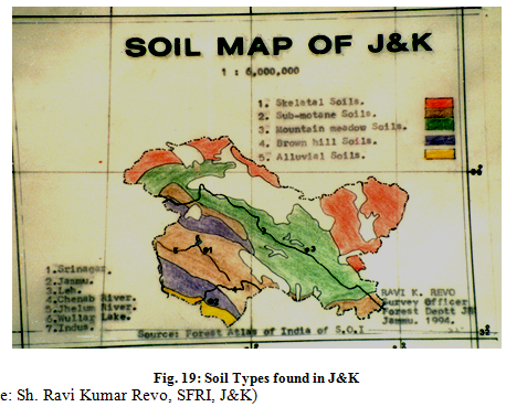
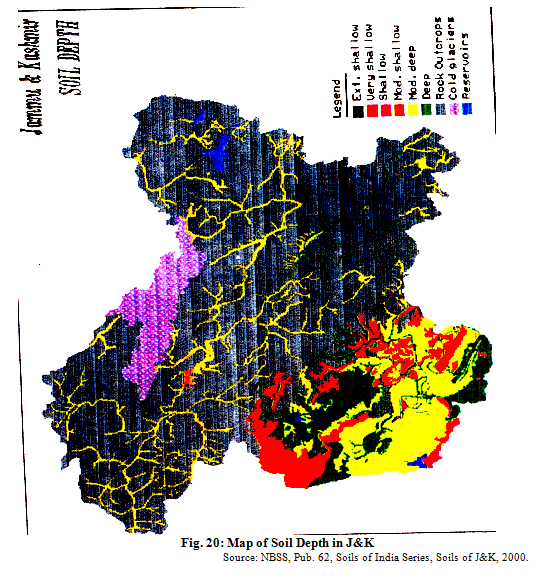
Rich soil diversity exists in the state of Jammu & Kashmir. Kashmir Soils Raza et al (1979) has described various types of soils of Kashmir in the valley basin, highlands and Karewa uplands:
I. Valley soils: These soils abound in organic matter and other plant nutrients. They are quite rich in calcium and magnesium and texture varies from clayey loam to loam. These soils are found in valley basin and the low altitude terraces in the side valleys. II. Highland Soils: Highland soils are mostly silty and clayey and are found on the mountain slopes having forests and interspersed patches of grasslands. III. Karewa Soils: These soils are composed of silt and are poorer in comparison to valley soils. Based on color, they vary from light and red coloured Karewa soils to dark black soils. These soils are economically very important and used for growing fruit trees and saffron cultivation. According to a local classification of soils, following four types of soils are recognised in Kashmir: a) Gurti Soils: Soils which are rich in silt and clay, have high water retaining capacity and can support good growth of crops even in conditions of scanty rainfall , are placed in this category. These soils are subject to frequent flooding by the river Jhelum and silt deposition takes place repeatedly. b) Bahil Soils: Such types of soils are highly fertile and are basically rich loam with varying proportions of silt, clay and sand. These are suitable for paddy cultivation. c) Sekil Soils: These soils have more sand content and have a coarse texture in comparison to Bahil types of soils. Such soils are found in the Sindh Valley and vast tracts under forests also have these types of soils. d) Dazanland Soils: Low valley areas have these types of soils and are of two sub-types one found along the fringes of the swamps (dozanlad type) and other type is characteristic of the Swamps (nambal type).
Locally speaking, there are few more soil types like Surhzamin (vegetable soils), Lemb (tracts served by a spring), Radh (floating garden soil), Tand (Reclaimed mountain soils), Zabalzamin (Excessively irrigated & less fertile soils), Kharzamin (Sailine soils), Shath (sandy soils alongside rivers) and Tads (Stoney and Gravelly soils).Ladakh Soils: The soils of Ladakh are generally sandy to sandy loams with low moisture retaining capacity. These soils are alkaline with pH ranging from 7 to 9. Soils under Kankarpans are generally neutral and are slightly alkaline to just alkaline. Salty encrustations are frequently noticed in highly compact hard soils.
The soils of Jammu are broadly classified as under:
(a) Jammu plain low altitude sub tropical region - recent alluvial. Sub-zone-kandi and unirrigated areas - recent alluvial (Sandy loam)
(b) Intermediate zone-recent alluvial & brown hill soils
(c) Temperate zone-Pod soils.
The soil depth of recent alluvial plains is fairly deep ranges from 8' to 10' and that of the sub-zone kandi unirrigated areas is 0.5'-6' with predominance of stones and pebbles.The soils of Jammu province are sandy loam to clay-loam in texture with medium in NPK status. However, soils of Doda district are high in P&K status. In general 77 percent of the farmers are using only nitrogenous fertizers while 18 % use N&P and 5% use NP & K. The N, P&K is used in the ratio of 32:12:1 in the regionThe soils of the state have been classified according to keys to Soil Taxonomy (1990) in 4 orders, 9 suborders, 15 great groups, 27 subgroups and 66 soil families. The Entisols were observed to be dominant soils covering around 34% of total geographical area followed by Inceptisols (6.4%). Alfisols (0.5%) and Hapludolls (0.2%).
The detail is given in the table below:
Table 9: Area distribution of different soil orders, sub-orders, great groups and sub-groups in
J&K
|
Order Suborder |
Great Group |
Sub-group |
Families |
Areaha % |
|
1 |
2 |
3 |
4 |
5 |
|
Alfisols |
Hapludifs |
Typic Hapludalfs |
Fine-loamy |
36.4 (0.2) |
|
100 (0.5) |
100.5 (0.5) |
80.8 (0.4) |
Fine-silty |
8.0 (Neg.) |
|
Udalfs |
|
Aquic Hapludalfs |
Fine |
36.4 (0.2) |
|
100 (0.5) |
|
19.2 (0.1) |
Fine-silty |
19.2 (0.1) |
|
Entisols |
Cryorthents |
Lithhic Cryorthents |
Fragmental |
666.3 (3.0) |
|
7572.6 (34.1) |
4842 (21.8) |
3521.7 (15.9) |
Sandy-skeletal |
747.8 (3.4) |
|
Orthents |
|
|
<st1:City w:st="on"><st1:place w:st="on">Sandy</st1:City> skeletal caleareous |
1159.4(5.2) |
|
6846.2(30.8) |
|
|
Loamy |
1994.4(0.9) |
|
|
|
|
Loamy, calcareous |
748.9(3.4) |
|
|
|
Typic Cryorthents |
<st1:City w:st="on"><st1:place w:st="on">Sandy</st1:City> skeletal |
599.2(2.7) |
|
|
|
1320.2 (5.9) |
<st1:City w:st="on"><st1:place w:st="on">Sandy</st1:City> skeletal calcareous |
92.0(0.4) |
|
|
|
|
Loamy skeletal |
359.2(1.6) |
|
|
|
|
Loamy skeletal calcareous |
31.2(0.1) |
|
|
|
|
Coarse loamy calcareous |
52.0(0.2) |
|
|
|
|
Fine loamy |
186.6(0.8) |
|
|
Udorthents |
Lithic Udorthents |
Loamy skeletal |
236.3(1.1) |
|
|
1910 (8.6) |
596.6(2.7) |
Loamy |
360.3(1.6) |
|
|
|
Typic Udorthents |
<st1:City w:st="on"><st1:place w:st="on">Sandy</st1:City> skeletal |
16.0(0.1) |
|
|
|
1293.6(5.8) |
Loamy skeletal |
272.9(1.2) |
|
|
|
|
Clayey skeletal |
10.1(0.1) |
|
|
|
|
Coarse loamy |
669.9(3.0) |
|
|
|
|
Fine loamy |
393.8(0.9) |
|
|
|
|
Fine loamy calcareous |
31.8(0.1) |
|
|
|
Mollic Udorthents |
Fine loamy |
19.7(0.1) |
|
|
|
19.7 (0.1) |
|
|
|
|
Ustorthents |
Typic Ustorthents |
Loamy skeletal |
63.7(0.3) |
|
|
94.3(0.4) |
94.3 (0.4) |
Coarse loamy |
29.7(0.3) |
|
|
|
|
Fine loamy |
0.9(Neg) |
|
Fluvents |
Cryofluvents |
Typic cryofluvents |
Coarse loamy |
120.6(0.5) |
|
269.5(1.2) |
243.0(1.1) |
214.4(1.0) |
Coarse loamy calcareous |
93.7(0.4) |
|
|
|
Mollic cryofluvents |
Coarse loamy calcareious |
28.6(0.1) |
|
|
Udifluvents |
Type udifluvents |
Fine loamy |
11.4(0.1) |
|
|
11.4(0.1) |
11.4(0.1) |
|
|
|
|
Ustifluvents |
Typic ustifluvents |
Coarse loamy |
7.0(Neg) |
|
|
15.0(0.1) |
15.0(0.1) |
Fine silty |
8.0(Neg) |
|
Aquents |
Fluvaquents |
Typic Fluvaquents |
Coarse loamy calcareous |
15.5(0.1) |
|
15.5(0.1) |
15.5(0.1) |
15.5(0.1) |
|
|
|
Psamments |
Cryopsamments |
Typic cryopsamments |
<st1:City w:st="on"><st1:place w:st="on">Sandy</st1:City> |
144.6(0.6) |
|
441.4(2.0) |
441.4(2.0) |
441.4(2.0) |
<st1:City w:st="on"><st1:place w:st="on">Sandy</st1:City> calcareious |
296.7(1.3) |
|
Inceptisols |
Cryochrepts |
Typic cryochrepts |
Coarse loamy |
34.3(0.2) |
|
1427.2(6.4) |
145.7(0.7) |
91.3(0.4) |
Coarse loamy calcareious |
7.8(Neg) |
|
Ochrepts |
|
|
Fine loamy |
3.2(Neg) |
|
1360.1(6.1) |
|
|
Fine loamy calcareous |
45.9(0.2) |
|
|
|
Fluventic cryochrepts |
Coarse loamy |
32.8(0.2) |
|
|
|
54.4(0.3) |
Coarse loamy calcareous |
21.6(0.3) |
|
|
Dystrochrepts |
Typic dystrochrepts |
Fine loamy |
116.9(0.5) |
|
|
134.2(0.6) |
134.2(0.60) |
Fine |
17.3(0.1) |
|
|
Eutrochrepts |
Dystric euttochrepts |
Fine loamy |
587.2(2.6) |
|
|
922.3(4.1) |
865.4(3.9) |
Fine silty |
45.3(0.2) |
|
|
|
|
Fine |
31.2(0.1) |
|
|
|
Aquic dystric |
Fine loamy |
2.8(Neg) |
|
|
|
Eutrochrepts |
|
|
|
|
|
2.8(Neg) |
|
|
|
|
|
Fluventic eutrochrepts |
Coarse loamy calcareous |
18.3(0.1) |
|
|
|
21.0(0.1) |
Coarse loamy |
2.5(Neg) |
|
|
|
Typic Eutrochrepts |
Coarse loamy |
13.3(0.1) |
|
|
|
29.8(0.1) |
Fine silty calcareous |
6.3(Neg.) |
|
|
|
|
Fine calcareious |
10.2(0.1) |
|
|
|
Vertic eutrochrepts |
Fine |
2.9(Neg) |
|
|
|
2.9(Neg) |
|
|
|
|
Ustochrepts |
Udic ustochrepts |
Coarse loamy |
9.5(Neg) |
|
|
157.8(0.7) |
94.4(0.4) |
Fine loamy |
84.9(0.4) |
|
|
|
Fluventic ustochrepts |
Coarse loamy |
43.5(0.2) |
|
|
|
63.4(0.3) |
Coarse loamy calcareous |
19.3(0.1) |
|
|
|
|
Fine loamy calcareous |
1.6(Neg.) |
|
Aquepts |
Haplaquents |
Typic Haplaquents |
Fine loamy |
10.3(Neg) |
|
67.2(0.3) |
67.2(0.3) |
52.5(0.2) |
Fine loamy calcareous |
22.2(0.1) |
|
|
|
|
Fine silty calcareious |
20.1(0.1) |
|
|
|
Aeric Haplaquepts |
Fine loamy calcareious |
12.4(0.1) |
|
|
|
14.6(0.1) |
Fine calcareous |
2.2(Neg) |
|
Mollisols |
Hapludolls |
Typic Hapludolls |
Fine loamy |
47.7(0.2) |
|
47.7(0.2) |
47.7(0.2) |
47.7(0.2) |
|
|
|
Udolls |
|
|
|
|
|
47.7(0.2) |
|
|
|
|
Source: NBSS, Publ. 62, Soils of India Series, Soils of J&K for Optimizing Land use, 2000
</p
Socio-economic Profile
For the socio-economic upliftment of any society, state or country, socio-economic aspects need to be taken into consideration for drawing any future plan or a policy. It must reflect the strength and weaknesses of socio-economic data which include demographic profile, key ethnic groups, main occupations, agriculture & allied activity scenario, energy scenario and state’s economy.
Demographic & Social Parameters
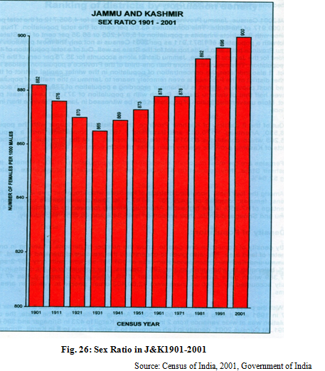
As per 2001 census report of J&K, state’s population stands as 10,069,917 with males being 5,300,574 and females being 4,769,343. As per the previous census figure of 1981, the annual increase in population was 3.41%. The state has ranked 19th in population size among states of India but it ranks 33rd in literacy and 26th in sex-ratio as compared to India.
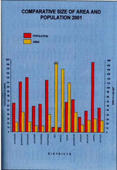
District wise census data reveals that, Jammu district has largest population of 1,571,911 and Poonch district has the smallest population of 371,561 individuals. Areawise, Leh district is the largest and Pulwama district is the smallest. Srinagar district has the maximum density of 556 persons per sq. km. whereas Leh district has more sparse density of 3 individuals per sq. km.
Table 10: Demographic parameters of J&K vs. India.
|
Parameters |
<st1:place w:st="on">India |
J&K |
|
Total Population |
1,027,015,247 |
10,069,917 |
|
Male Population |
531,277,078 |
5,300,574 |
|
Female Population |
495,738,169 |
4,769,343 |
|
Sex Ratio (females/1000 males) |
933 |
900 |
|
Total Literacy Rate (%) |
65.38 |
54.46 |
|
Male Literacy Rate (%) |
75.85 |
65.75 |
|
Female Literacy Rate (%) |
54.16 |
41.82 |
|
Density per sq. km. |
324 |
99 |
|
Rank in 2001 |
District |
Population in 2001 |
Population in 1991 |
Rank in 1991 |
|
1. |
<st1:City w:st="on">Jammu</st1:City> |
1,571,911 |
1,224,300 |
1 |
|
2. |
<st1:City w:st="on">Srinagar</st1:City> |
1,238,530 |
942,200 |
2 |
|
3. |
Anantnag |
1,170,013 |
881,700 |
4 |
|
4. |
Baramulla |
1,166,722 |
889,400 |
3 |
|
5. |
Udhampur |
738,965 |
582,100 |
5 |
|
6. |
Doda |
690,474 |
544,700 |
6 |
|
7. |
Kupwara |
640,013 |
461,800 |
9 |
|
8. |
Pulwama |
632,295 |
507,900 |
7 |
|
9. |
Badgam |
593,768 |
469,400 |
8 |
|
10. |
Kathua |
544,206 |
450,100 |
10 |
|
11. |
Rajouri |
478,595 |
382,300 |
11 |
|
12. |
Poonch |
371,561 |
290,100 |
12 |
|
13. |
Leh |
117,637 |
90,200 |
13 |
|
14 |
Kargil |
115,227 |
87,700 |
14 |
</
Census data reveals that in Jammu province, literacy rate among females varies from 28.35%, in Doda district to 68.75% in Jammu district with an average literacy of females for the province as 45.06%. In comparison, in Kashmir province, the female literacy rate (including Ladakh) is highest in Leh with 50.03% followed by Srinagar with 48.11% and for other districts it varies from 26.60% in Badgam to 40.96% in Kargil district, with an average of 36.30% literacy among females in Kashmir province. Among males, Badgam with 51.23% male literacy holds the lowest rank while Jammu with 84.92% is at the top followed by Kathua (75.73%) and Kargil (73.58%). Other six district with more than 60% male literates are Leh (71.98%), Rajouri (69.64%), Srinagar (68.99%), Poonch (65.41%), Udhampur (66.43%) and Doda (63.56%).
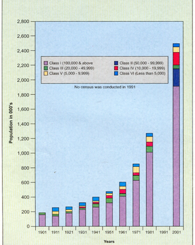
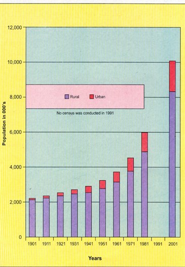
Analysis of the census figures of 2001 further reveals that out of total population (10,069,917), rural population comprises of 7,564,608 individuals and urban population of 2,505,309 persons.
|
Year |
Total |
Rural |
Urban |
|
|
1901 |
2,139,632 |
1,980,614 |
158,748 |
|
|
1911 |
2,292,535 |
2,024,017 |
268,518 |
|
|
1921 |
2,424,359 |
2,156,605 |
267,754 |
|
|
1931 |
2,670,208 |
2,352,403 |
317,805 |
|
|
1941 |
2,946,728 |
2,560,163 |
386,565 |
|
|
1951 |
3,253,852 |
2,796,639 |
457,213 |
|
|
1961 |
3,560,976 |
2,967,661 |
593,315 |
|
|
1971 |
4,614,632 |
3,758,411 |
858,221 |
|
|
1981 |
5,987,389 |
4,726,986 |
1,260,403 |
|
|
1991 |
--- |
--- |
--- |
|
|
2001 |
10,069,917 |
7,564,608 |
2,505,309 |
|
|
Note: No cencus was conducted in 1991 |
||||
Source: Census of India, 2001, Government of India
The child population in 0-6 age group constitute 14.21% of the total population in the state. Poonch district revealed the highest child population with 17.67% to the total population followed by Kupwara district with 17.25%. Leh district showed the lowest child population of 6.16% followed by Srinagar district as 10.13% and Pulwama with 12.09%. This indicates more urbanisation and literacy less children. The national average of child population is 15.37%. The state of J&K ranks 16th in child population in comparison to other states and Union Territories. 82.01% of the child population lives in rural areas whereas 17.99% lives in urban areas, though the urban population to the total population of the state is 24.88% and rural population is 75.12%.
Key Ethnic Groups
Different ethnic groups have different life styles and their intimate relationship with different Biodiversity Components is also distinct. Some of the well known ethnic groups present in Jammu, Kashmir and Ladakh are enumerated below:
Ethnic groups of Jammu region
I. Dogras: The inhabitants of Jammu region who speak Dogri Language and have typical Dogra religious and cultural traditions are called Dogras. Present population of Dogras is more than 30 lakh within J&K state. Main occupation is agriculture, sheep and animal husbandry. This is a distinctive ethnic group of Jammu and their major concentration arose around two holy lakes of Mansar & Suruinsar. They belong to the Aryan race and speak Dogri language. A substantial section of Dogras embraced Islam during 16th & 17th centuries and at the time of partition most of the Dogra Muslims migrated to Pakistan. Dogras are short statured and have high shoulders. There is a tradition of worshipping trees like Peepal, Tulsi, Bil-pattri and animals like cows, serpents, etc.
II. Chibhalis: They belong to the Dogra racial group and occupy the southern slopes of Shivaliks between Chenab and Jhelum rivers previously called ‘chibhal’ by the Muslim rulers of the medieval times and one of the Rajput clan called ‘Chib’ inhabited that region. They resemble Dogras but are mainly the followers of Islam. Presently they are concentrated in Akhnoor, Mendhar, Haveli, Rajouri & Nowshera. III. Gujjars: Gujjars are cattle rearing pastoral nomads who migrated from Rajasthan, Gujarat & Kathiawad at the time of occurrence of droughts in those places in the 6th & 7th century. The section of migratory tribes called Gujjars moved to the Punjab and then to various areas of J&K like Kanghan, Swat, Hazara, Gilgit and Kashmir valley. The major concentration of Gujjars lies in Kathua, Jammu, Rajouri, Poonch, Uri, Ganderbal & Kandi areas. They move with their cattle herds on a seasonal basis but many of them have now startd settling on permanent basis. They have good indigenous knowledge pertaining to different elements of Biodiversity. IV. Bakkerwals: Like Gujjars, these people have also migrated from the Rajasthan & Gijarat in the distant past. They move with herds of horses & flocks of goat & sheep. They oscillate between higher pastures & low lying plains and are intimately associated with different elements of Biodiversity. V. Gaddis: This is a community of shepherds who possess large flocks and sheep and herds of goats. They migrate with their flocks to different altitudes in search of grass and water. Their life style is closely linked with biodiversity and as a result of age-old tradition of nomadism, they have a good treasure of Indigenous knowledge pertaining to various aspects of Biodiversity. They are essentially Rajputs and are the followers of Hinduism. Various villages of Bhaderwah (Kansar, Dhamunda, Bharai), Batote, Ramnagar & Basohli Tehsils have their major concentrations.
Ethnic Groups of Kashmir Region
I. Kashmiris: Major community of the Kashmir is Kashmiri - whose concentration lies in Kashmir, Kishtwar, Bhaderwah & Ramban but due to present turmoil many Kashmiri Pandits have migrated outside the valley and are presently confined to places like Udhampur & Jammu. Kashmiris are broad shouldered and medium to tall statured. They wear short pyjamas, a long loose large sleeved gown called ‘Phiran’ and a skull cap. Kashmiris speak kashmiri language and have distinct culture of their own. II. Hanjis: This community forms a district ethnic group in the Kashmir valley. They are confined to water bodies like Dal, Wular, Anchar lakes and Jhelum river. They are sturdy and hard working people who are closely associated with Biodiversity and on the basis of occupation, they are categorised as vegetable growers (Demb-Hanzi), Waternut gatherers (Gari-Hanzi), Fishermen (Gad-Hanzi), Wood dealers (Mata-Hanzi), Boat wales (Dunga Hanzi), Wood collectors (Haka Hanzi), Bahatch boat walas (Bahatchi-Hanzi), Shikarawalas (Shikara Hanzi) & House boat walas (Houseboat Hanzi).
Ethnic Groups of Ladakh Region
Ladakh the land of high passes, covers an area of approximately 98000 sq. km. with a sparse populationof about 135000. All habitations are located near water courses along the valleys. As the terrain is high and barren, people use animals for traversing long distances and carrying goods. They use animals like Yak, Pony, Broad Backed Hunia Sheep and two Humped Bactrian Camel. Ethnic groups of this region are: I. Mons: They belong to Aryan race and are professional musicians who move from place to place playing their musical instruments.
II. Dards: They are confined mainly to Drass and the Indus Valley. Dards living in and around Drass are Muslims. Those living in Indus valley below Khalsi display a distinct identity preserving their original Buddhhist religion as well as their cultural identity.
III. Tibetans: Eastern and central Ladakh is dominated by this ethnic group. Two groups of Tibetans can be identified, one living at Choglamsar and the nomadic changpas with their herds of Pashmina goats in the eastern plains.
IV. Baltis: They are mainly found in Western Ladakh in the Kargil region but some are also found in Nubra Valley and near Leh town. They are believed to be descendents of the Sakas, a Central Asian race. Presently they have got a schedule tribe status.
V. Brokpas: Brokpas are believed to be the survivors of the pure Aryan race inhabiting the lower Indus Valley from Dah of the Leh District to Baltic of the Kargil district. Villages of Dah-Bema, Hano, Darchik and Garkon are inhabited by 1920 Buddhist Brokpas (Census of India; 1991). The source of the economy of the Borkpa is agriculture, horticulture and animal husbandry. They rear sheep, goats, Dzos, bulls and horses but do not rear cattle because of religious taboo. Poultry farming is also a taboo. Barley, wheat or grim and Cha are main crops.Drew (1875) described Brokpas as casteless
society unlike other Dard communities but have caste like divisions of priests, cultivators and artisans. The artisans include – Gara (Black smiths) and Shinkan (Carpenters). There are no classes of Mon (Musicians), anybody can be a musician, marriages are not permissible between cultivators and garas.
VI. Amchis: Local practioners of health care in Ladakh are called Amchis and the system is referred as Amchis system of Medicine (Swarpa) which is an offshoot of Tibean System of Medicine. This system traces its origin to Ayurvedic System of India and was brought to Tibet in 7th Century A.D. Amchis practise this system through treatment by herbs, treatment by minerals, treatment by animal organs, treatment by spring and mineral waters, treatment by vein puncturing and treatment by mysticism and spiritual powers. The Amchi System recognises the number of categories of diseases and uses about 376 different formulations.
VII. Purigpas: The bulk of Kargil population consists of Purigpas, as the original inhabitants of Purig, the original name of Kargil. Purigs too claim themselves as Baltis but Baths refer them as Purigpa. They profess Islam and their dialect is a mixture of ladakhi and Balti.
VIII. Argons: These are the descendants of immigrants from Kashmir Valley and Central Asia. Most of them were traders but they were also accompanied by men of religion. Many of Kashmiris who settled in Leh married Ladakhi women and left progeny of Argons. They profess Suni faith and are found in both Leh and Kargil districts. Apart from these distinct ethnic groups. 13 recognised scheduled caste communities are Barwals, Basith, Batwals, Chamars (Ramdasia), Chura (Sweepers), Dhyars, Dooms (Mahasha), Gardi Jolaha, Megh (Kabirpanthi), Ratal, Sanyaras, Watals which consists 4.973 lacs population amounting to 8.3% of the total population.
The ‘Meghs’ constitute the dominant scheduled caste community in the Jammu Division as it represents 53 % of the total scheduled caste population.
The ‘Chamars’ who are associated with the traditional occupation of cleaning dyeing, tanning of cattle skins & hides making of leather goods and foot-wears stand 2nd major scheduled caste group after the Meghs. There are as many as 12 Schedule Tribe communities recognized by the state are as Balti, Beda, Bot, Brokpa, Changpa, Garra, Mon, Purigpa, Gujjar, Bakkerwal, Gaddi and Sippi amounting to 8.804 lac which is 11.4% of the total population.
Table 13: Scheduled Castes & Scheduled Tribes of J&K
|
S.No. |
Scheduled Castes |
Population |
Scheduled Tribes |
|
1 |
Barwala |
|
Balti |
|
2 |
Basith |
|
Beda |
|
3 |
Batwal |
|
Bot, Boto |
|
4 |
Chamar |
|
Brokpa, Drokpa, Dard, Shin |
|
5 |
Chura |
|
Changpa |
|
6 |
Dhyar |
|
Garra |
|
7 |
Doom or Mahasha |
|
Mon |
|
8 |
Gardi |
|
Purigpa |
|
9 |
Jolaha |
|
Gujjar |
|
10 |
Megh or Kabirpanthi |
|
Bakkerwal |
|
11 |
Ratal |
|
Gaddi |
|
12 |
Saryara |
|
Sippi |
|
13 |
Watal |
|
|
|
|
TOTAL |
4.973 lac i.e. 8.3 % |
<![if !supportLists]> <![endif]>lac i.e. 11.4 % |
Source: Tribal Welfare and Development, Directorate of Social Welfare J&K 2002-03.
Based on the percentage population of these communities Reservations for Scheduled Caste and Scheduled Tribes and Socially & Educationally Backward Classes in Professional Institutions have been fixed Vide SRO-126 of 1994, dated: 28th June as follows:
1. Scheduled Caste = 8 %
2. Scheduled Tribes
a) Gujjars & Bakerwals = 6%
b) Residents of District Leh = 2%
c) Residents of District Kargil = 2%
d) Other than a, b & c = 1%
3. Socially & Educationally Backward classes (othe than SC & ST)
a) Weak and underprivielged classes (Social Castes) = 2%
b) Residents of Area adjoining Actual Line of Control = 3% c) Residents of Backward area = 20%
Table 14: District wise population of the Scheduled Tribe is given as under:
|
S.No. |
District |
Total Pop. 1991 |
ST Pop. 1987 |
Ested. ST 1991 |
%age of ST Population |
|
|
Kashmir Division |
|
|
|
|
|
1. |
<st1:City w:st="on"><st1:place w:st="on">Srinagar</st1:City> |
913.00 |
43.44 |
48.47 |
5.31 |
|
2. |
Budgam |
473.00 |
9.97 |
11.12 |
2.35 |
|
3. |
Anantnag |
847.00 |
50.17 |
56.01 |
6.61 |
|
4. |
Pulwama |
521.00 |
18.16 |
20.25 |
3.89 |
|
5. |
Baramulla |
864.00 |
62.03 |
69.23 |
8.01 |
|
6. |
Kupwara |
424.00 |
46.55 |
51.93 |
12.25 |
|
|
Sub-Total |
4042.00 |
230.32 |
257.01 |
6.36 |
|
|
Ladakh Division |
|
|
|
|
|
7. |
Leh |
88.00 |
74.62 |
83.40 |
94.77 |
|
8. |
Kargil |
85.00 |
77.43 |
85.00 |
100.00 |
|
|
Sub-Total |
173.00 |
152.05 |
168.40 |
95.30 |
|
|
<st1:City w:st="on"><st1:place w:st="on">Jammu</st1:City> Division |
|
|
|
|
|
9. |
<st1:City w:st="on"><st1:place w:st="on">Jammu</st1:City> |
1216.00 |
31.15 |
34.74 |
5.86 |
|
10. |
Kathua |
476.00 |
20.92 |
23.35 |
4.90 |
|
11. |
Udhampur |
585.00 |
76.10 |
84.88 |
14.51 |
|
12. |
Doda |
548.00 |
70.51 |
78.67 |
14.51 |
|
13. |
Poonch |
289.00 |
104.24 |
116.34 |
40.26 |
|
14. |
Rajouri |
390.00 |
104.96 |
117.01 |
30.00 |
|
|
Sub-Total |
3504.00 |
407.89 |
454.99 |
112.98 |
|
Grand Total |
7719.00 |
790.25 |
880.40 |
11.40 |
|
Source: Tribal Welfare and Development, Directorate of Social Welfare J&K 2002-03.
Agriculture
Agriculture and allied activities constitute the most important sector of state’s economy as it provides livelihood support directly or indirectly to about 80% of state’s population and it contributes 33.41% of the Net State Domestic Product. Out of total geographical area of 222,236 sq. km., total agricultural land in the state is 241,600 ha. The net sown area under various crops like maize, wheat, paddy, barley, pulses, oil seeds, vegetables etc. is 734,000 ha. The total irrigated area is 309,000 ha.
The food-grain production in the state has increased from 4.53 lakh metric tonnes in 1950-51 to 15.44 lakh tonnes in 1994-95. Though there has been substantial increase in the food production, yet the state is not self-sufficient and a large quantity of food items are imported from other states of India. Ever increasing demand and complex agricultural problems of the temperate and cold arid tracts like Paddar, Zanskar, Changthang etc. have forced the Government to initiate various schemes and programmes to increase productivity through a mix of modern inputs like introduction of high yielding varieties, application of fertilisers, use of agrochemicals, high tech machinery and use of improved agricultural implements.
The livestock wealth of the state has exceeded 90 lakh as compared to 40 lakh in 1956. The state has traditionally been deficit in the production of mutton, poultry and milk and the reason attributed to this was low productivity of local breeds. So, livestock breeding programme was initiated and implemented and is still in progress. This sector is presently contributing about 13% of the state’s GDP. Most of the poverty alleviation programmes, launched in the state, are livestock improvement based. Upgradation of local livestock through cross-breeding with high yielding exotic breeds has brought about discernible change in the production of animal products like mutton, eggs, milk, chicken etc. The per capita availability of milk in J&K is about 330 ml. against an average of 220 ml. at the national level and 285 ml. recommended by ICMR and WHO.
Apiculture is another allied activity in the state which has created good employment opportunities for the rural youth and also raised the economic status of the villagers by supplementing their income from this sector. Apiculture was on a very good pedestal of growth till 1986 when unfortunately there was an epidemic of sac brood disease caused by Thai Sac Brood Virus (TSBV) and this almost wiped out the industry in the state. Subsequent introduction of exotic honey bee, Apis mellifera however saved the situation and industry showed the signs of recovery, but the disease has wiped out almost entire stocks of indigenous colonies of local honey bee called Apis cerana Indica. This indigenous strain of honey bee is well adapted to the geographical, climatic and floral conditions of the state. Its capacity to exploit flora at the higher altitudes and low temperature conditions is unique and unparallel (D.P. Abrol & A.A. Bhat, 1990). Local beekeepers have welcomed the introduction of exotic Apis mellifera to keep their profession alive and also because this species has high prolificity, gentle temper, less swarming and absence of any serious disease at present.It has definitely proved to be a serious blow to the native strains.
Another allied sector is sericulture. J&K is the only state which is producing much valued bivoltine type of silkworm cocoons. The state at present ranks fifth in the cocoon production in the country and is producing 900 metric tonnes cocoons annually. About 3100 ha. of land is under the cultivation of various kinds of mulberry trees. Mushroom cultivation is also on the rise in the recent years. Various edible mushrooms presently under cultivation in the state are Agaricus bisporus (Khumb), Pleurotus (Dhingri) etc.
The valley of Kashmir is also famous for its saffron cultivation on the Karewan lands of Pampore. J&K state is the only producer of saffron (Crocus sativus) in South-Asia. Saffron is also grown in some parts of Kishtwar in Jammu province. SKUAST has recently embarked upon an improvement plan for the saffron to boost its cultivation and yield per hectare. Horticulture is another important sector which is age-old in Kashmir. The agro-climatic conditions of the state are well suited for the cultivation of diverse types of fruits. Sub-tropical Jammu belt is suited for the cultivation of fruits like citrus, lemon, galgal, oranges, custard apple, loquat, mango, cherry, banana, papaya, plum guava, jujube, karounda, myrobalans, Indian gooseberry, mulberry etc. and the temperate climate of Bhaderwah and Kashmir is favourable for the cultivation of apples, almonds, cherries, pears, date plum, persimmon (Amlook), apricots, walnuts, Spanish chest-nut (Castanea sativa) etc. Ladakh is known for its high grade apricot cultivation in Kargil and Leh districts.
State government has made phenomenal progress in the field of horticulture. In the year 1953-54, the area under fruit cultivation was merely 12400 hectares and production was about 1600 metric tonnes but present area under different fruit varieties is 2.17 lakh hectares and the annual fruit production is to the tune of 11.5 lakh metric tonnes. The state has 60% share in the apple production of the country. More than 8 lakh tonne fruit is exported annually. More than 5 lakh families are currently involved directly or indirectly with horticulture and according to an estimate around 20-25 lakh people are benefitted by the fruit industry of the state (Anon, 1997).
Table 15: THE DISTRICT WISE PRODUCTION OF MAIN FRUITS IN JAMMU & KASHMIR FOR THE YEAR 1999-000.
Department of Horticulture (Production in Metric Tonnes)
|
S. No. |
Kind of Fruit |
<st1:City w:st="on">Srinagar</st1:City> |
Budgam |
Baramulla |
Kupwara |
Anantnag |
Pulwama |
Total |
Leh |
Kargil |
Total |
<st1:City w:st="on">Jammu</st1:City> |
Kathua |
Poonch |
Rajouri |
Doda |
Udhampur |
Total |
Total |
|
FRESH FRUITS |
|
|
|
|
|
|
|
|
|
|
|
|
|
|
|
|
|
||
|
1. |
Apple |
25506 |
39943 |
522091 |
69219 |
158397 |
100707 |
915863 |
3238 |
294 |
3532 |
0 |
1100 |
3815 |
288 |
2251 |
2173 |
9627 |
929022 |
|
2. |
Pear |
2461 |
3592 |
2051 |
3304 |
2732 |
2345 |
16485 |
6 |
4 |
10 |
0 |
2500 |
6750 |
1050 |
1144 |
1302 |
12746 |
29241 |
|
3. |
Apricot |
268 |
213 |
1056 |
45 |
233 |
250 |
2065 |
2541 |
1153 |
3694 |
0 |
40 |
30 |
55 |
561 |
159 |
845 |
6604 |
|
4. |
Peach |
95 |
20 |
107 |
51 |
57 |
9 |
339 |
6 |
3 |
9 |
28 |
350 |
415 |
88 |
29 |
181 |
1091 |
1439 |
|
5. |
<st1:place w:st="on">Plum |
1028 |
482 |
0 |
62 |
209 |
198 |
1979 |
0 |
0 |
0 |
0 |
65 |
1556 |
120 |
32 |
104 |
1877 |
3856 |
|
6. |
Cherry |
3170 |
152 |
481 |
368 |
419 |
714 |
5304 |
0 |
9 |
9 |
0 |
0 |
0 |
0 |
2 |
1 |
3 |
5316 |
|
7. |
Mango |
0 |
0 |
0 |
0 |
0 |
0 |
0 |
0 |
0 |
0 |
5582 |
3140 |
0 |
908 |
0 |
921 |
10551 |
10551 |
|
8. |
Ber |
0 |
0 |
0 |
0 |
0 |
0 |
0 |
0 |
0 |
0 |
8010 |
21 |
0 |
600 |
0 |
341 |
8972 |
8972 |
|
9. |
Grapes |
1234 |
5 |
22 |
0 |
0 |
0 |
1261 |
8 |
3 |
11 |
178 |
5 |
1 |
0 |
0 |
19 |
203 |
1475 |
|
10. |
Citrus |
0 |
0 |
0 |
0 |
0 |
0 |
0 |
0 |
0 |
0 |
3843 |
5283 |
153 |
1240 |
142 |
2635 |
13296 |
13296 |
|
11. |
Olive |
0 |
0 |
0 |
0 |
0 |
0 |
0 |
0 |
0 |
0 |
0 |
0 |
0 |
0 |
1 |
1 |
2 |
2 |
|
12. |
Other fresh |
1001 |
62 |
1354 |
524 |
47 |
0 |
2988 |
0 |
0 |
0 |
3916 |
678 |
306 |
1042 |
190 |
2112 |
8244 |
11232 |
|
Total Fresh |
34763 |
44469 |
527162 |
73573 |
162094 |
104223 |
946284 |
5799 |
1466 |
7265 |
21557 |
13182 |
13026 |
5391 |
4352 |
9949 |
67457 |
1021006 |
|
|
DRY FRUITS |
|
|
|
|
|
|
|
|
|
|
|
|
|
|
|
|
|
||
|
1. |
Walnut |
1994 |
6071 |
7479 |
5473 |
22869 |
13722 |
57608 |
101 |
10 |
111 |
0 |
4000 |
5730 |
900 |
4061 |
2496 |
17187 |
74906 |
|
2. |
Almond |
141 |
1909 |
9 |
0 |
124 |
7480 |
9663 |
1 |
0 |
1 |
0 |
1 |
0 |
1 |
2 |
4 |
8 |
9672 |
|
3. |
Other dry |
144 |
0 |
0 |
0 |
0 |
0 |
144 |
0 |
0 |
0 |
0 |
0 |
2 |
41 |
0 |
2 |
45 |
189 |
|
Total Dry |
2279 |
7980 |
7488 |
5473 |
22993 |
21202 |
67415 |
102 |
10 |
112 |
0 |
4001 |
5732 |
942 |
4063 |
2502 |
17240 |
84767 |
|
|
Grand Total |
37042 |
52449 |
534650 |
79046 |
185087 |
125425 |
1013699 |
5901 |
1476 |
7377 |
21557 |
17183 |
18758 |
6333 |
8415 |
12451 |
84697 |
1105773 |
|
Source: Directora of Horticulture, J&K
Fisheries is another thrust area for boosting state’s economy. This sector has lot of potential in the state as water resources are more than 400 sq. km. in extent in the form of rivers, lakes, streams, ponds etc. There are more than 600 fishing license holders in the state. Total fish production which was 4277 metric tonnes in 1965-66, 16000 metric tonnes in 1995-96 has now gone upto 19010 metric tonnes in 1999-2000 of which Kashmir region has contributed more than 80% of the total catch (60% coming just from Wular lake alone, 15% from river Jhelum and 5% from other valley lakes) and the remaining 20% has been contributed by Jammu region.
Strengths of the agriculture and allied sectors are enumerated below Indigenous germplasm of various food grains, fruits, vegetables, spices, medicinal and aromatic plants, walnuts, mushrooms etc. is available in the state. Ambri apple, cherries, almonds, walnuts, saffron, kala zeera, bivoltine silk and pashmina are unique to the state of J&K. • Productivity level of maize in Jammu division is much higher than the national level. Record level of productivity, exceeding 100 quintals per hectare stand achieved in Rajouri district. • Valley has strong irrigation network. About 50% of the net sown area has assured irrigation facility. • Due to high level of light intensity and mineral rich soil, superior quality fruits and vegetables are available in Ladakh.
• Saffron of Pampore and basmati of R.S. Pura has unique aromatic properties in whole of the state and fetch higher price in the market.
• Edible mushrooms like guchhi (morels), local pomegranate (darim), beans (rajmah), pashmina wool are of superior quality.
Weaknesses have also been encountered regarding this sector, and they are
• In proportion to vast geographical area, much less land is available for cultivation. Major area remains under perpetual snow-cover or rugged mountainous terrain. • Because of extreme climatic conditions of Kashmir and Ladakh, crop intensity is below optimum level. • In Jammu province, assured irrigation facility is available to only 26% of the net sown area.
• 98% of the farmers in the state are in the category of small and marginal farmers with the average size of land holdings at 0.76 ha.
• Research support for dealing with peculiar problems of the state especially Kashmir and Ladakh is still in its infancy and will take time in evolving location specific problems.
• Infrastructural development is deficient. Vagaries of nature put its hindrances on the path of development in areas like Ladakh where the effective working season is only of few months.
Industrial Profile
The state of J&K is basically an agricultural state. It has not seen much industrial growth due to lack of infrastructural facilities like transport, electricity, etc. but during the past few years, it has shown some industrialisation especially in and around urban centres of Jammu and Srinagar. A number of large & medium scale industrial units have been added. The number of registered factories has reached to 938 ending 2000 whereas the number of small scale units registered with Director of Industries is 0.43 lakh. Districtwise number of SSI units registered with Directorate of Industries & Commerce as per 2000-2001 data is
|
S.No. |
District |
Number of SSI Units |
|
1. |
Anantnag |
3312 |
|
2. |
Pulwama |
2017 |
|
3. |
<st1:City w:st="on">Srinagar</st1:City> |
7701 |
|
4. |
Budgam |
2941 |
|
5. |
Baramula |
3391 |
|
6. |
Kupwara |
1321 |
|
7. |
Leh |
0866 |
|
8. |
Kargil |
0503 |
|
9. |
<st1:City w:st="on">Jammu</st1:City> |
8730 |
|
10. |
Udhampur |
3460 |
|
11. |
Kathua |
4304 |
|
12. |
Doda |
1549 |
|
13. |
Rajouri |
1236 |
|
14. |
Poonch |
1385 |
|
TOTAL |
42716 |
|
Source: Digest of Statistics J&K 2001.
The J&K Minerals Ltd., which is a fully owned Government company established as per Section 619 of the Indian Companies Act, 1956, was incorporated in 1960 as the 1st Public Sector undertaking of the State. The principal business of the company is to exploit mineral wealth and to establish mineral based industries in the State. Various projects presently undertaken by the company are :
1. Coal Mines Kalakote
2. Gypsum Mines Assar
3. Wuyan Cement Factory, Wuyan
4. Precast Concrete Factory, Wuyan
5. Precast Concrete Factory, Bari-Brahamana, Jammu
6. Marble Project, Kupwara
7. Sapphire Mines, Padder (Kishtwar)
Bauxite, an important mineral ore from which aluminium is obtained exists alongthe coal belt of Jammu region in Chakkar, Sangarmarg, Panahasa, Sukhwal Gali Jungle Gali. Coal exist in Kalakote, Metka, Mohagala, Dhansal, Ladha and Chinkah areas. Gypsum is an important non-metallic mineral in the Jammu region which occurs in Ramban, Batote, Assar belt of Doda district. Iron ore is found in Gagrot area of Poonch district and in Matah and Kotla Sangar area of Udhampur district. Limestone is another mineral which occurs in all three regions of Jammu, Kashmir & Ladakh. In Jammu limestone occurs in Udhampur, Doda & Kathua districts. Copper has also been located in Doda and Udhampur districts. Bentonite clays also exist in Shivaliks particularly in Utterbehni area. Lead & Zinc deposits have been reported in Doda and Udhampur. Magnesite occurs in Ladakh & Jammu region of J&K. Sapphire mines are located is Paddar area of Doda district. J&K Mineral Ltd., have been engaged in recovering the Gem variety of sapphire only in the past but now sapphires are not been mined.
Energy Scenerio
Jammu and Kashmir has immense potential for development of hydraulic power. According to some estimates the state has a potential of 18000 megawatts against which the installed capacity stands at just 537.76 megawatts which is about 3% of the harnessable potential and around 18% of the requirement at present. For the past four decades considerable work has been done in this behalf of course within the limitations imposed by the resource constraint. From a negligible base of 3 to 4 megawatts in 1950-51, the installed capacity has risen to 537.76 megawatts. Excluding a few diesel sets and the Kalakote thermal unit the entire power is produced by the hydropower projects and Gasturbine.
Most important projects are Lower Jehlum with 105 megawatts, Gasturbine Pampore with 175 megawatts, Chenani with 23.30 megawatts, Upper Sindh Kangan with 105.00 megawatts, Upper Sindh with 22.60 magawatts and Kalakote (Thermal) with 22.50 megawatts. Power production in the state would get a boost when the central project of Salal is fully completed. Work is going on some other projects also. The important future projects are the Dulhasti project and Baghliar project etc. Other power projects are lower Jhelum, Chenani, Upper Sindh, Stakna, Karnah, Kalakote, Uri, Salal, Sewa, Phalgam Micro-Hydle Project, etc.
Table 16: Installed capacity of Power Stations in J&K (1999-2000)
|
S.No. |
District |
Power House |
Installed capacity (MW) |
|
1 |
2 |
3 |
4 |
|
1. |
<st1:City w:st="on">Srinagar</st1:City> |
<![if !supportLists]>(i) <![endif]>Gandarbal (Hydro) <![if !supportLists]>(ii) <![endif]>Upper Sindh (Hydro) <![if !supportLists]>(iii) <![endif]>Upper Sindh Kangan (Hydro) <![if !supportLists]>(iv) <![endif]>Bemina (Diesal) Total |
15.00 22.60 105.00 5.18 147.78 |
|
2. |
Baramulla |
<![if !supportLists]>(i) <![endif]>Mohra (Hydro) <![if !supportLists]>(ii) <![endif]>Lower Jehlum (Hydro) <![if !supportLists]>(iii) <![endif]>Ashtan Nallah Total |
9.00 105.00 1.05 115.05 |
|
3. |
Pulwama |
<![if !supportLists]>(i) <![endif]>Pampore (Gasturbina-I) <![if !supportLists]>(ii) <![endif]>Pampore (Gasturbina-II) Total |
75.00 100.00 175.00 |
|
4. |
Anantnag |
(i) Pahalgam |
3.00 |
|
5. |
Kupwara |
<![if !supportLists]>(i) <![endif]>Karnah (Hydro) <![if !supportLists]>(ii) <![endif]>Matchil Total |
2.00 0.75 2.75 |
|
6. |
Leh |
<![if !supportLists]>(i) <![endif]>Satakna (Hydro <![if !supportLists]>(ii) <![endif]>Diesal Generating Set, Leh/Kargil <![if !supportLists]>(iii) <![endif]>Sanoor (Hydro) <![if !supportLists]>(iv) <![endif]>Barqoo (Hydro) <![if !supportLists]>(v) <![endif]>Hunder (Hydro) <![if !supportLists]>(vi) <![endif]>Merchelong (Hydro) Total |
4.00 12.74 0.10 0.30 0.40 3.00 20.56 |
|
7. |
Kargil |
<![if !supportLists]>(i) <![endif]>Iqbaql <st1:PlaceType w:st="on">Bridge (Hydel) <![if !supportLists]>(ii) <![endif]>Marpachoo <![if !supportLists]>(iii) <![endif]>Eeftal <![if !supportLists]>(iv) <![endif]>Samjula Total |
3.75 0.75 1.00 1.26 6.76 |
|
8. |
<st1:City w:st="on">Jammu</st1:City> |
(i) Canal Power House |
1.00 |
|
9. |
Udhampur |
<![if !supportLists]>(i) <![endif]>Chenani (Hydro-I) <![if !supportLists]>(ii) <![endif]>Chenani (Hydro-II) <![if !supportLists]>(iii) <![endif]>Chenani (Hydro-III) Total |
23.30 2.00 7.50 32.60 |
|
10. |
Rajouri |
<![if !supportLists]>(i) <![endif]>Kalakote (Thermal) <![if !supportLists]>(ii) <![endif]>Rajouri (Hydro) Total |
22.50 0.56 23.06 |
|
11. |
Kathua |
(i) Sewa-III |
9.00 |
|
12. |
Doda |
(i) Bhaderwah (Hydro) |
1.00 |
|
13. |
Poonch |
(i) Poonch (Hydro) |
0.02 |
|
|
|
State |
537.76 |
Political & Administrative Profile
The State of J&K enjoys the special status on account of Article – 370 of the Indian Constitution. It has its own constitution and various provisions of Acts, Laws and regulations enforsed by Government of India are implemented in the state only after they are ratified by the State Legislature. For example the State has its own Forest Protection Act, Wildlife Protection Act, Ranbir Penal Code, etc.
In the Administrative setup, different regions of the state i.e. Jammu, Kashmir & Ladakh have been divided into 14 districts, 6 districts (Jammu, Udhampur, Doda, Kathua, Rajouri, Poonch) in Jammu, 6 districts in Srinagar (Srinagar, Anantnag, Pulwama, Budgam, Baramulla, Kupwara), and 2 districts in Ladakh (Leh & Kargil). Because of the adverse climatic conditions, the summer capital of the state is Srinagar and winter capital is Jammu. So there is regular routine of Darbar Move in the month of April from Jammu to Srinagar and in October from Srinagar to Jammu each year. Tehsil wise breakup is as under:
Districts Tehsils
Anantnag Pahalgam, Anantnag, Doru, Kulgam,
Bijbehara. Pulwama Shopian, Pulwama, Tral, Pampore.
Srinagar Ganderbal, Srinagar, Kangan.
Budgam Chadura, Bludgam, Beerwah.
Baramulla Bandipora, Sonawari, Sopore, Baramulla,
Gulmarg, Uri, Gurez, Pattan.
Kupwara Handwara, Karnah, Kupwara.
Kargil Kargil, Zanskar.
Leh Leh.
Jammu Jammu, Samba, R.S.Pura, Akhnoor, Bishnah
Udhampur Ramnagar, Udhampur, Reasi, Gool - Gulabgarh, Chenani.
Kathua Bilawar, Basoli, Kathua, Hira nagar.
Doda Kishtwar, Bhaderwah, Doda, Ramban,
Banihal, Thathri, Bhalessa.
Rajouri Budhal, Kala kote, Nowshera, Rajouri,
Sunderbani, Thannamandi.
Poonch Haweli, Mendar, Surankote.
Table 18: District Profile of the State
|
District |
Population |
Area in Sq. km |
Density Persons /sq |
Villages/ Towns |
Literacy Rate % |
Forest Area |
|
Anantnag |
826291 |
3984 |
207 |
645/8 |
22.93 |
2647.7 |
|
Pulwama |
516441 |
1398 |
369 |
554/4 |
20.47 |
968.15 |
|
<st1:City w:st="on">Srinagar</st1:City> |
892506 |
2228 |
401 |
175/3 |
33.00 |
660.52 |
|
Budgam |
497346 |
1371 |
363 |
496/1 |
17.86 |
481.00 |
|
Baramulla |
861214 |
4588 |
188 |
660/6 |
20.62 |
2963.00 |
|
Kupwara |
416404 |
2379 |
175 |
369/2 |
16.82 |
1651.00 |
|
Leh |
89474 |
82665 |
2 |
113/1 |
25.17 |
11.00 |
|
Kargil |
81067 |
14036 |
6 |
129/1 |
18.86 |
6.00 |
|
<st1:City w:st="on">Jammu</st1:City> |
1207996 |
3097 |
390 |
1192/9 |
42.86 |
1424.61 |
|
Udhampur |
602807 |
4550 |
132 |
624/6 |
23.50 |
2118.97 |
|
Doda |
525326 |
11691 |
45 |
655/6 |
18.50 |
817.90 |
|
Kathua |
492288 |
2651 |
186 |
587/6 |
31.90 |
6266.00 |
|
Rajouri |
417333 |
2630 |
159 |
381/4 |
24.73 |
1304.00 |
|
Poonch |
292207 |
1674 |
175 |
178/1 |
23.39 |
825.00 |
Note: 1. The area of Leh District includes an area of 82665 under illegal occupation of China.
2. The census figure of the year 1991 has been adopted as per the projection made by the standing committee of the experts on population as the Census during 1991 could not be conducted due to troubled conditions in the state.
