Census India 1931: The Population Problem, The Central India Agency
This article is an extract from CENSUS OF INDIA, 1931 Report by J. H. HUTTON, C.I.E., D.Sc., F.A.S.B., Corresponding Member of the Anthropologische Gesselschaft of Vienna. Delhi: Manager of Publications 1933 (Hutton was the Census Commissioner for India) Indpaedia is an archive. It neither agrees nor disagrees |
The Population Problem in the Central India Agency
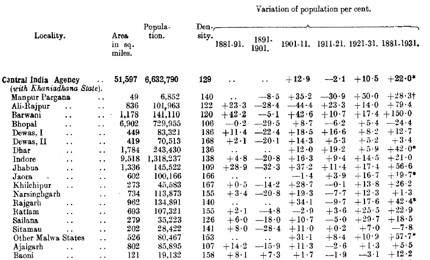
The Central India Agency deals with 61 Indian States situated roughly be tween Rajputana and the Central Provinces and occupying an area of 51,597 sq. miles including the British pargana of Manpur (54 sq. miles) and about 10 sq. miles of States territory under British administration.
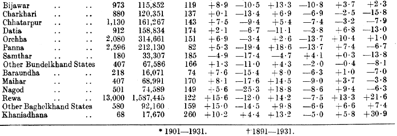
To them has been added for census purposes Khaniadhana State which is dealt with by the Gwalior Agency and has an area of 68 sq. miles. The total population dealt with is 6,615,120 in the Agency and 17,670 in Khaniadhana with a mean density of 129 per sq. mile. As a result of exchanges of territory with Rajputana and Gwalior there has been a net increase since 1921 of 66 sq. miles. The Agency is not a compact area but consists of " dissimilar tracts with different ph ysical and geographical environment and complex ethnically, culturally and linguistically. Broadly speaking three areas may be recognised. They are Malwa, Bundelkhand and Baghclkhand ". The States with which the Agency deals are described as " bewildering in variety as regards their area, population, income, degree of internal autonomy and their relationship with the paramount power ".
Some half dozen or more of these States are compact areas, but the great majority constitute " a medley of interlaced territories and the Agency itself is a mosaic of fragmented sovereignties ". Malwa with its undulating plains and black soil and the fertile Narbada valley, although associated with the inhospitable Vindhya and Satpura hills, contrasts very markedly with the hilly, sandy and stony country of Bundelkhand and Baghelkhand. The west, that is the former, grows cotton, wheat and jowar, the latter, the eastern parts, grow rice and kodon. The former is a favoured region generally free from seasonal calamities, and the latter though with a higher average rainfall is more subject to drought and scarcity.
The decade economically has been one of comparative prosperity, free from famine or serious scarcity in any large area and from any widespread epidemic. Malwa was short of rain in 1925 and 1929, Bundelkhand and Bagelkhand in 1928 and 1929. The increase in population for the whole agency since 1921 has been 10 . 5%, ninety-two per cent of which increase is natural, only eight per cent of it being due to the favourable balance of migration.

