Floods in Delhi
This is a collection of articles archived for the excellence of their content. |
Contents[hide] |
History
The major floods in Delhi were in 1924,1955, 1978, 1988, 1995, 1998, 2010, 2013, 1963 and 2010. An analysis of flood data showed that the trend of flooding increases in September and decreases in July.[2023 was thus the exception]
Causes
2023
Priyangi Agarwal, July 14, 2023: The Times of India
New Delhi: Floodplain encroachment, vanishing wetlands and the 25 bridges on the path of the Yamuna in Delhi have aggravated the flooding of the river, experts have concurred. Rain is not the only culprit.
The facts on the ground bear this out. In the last four days, Delhi has seen little or no rain but the river has risen and risen. A lot has been said about the release of water from the Hathnikund Barrage in Haryana. However, the numbers don’t add up well for this argument, either. It is a point that Bhim Singh Rawat, a Yamuna activist and associate coordinator of South Asia Network on Dams, Rivers and People (SANDRP), illustrated with numbers.
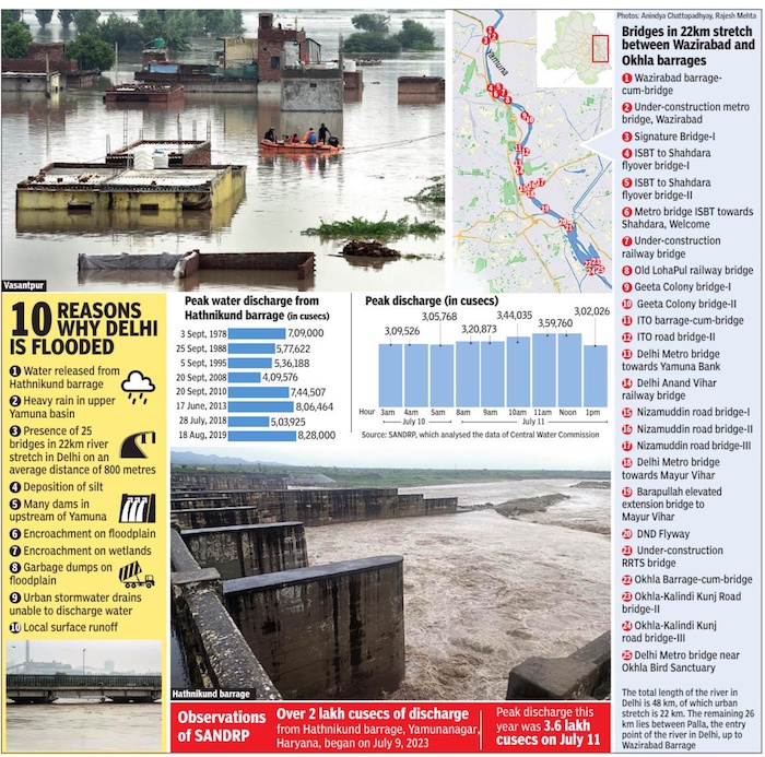
“The data of the Central Water Commission shows that the peak water released from the Hathnikund Barrage is 3. 59 lakh cusecs this year. Data reveals that over 8 lakh cusecs were released from Hathnikund in 2019 and 2013, but the flood situation was not as bad then as it is now. Even the cumulative water released from Hathnikund this year does not appear to be more than what was released in 2019 and 2013,” Rawat said. In 2019, the level of the Yamuna rose to 207. 25 metres. In 2019, it rose to a little over 206 metres.
Rawat pointed to the bridges. “In the 22-km stretch of the Yamuna, from Wazirabad barrage to Okhla barrage in Delhi, there are 25 bridges at an average distance of 800 metres. The bridges obstruct the smooth passage of flood water and affect the hydrology of the river. ” He added that as mining and dredging activities continue in Yamuna’s upper segment and such activity doesn’t happen in the Delhi stretch, “the level of riverbed rises in the city and leads to deposition of silt”. This can be controlled by humans as the river is unable to flush out the silt.
CR Babu, professor emeritus and head of the Centre for Environment Management of Degraded Ecosystems (CMEDE), said there are many dams/barrages upstream in Haryana and Uttarakhand, which release massive quantities of water when there is heavy rain in the catchment areas.
“Rivers have floodplains which are 5-10 km wide and take the floodwater smoothly downstream so that there is no flooding in human settlements on edges of river. However, at the western side of Yamuna, at ITO, there is no floodplain. It was encroached upon for development. The 5-km floodplain has catchment wetlands which impound excess flood water. However, the floodplain here has shrunk and the catchment wetlands have disappeared,” Babu said.
He too pointed out that the bridges resist the flow of the river. “Huge dumps of solid waste stiremain on the floodplain, offering resistance to the flow. ”
Chandra Bhushan, CEO of the International Forum for Environment, Sustainability and Technology (iForest), said the encroachments on the floodplain is well documented, but little has been done to remove them. “Flyovers, bus stops and garbage dumps have come up. Flooding is natural as river width has reduced. ”
Manu Bhatnagar, principal director of the natural heritage division at INTACH, said the scenario can be broken down into two factors — external and internal. “Heavy rain has been recorded in the upper Yamuna basin, causing increased flow and flooding. Stormwater drains cannot discharge water as the level in the river is high. Due to concretisation, surface run-off is humongous. The water does not get absorbed in the soil. The city needs to be spongy,” he said.
YEAR-WISE DEVELOPMENTS
1978

From: July 14, 2023: The Times of India
See graphic:
Floods in Delhi, some statistics, 1978 onwards
2023
July 12, 13
Abhinav Rajput & Pragya Kumar, July 14, 2023: The Times of India

From: Abhinav Rajput & Pragya Kumar, July 14, 2023: The Times of India
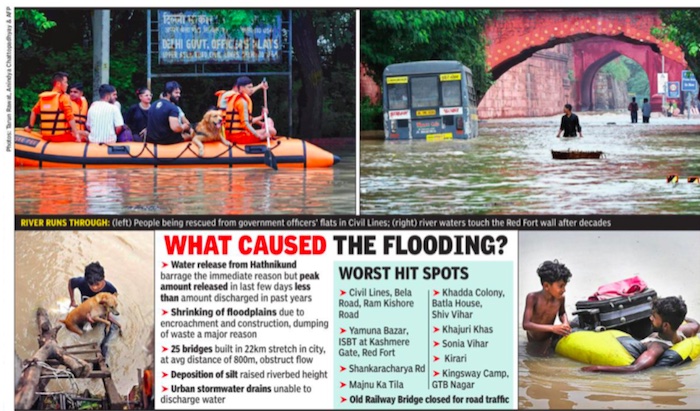
New Delhi: Continuous water discharge from the Hathnikund barrage in Yamuna Nagar district of Haryana on Thursday led to the worst flooding in the capital in 45 years. The water began flowing into some of Delhi’s main arteries like Ring Road and GT Karnal Road and inundated the residential area of Civil Lines and transport hub ISBT at Kash mere Gate besides the low-lying areas near Kalindi Kunj.
After three critical water plants had to be closed because of ingress of water, late at night, the authorities were struggling to repair and open some gates at the ITO barrage and also fix a DJB regulator near the Indraprastha Metro station which collapsed under pressure, threatening to throw water further into the city, towards Mathura Road.
However, Central Water Commission (CWC) held out some hope. The water level at the Old Railway Bridge at 8 pm was 208. 66 metres, three metres above the danger level. CWC said that between 2am and 4am on Friday, the level was expected to fall to 208. 45 metres after which it was likely to decrease gradually.
By 10pm, the water had receded slightly to 208. 63. However, conflicting reports from Hathnikund and UP on likelihood of a further rise on Friday left Delhiites guessing after a nerve-wracking day when traffic disruptions, visuals of people wading through water and NDRF teams rescuing residents in distress dominated the day’s news.
Over 23,000 people have been evacuated so far and those taking refuge in Delhi government shelters number 21,092, an official bulletin said. “Precautionary and proactive relief and preventive measures” were being undertaken in Sonia Vihar, Mukherjee Nagar and Hakikat Nagar, which are susceptible to flooding.
Water lapping against the walls of Red Fort harked back to the old days when Yamuna used to flow there. Mangi Bridge, where earlier traffic often used to get stuck, had so much water that vehicles found it impossible to go through.