Jubbulpore Division , 1908
This article has been extracted from THE IMPERIAL GAZETTEER OF INDIA , 1908. OXFORD, AT THE CLARENDON PRESS. |
Note: National, provincial and district boundaries have changed considerably since 1908. Typically, old states, ‘divisions’ and districts have been broken into smaller units, and many tahsils upgraded to districts. Some units have since been renamed. Therefore, this article is being posted mainly for its historical value.
Jubbulpore Division
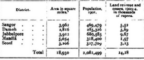
Jabalpur — Northern Division of the Central Provinces, lying between 21 degree 36' and 24 degree 7' N. and 78 degree 4' and 81 degree 45' E., with an area of 18,950 square miles. The head-quarters of the Commissioner are at Jubbulpore City. The Division contains five Districts, as shown below : —
- The District figures of area and population have been adjusted to allow for some
small transfers of territory since the Census of 1901.
Of these, Saugor and Damoh and the Murwara tahsll of Jubbulpore lie on the Vindhyan plateau to the north ; the southern part of Jubbul- pore is situated at the head of the narrow valley through which the Narbada river flows between the Vindhyan and Satpura" ranges ; while SeonI and Mandla form part of the Satpura plateau to the south. The Division therefore consists generally of hilly country, lying at a con- siderable elevation and enjoying a comparatively temperate climate. In 1 88 1 the population of the Division was 2,201,573, which increased in 1 89 1 to 2,375,610 or by 8 per cent. The increase was considerably below the average for the Province, the decade having been an unhealthy one, especially in Saugor and Damoh.
In 1901 the popu-
lation was 2,081,916, a decrease of 12 per cent, on the figures of 1891.
Since the Census a small transfer of territory has taken place, and the
adjusted population is 2,081,499. All Districts of the Division suffered
severely from famine during the decade. In 1901 Hindus formed
74 per cent, of the total and Animists 20 per cent. There were
89,731 Musalmans, 29,918 Jains, and 5,878 Christians, of whom
2,706 were Europeans and Eurasians. The density of population is
no persons per square mile, as compared with 112 for all British
Districts of the Province. The Division contains ir towns and 8,561
inhabited villages; but Jubbulpore City (90,316) and Saugor (42,330)
are the only towns with a population of more than 20,000. Thirteen
miles from Jubbulpore, at a gorge overhanging the Narbada river, are
the well-known Marble Rocks.
