Kanker
Contents[hide] |
Kanker
As in 1908
This section has been extracted from THE IMPERIAL GAZETTEER OF INDIA , 1908. OXFORD, AT THE CLARENDON PRESS. |
Note: National, provincial and district boundaries have changed considerably since 1908. Typically, old states, ‘divisions’ and districts have been broken into smaller units, and many tahsils upgraded to districts. Some units have since been renamed. Therefore, this article is being posted mainly for its historical value.
Feudatory State in the Central Provinces, lying between
20 degree 6' and 20 degree 34' N. and 8o° 41' and 81° 48' E., with an area of
1,429 square miles. It is bounded on the north by Drug and Raipur
Districts ; on the east by Raipur ; on the south by the State of Bastar ;
and on the west by Chanda. The head-quarters are at Kanker, a vil-
lage with 3,906 inhabitants, situated on a small stream called the
Dudh, 39 miles by road from Dhamtari station on the Raipur-Dham-
tarl branch of the Bengal-Nagpur Railway. Most of the State consists
of hill and forest country ; and except in the eastern portion along the
valley of the Mahanadi there are no extensive tracts of plain land, while
the soil of the valley itself is interspersed with outcrops of rock and
scattered boulders. The Mahanadi enters Kanker at a short distance
from its source, and flows through the eastern part of the State,
receiving the waters of numerous small streams from the hills. Gneiss
of a granitoid character is the prevailing rock formation. The prin-
cipal forest trees are teak, sal (Shorea robusta), sirs a (Dalbergia lati-
folia) and bljasal (Pterocarpus Marsupiuni), The ruling chief belongs
to a very old Rajput family, and according to tradition his ancestors
were raised to the throne by a vote of the people. During the supre-
macy of the Haihaivansi dynasty of Chhattisgarh, the chief of Ranker
is shown in an old record as in subsidiary alliance with the ruling power,
and as having held the Dhamtari tract within their territories. Under
the MarSthas the Kanker State was held on condition of furnishing
a military contingent 500 strong whenever required. In 1809 the chief
was deprived of Kanker, but was restored to it in 181 8 by the British
Resident administering the Nagpur territories, on payment of a tri-
bute of Rs. 500. This was remitted in 1823 on the resumption by
the Government of certain manorial dues, and since then no tribute
has been paid. The present chief, Lai Kamal Deo, was installed in
1904. The population in 1901 was 103,536, having increased by 26
per cent, during the previous decade. Gonds form more than half the
total, and there are also a number of Halbas. Chhattisgarhl and
Gondi are the languages spoken.
The soil is for the most part light and sandy. Nearly 300 square
miles, or 2 1 per cent, of the total area, were occupied for cultivation in
1904, and 284 square miles were actually under crop. Rice covers
nearly 130 square miles and kodon 32. The cultivated area has
increased largely in recent years. There are 21 tanks which irrigate
about 350 acres. The recent opening of a branch line to Dhamtarl
has brought the considerable forests of the State within reach of the
railway, and a large income is obtained from sales of timber. About
333 square miles are tree forest. The State contains 51 miles of
metalled and 75 miles of unmetalied roads; the principal metalled
road is from Dhamtarl to Ranker.
The total revenue in 1904 was Rs. 1,56,000, the principal heads of receipt being land revenue (Rs. 67,000), forests (Rs. 60,000), and excise (Rs. 20,000). The incidence of land revenue is less than 4 annas per acre of cropped area. The principal items of expenditure were Rs. 45,000 for the maintenance of the ruling family, Rs. 13,000 on general administration, Rs. 8,300 on police, Rs. 4,200 on education; and Rs. 3,400 on land revenue settlement. During twelve years since 1892-3 a total of Rs. 1,14,000 has been expended on public works, under the supervision of the Engineer of the Chhattisgarh States division. Besides the roads already mentioned, an office building, jail, schools, post office, and sarai or native travellers' resthouse have been constructed at Ranker. The State supports one vernacular middle and 16 primary schools, with a total of 1,316 pupils. Only 904 persons were returned as able to read and write in 1901, the proportion of male literates being 1.7 per cent, of the population. A dispensary is main- tained at Ranker. A Political Agent under the supervision of the Commissioner, Chhattisgarh Division, controls the relations of the State with Government.
Cave paintings
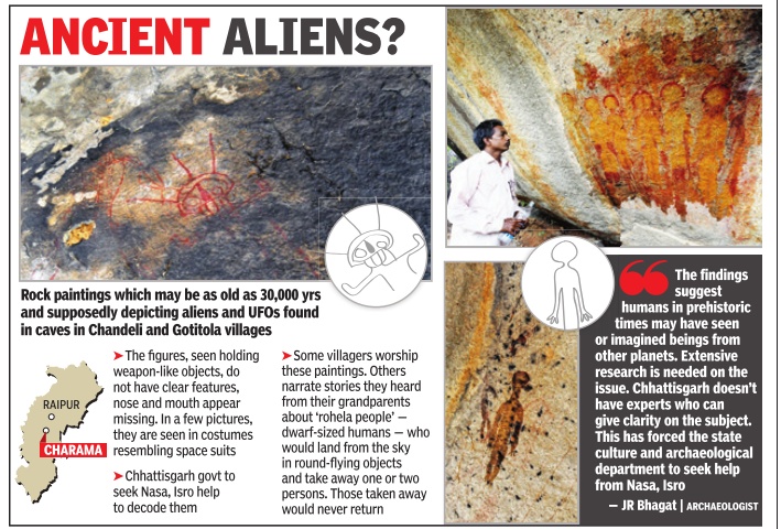
UFOs in cave paintings in Kanker district, Bastar
Scholars discover `UFOs' in Chhattisgarh rock paintings
Charama (Chhattisgarh)
The Times of India Jul 18 2014
Chhattisgarh government archaeologist J R Bhagat may have stumbled upon a startling discovery: he and his team have found cave paintings in Kanker district of Bastar which they believe depict UFOs and aliens.
The paintings are said to be of the same vintage as those in Bhimbetka, declared a world heritage site in 2003. Some of the paintings found in the Bhimbetka rock shelters are roughly 30,000 years old.
Rakesh Chaturvedi, director, Chhattisgarh department of archaeology , said “The findings suggest humans in prehistoric times may have seen or imagined beings from other planets.
