National Capital Region (India): Regional Land Use
This article has been sourced from an authoritative, official readers who wish to update or add further details can do so on a ‘Part II’ of this article. |
Contents |
The source of this article
Draft Revised Regional Plan 2021: National Capital Region
July, 2013
National Capital Region Planning Board, Ministry of Urban Development, Govt. of India, Core-4B, First Floor, India Habitat Centre, Lodhi Road, New Delhi-110003
National Capital Region Planning Board
National Capital Region (India): Regional Land Use
BACKGROUND
17.1.1 Statutory Provisions
Section 10 (2) of the National Capital Region Planning Board Act, 1985 states “The Regional Plan shall indicate the manner in which the land in the National Capital Region shall be used, whether by carrying out development thereon or by conservation or otherwise, and such other matters as are likely to have any important influence on the development of the National Capital Region”. Further, Section 10(2) (a) of the National Capital Region Planning Board Act, 1985 emphasizes that the Regional Plan shall indicate “the policy in relation to land use and the allocation of land for different uses”. The Regional Land Use Plan translates broad planning policies and proposals into physical (spatial) form to illustrate the manner in which land in NCR is to be used for various purposes. However, the reservation of areas for specific land uses which are of regional or sub-regional importance will be detailed out in the Sub-regional Plans and Master Plans/Development Plans which are to be prepared by the respective participating States within the overall framework of the Regional Plan.
17.1.2 Review of Regional Plan-2001
(i) Review of Regional Plan-2001 policies has brought out certain critical issues of large scale conversion of fertile agricultural land into non-agricultural use, and conversion of land along the transport corridors in Delhi urban area, Delhi Metropolitan Area (DMA) now Central National Capital Region (CNCR) and close to the metro and regional centres. (ii) In the NCR constituent States, land use control is exercised within notified controlled/development/regulated areas around towns through their existing Acts. However, no planning/development control is available outside the controlled/development /regulated areas.
LAND USE ANALYSIS
17.2.1 Existing Land Use Analysis for NCR 2012 NCR Planning Board commissioned a Study on “Creation and Updation of Land use/ cover for review of Regional Plan-2021” to National Remote Sensing Centre (NRSC), Department of Space, Government of India. The existing landuse analysis based on Resourcesat-2 LISS-IV data pertaining to 2012 was carried out by NRSC as part of the Study.
The results indicate that “agriculture use”, which includes cultivated land, fallow, plantation and
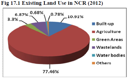
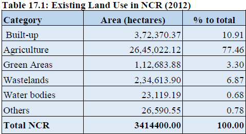
horticulture is the predominant use of land in the region (77.46%) (refer Table 17.1 and Figure 17.1).
Sub-region wise distribution of agricultural land reveals that Haryana sub-region has recorded highest
area under agriculture use, which constitutes 41.83% of the total agricultural land of NCR, followed by
U.P. (34.35%), Rajasthan (21.89%) and NCT-Delhi sub-regions (1.93%) (Table 17.2).
“Built-up area” which includes residential, non-residential built-up, open, vacant, recreational airport, railway station, yard, landfill sites, etc. constitutes 10.91% and is the second largest use of land in NCR. Haryana sub-region has the highest concentration (35.46 %) of the area under "built up" category in NCR followed by U.P. (33.29%), NCT-Delhi (22.43%) and Rajasthan sub-regions (8.82%).
“Wastelands” includes gullied land, saline land, waterlogged, barren, rocky and river sand, and constitutes 6.87%. The highest concentration of “wastelands” has been recorded in Rajasthan sub-region constituting 74.46% of the total wastelands of NCR followed by Haryana (18.23%) U.P. (5.23%) and NCT-Delhi sub-regions (2.03%).
“Green Areas” are non-agriculture vegetated areas which include dense vegetated area including forests, plantation and open scrub and constitute 3.30% of the NCR. Rajasthan sub-region has the highest concentration of green areas consisting 42.11%, followed by Haryana (32.78%), UP (19.54%) and NCTDelhi
sub-regions (5.57%).
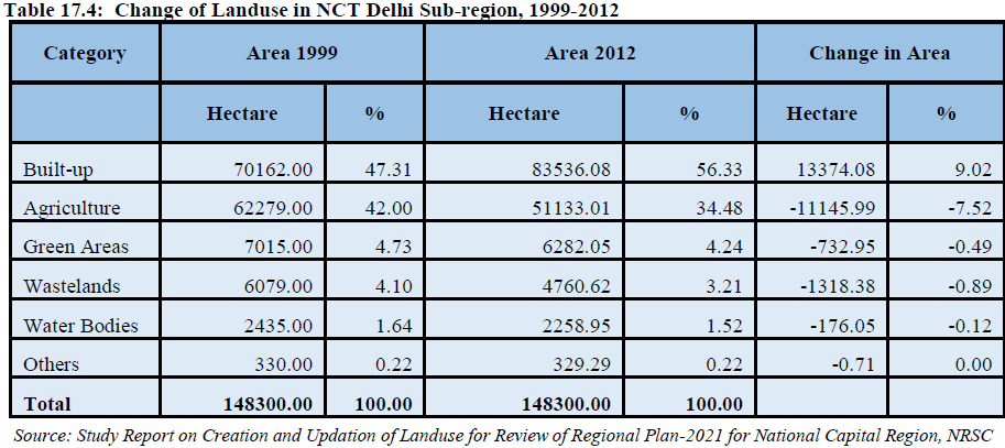
“Water bodies” include rivers/streams, canals, drains, lake/ tank/ pond, etc. and constitute 0.68%. Haryana sub-region has the highest share of area under water bodies constitutes 41.78%, followed by U.P. (37.60%), Rajasthan (10.85%) and NCT-Delhi sub-regions (9.77%). “Others” includes stone quarrying, brick kiln constitutes 0.78%. In the case of land under “other uses”, Haryana sub-region has the highest share of 56.56%, followed by U.P. (36.77%), Rajasthan (5.53%) and NCT-Delhi sub-regions (1.24%). Sub-region wise analysis of land uses is given in Tables 17.4 to 17.6. The spatial distribution of land use at regional level for 2012 is indicated in Map 17.1 (National Capital Region: Existing Land Use 2012).
17.2.2 Temporal Landuse Change in NCR, 1999-2012
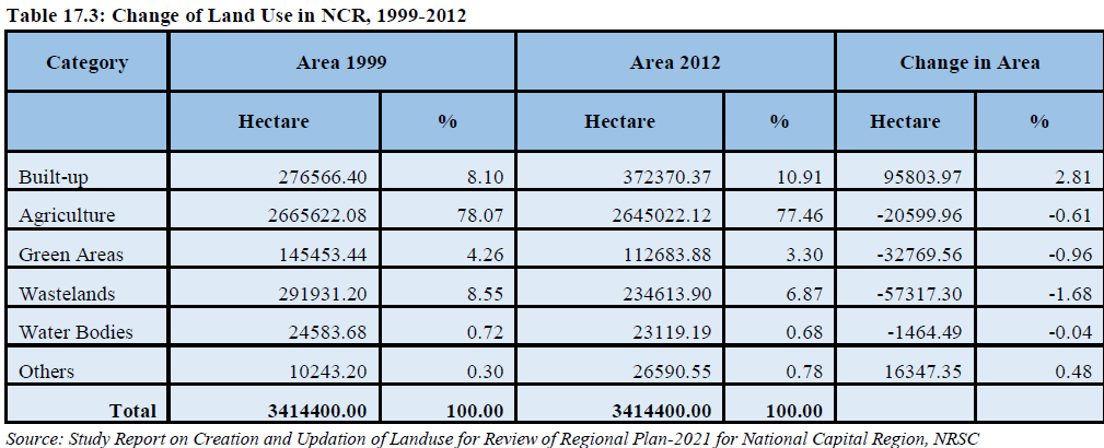
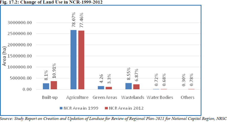
Landuse change analysis indicates that during the period 1999-2012, built-up area has increased by 2.81% (95803.97 ha.) from 8.1% to 10.91% of the total geographical area of NCR, while the area under agriculture use has reduced marginally from 78.07% to 77.46%, green areas have reduced marginally from 4.26% to 3.30%, wastelands have reduced from 8.55% to 6.87%, water bodies have decreased from 0.72% to 0.68%, while area under others have increased significantly from 0.3% to 0.78% (Table 17.3. and Figure 17.2).
17.2.3 Sub-Region wise landuses in NCR
NCT-Delhi Sub-Region
Existing Status (2012): In the NCT-Delhi Sub-region, built-up is the predominant use which constitutes 56.33% of the total area of the Sub-region, followed by agriculture use (34.48%), green areas (4.24%), wastelands (3.21%), water bodies (1.52%) and others (0.22%) (Table 17.4).
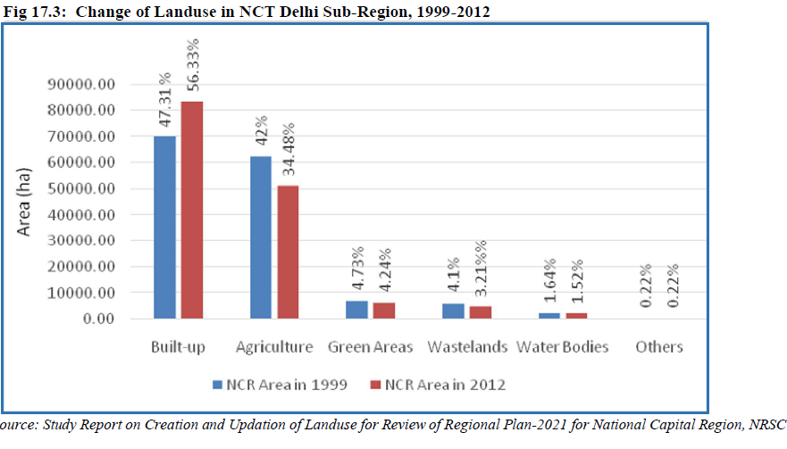
Temporal Change (1999-2012): Land use change analysis indicates that during the period 1999-2012, the built-up area increased from 47.31% to 56.33%, registering an increase of 9.02% during the last 13 years. Area under agriculture use has reduced from 42% in 1999 to 34.48% in 2012. Green areas marginally reduced from 4.73% in 1999 to 4.24% in 2012. In the case of wastelands, the area reduced from 4.1% to 3.21% and area under water bodies has marginally reduced from 1.64% to 1.52%, whereas other landuse did not change during the period 1999-2012 (Table 17.4 and figure 17.3).
Haryana Sub-Region
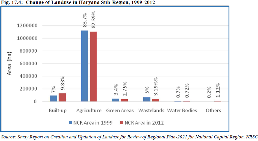
Existing Status (2012): In Haryana Sub-Region, the predominant use is agriculture use which constitutes 82.39% of the total area of the Sub-Region followed by built up (9.83%), green areas (2.75%), wastelands (3.19%), water bodies (0.72%) and others (1.12%) (Table 17.5).
Temporal Change (1999-2012): Land use change analysis indicates that during the period 1999-2012, the built-up area increased by 2.83 % from 7% in 1999 to 9.83% in 2012. In the case of agriculture use, the area marginally reduced from 83.7% in 1999 to 82.39% in 2012. Green areas marginally reduced from 3.4% in 1999 to 2.75% in 2012. Area under wastelands reduced from 5% to 3.19%, area under water bodies increased marginally by 261.09 ha, and area under others increased from 0.2% in 1999 to 1.12% in 2012 (Table 17.5 and Figure 17.4).
Uttar Pradesh Sub-Region
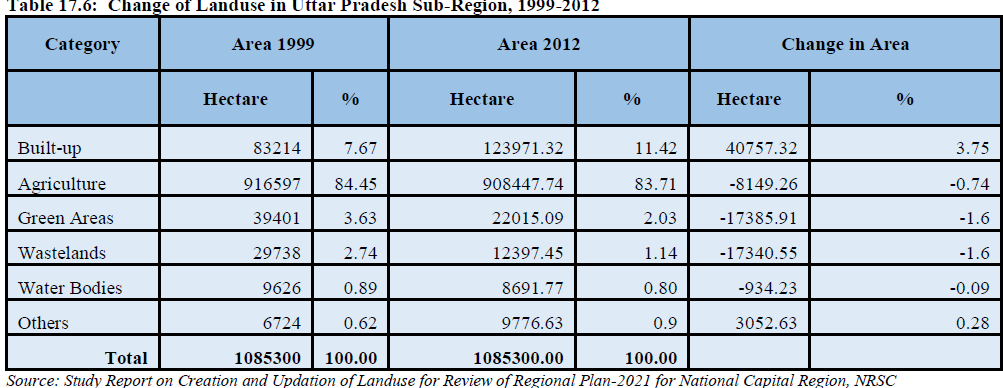
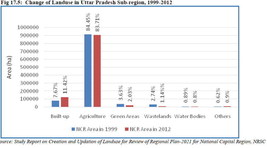
Existing Status (2012): In Uttar Pradesh Sub-Region, the predominant use is agriculture use which
constitutes 83.71%. Built-up area constitutes 11.42%, green areas 2.03%, wastelands 1.14%, water bodies
0.8% and others 0.9% (Table 17.6).
Temporal Change (1999-2012): Land use change analysis indicates that during the period 1999-2012, built-up area increased from 7.67% to 11.42%, registering an increase of 3.75% during the last 13 years. In the case of agriculture use, the area marginally reduced from 84.45% in 1999 to 83.71% in 2012. Green areas marginally reduced from 3.63% in 1999 to 2.03% in 2012. In the case of wastelands, the area reduced from 2.74% to 1.14%, area under water bodies recorded insignificant reduction from 0.89% in 1999 to 0.80% in 2012, and area under others marginally increased from 0.62% in 1999 to 0.90% in 2012 (Table 17.6 and Figure 17.5).
Rajasthan Sub-Region
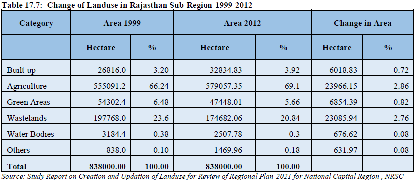
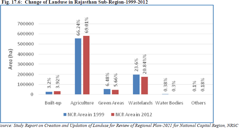
Existing Status (2012): In Rajasthan Sub-Region, the predominant use is agriculture use which
constitutes 69.10%. Built-up constitutes 3.92%, green areas 5.66%, wastelands 20.84%, water bodies
0.3% and others 0.18% (Table17.7).
Temporal Change (1999-2012): Land use change analysis indicates that built-up area increased from 3.20% in 1999 to 3.92% in 2012. In the case of agriculture use, the area increased from 66.24% in 1999 to 69.1% in 2012. Green areas marginally reduced from 6.48% in 1999 to 5.66% in 2012. The area under wastelands reduced from 23.6% to 20.84%, area under water bodies also marginally reduced from 0.38% in 1999 to 0.3% by 676.62 ha in 2012, and the area under others increased from 0.1% in 1999 to 0.18% in 2012 (Table 17.7 and Figure 17.6).
A comparative analysis of Sub-region wise existing land uses distribution in NCR-2012 is given below in
Table 17.8.
17.5 ZONING REGULATIONS
Keeping in view rapid urbanisation, environmental degradation and to ensure orderly development in the region, a legislative tool in the form of Zoning Regulation is required. In view of this, four broad zones have been identified for application of land use control and development and for enabling preparation for detailed Plans such as Sub-regional/Master/Development Plans/Local Area Plans. The elaboration of the land use details and zoning regulations be incorporated in the Sub-regional Plans and Master/Development Plans by the respective State Governments. Four broad zones and major activities/uses permitted in these zones are given below:
17.5.1. Controlled/Development/Regulated Zone
(a) Urbanisable Areas (including existing built-up/urban areas)
Within the urbanisable area proposed in the Master/Development Plan of the respective towns, the
functions and uses designated as under be continued:
i) Residential
ii) Commercial
iii) Industrial
iv) Government offices, public and semi-public
v) Recreational
vi) Utility services
vii) Transport and communications
viii) Open spaces, parks and playgrounds
ix) Graveyards/cemeteries and burning ghats
x) Man-made heritage areas
xi) Natural heritage areas/eco-sensitive areas/conservation areas
The local authority according to the prescribed uses in the Master/Development Plans will govern detailed land uses within the urbanisable area. The Master/Development Plans of all the towns will be prepared within the framework of the Regional Plan-2021 and Sub-regional Plans. In case any amendment is required in the Acts to implement the policies of Regional Plan-2021, the necessary amendments be done by the respective State Governments appropriately.
(b) Agriculture (Rural) Zone within Controlled/Development/ Regulated Areas
1) Agricultural, horticultural crops and cash crops
2) Dairy and poultry farming including milk chilling station and pasteurization plants
3) Social forestry/plantations including afforestation
4) Non-polluting industries registered as RSI/SSI units subject to one of the following conditions:
(i) Located within half kilometer belt encircling the existing village abadi and approachable from a public road/rasta other than scheduled road, national highways and state highways.
(ii) On public road/rasta not less than 30 feet wide other than scheduled roads, national highways and state highways outside the half kilometre zone referred to in (1) above up to a depth of 100 metres along the approach road.
Note: State Governments may further restrict setting up of industries as per Master/Development Plan provisions.
(5) Non-polluting agro-based industries on public roads/revenue rasta not less than 30 feet wide other than scheduled roads, National Highway and State Highway.
(6) The site should not fall within 900 metres restricted belt around defence installations.
(7) Land drainage and irrigation by hydro-electric works and tube well for irrigation
(8) Sanitary landfill, compost processing plant and other such activity sites with adequate protected belt as prescribed in the CPHEEO Manual and the notifications issued by the Ministry of Environment and Forests from time to time.
(9) Mining and extraction operations including lime and brick kilns, stone quarries and crushing subject to the rules and approved site.
(10) Bus queue shelter and railway station
(11) Airports with necessary buildings
(12) Wireless Station
(13) Grain godowns, storage spaces at site approved by competent authority
(14) Weather station
(15) Telephone and electric transmission lines and poles
(16) Cremation and burial grounds
(17) Fuel filling station, service stations and repair workshops
(18) Power plant/sub-station/water works/treatment plants and other utility services
(19) Storage godowns for inflamable petroleum products such as LPG, petrol, diesel, kerosene, aviation turbine fuel, light diesel oil and other petroleum products and lubricants with the approval of the competent authority
(20) Village houses within abadi-deh
(21) Farm houses outside abadi-deh, and
(22) Expansion of existing village contiguous to abadi-deh including social institutions like schools, dispensaries, veterinary centres and police posts if undertaken as a project approved or sponsored by the Central Government or State Governments or government approved private institutions.
(23) Recreational and Tourist facilities
(c) Green buffers
i) Approach/service roads
ii) Agriculture and horticulture
iii) Social forestry/plantations including afforestation
iv) Fuel filling stations with amenities like toilets, STD booths, small repair shop, small tea/soft drink and snack bar (with no cooking facility)
v) Toll Plaza, bus queue shelters, police booth, first aid centres and telephone booth
17.5.2 Highway Corridor Zone
(i) The Highway Corridor Zones will have to be notified as controlled/development/regulated area and Master/Development Plans will have to be prepared by the respective State Governments.
(ii) In the Highway Corridor Zones (excluding green buffers along highways) activities permitted in ‘urbanisable area’, ‘agriculture zone within development/controlled/regulated areas’ and the ‘green buffers’ prescribed in paras 17.5.1(a), 1(b) and 1(c) of Zoning Regulations will be permitted through Master/Development Plans.
(iii) Access to the expressways and highways will be regulated by the competent authority.
17.5.3 Natural Conservation Zone
In this zone the following uses activities may be permitted:
i) Agriculture and horticulture
ii) Pisiculture
iii) Social forestry/plantation including afforestation
iv) Regional recreational activities after obtaining environmental clearance from competent authority
17.5.4 Agriculture (Rural) Zone outside Controlled/Development/Regulated Areas The Study Group-I has suggested modifications/additions relating to educational and health facilities and solid waste management sites. The following activities/uses are permissible in addition to the activities/uses permitted in the “agriculture zone within controlled/development/regulated area” as indicated in para 17.5.1(b):
i) Intensive agriculture and allied activities such as dairying and poultry farming
ii) Afforestation specially on the wastelands and barren lands
iii) Regional recreational uses such as, regional parks, wildlife sanctuary
iv) Educational facilities, schools, educational and training institutions including engineering & medical college
v) Health facilities, Dispensaries and Primary Health Centres and hospitals
vi) Cemeteries
vii) Quarrying
viii) Brick kilns
ix) Existing village Mandis/agricultural markets
x) Rural industries
xi) Farm houses, and
xii) Solid Waste Management facilities
