Nepal earthquakes: 2015-16



This is a collection of articles archived for the excellence of their content. |
The authors of this article include…
Himanshi Dhawan The Times of India
The Times of India Deeptiman Tiwary
Keshav Pradhan, The Times of India
Briefly
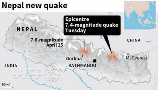
A massive 7.9 magnitude earthquake hit Nepal with devastating force less than 50 miles from the capital, Kathmandu, causing tremors in northern India as well, on 25 April 2015. It killed more than 8,000 people in Nepal and some in neighbouring India and Tibet.
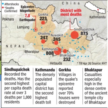
11 districts of Nepal, especially Sindhupalchok and Gorkha, were the worst hit.
Massive tremors were felt in Delhi, Lucknow, Kolkata, Silchar and other parts of northern and NE India. The quake in Delhi measured 5 on Richter scale.
There were several after shocks. (Details in the 'Aftershocks' section of this page.) The most severe aftershock was on 12 May 2015, around 1245 pm Indian time (afternoon) with an intensity of 7.3 on the Richter scale
The US Geological Survey said that the 12 May quake was deeper, coming from a depth of 18.5 kilometers (11.5 miles) versus the April 25th quake that hit 15 kilometers (9.3 miles)
A timeline
Day 1
Sat 25 April 2015
The aforesaid earthquake slid India up to 10 feet northwards in a matter of seconds, causing enormous damage, the gravity of which would emerge over the next many days.
Nepalese Prime Minister Sushil Koirala was in Indonesia for the Bandung Conference when the earthquake struck. He learned about the earthquake from Indian PM Narendra Modi's tweet. When Mr Koirala called Mr Modi he mentioned that Mr Modi's tweet was his first source of information on the earthquake.
Mr Koirala immediately started preparing to return home.
Day 2
Mr Koirala reached Nepal and held an all party meeting in which he said that his government was sending desperately needed tents, water and food supplies to those in need
Nepal scrambled to organize quake relief, as many fled the capital
Hundreds were cremated near the Pashupatinath temple
Social media appeared to have beaten the traditional media with governments, various agencies and individuals using Twitter and Facebook to connect, rescue and provide relief.
Day 3
There were fresh tremors in Nepal, and people vacated buildings
The rains couldn't have come at a worse time for the thousands of people in Kathmandu waiting in the open for news from hospitals about the wounded and dying. As passengers shivered in temperatures that were brought down by the rain to about 13 degrees Celsius, there were no taxis to take them either home or to the hotel.
At the Tribhuvan International Airport at about 9pm, hundreds of Indians had gathered outside the terminus, wet and hungry. They would probably spend the night standing, pushing and shoving each other for a centimeter more space on earth that kept shaking through most part of Day 2. Inside the airport, guards sat forlornly as passengers could get neither food nor water. "Everything is shut, everything is dead," said a policeman.
A little beyond, at Baluwatar, near the Bhat Bhateni super market in the heart of the city, most residents had left their houses and were sleeping in a community centre. Young men stood guard, to warm them in the event of fresh tremors and to drive away thieves.
Day 4
Heavy rainfall raised fear of epidemic outbreak in quake-hit Nepal
Nepal was short on everything — shelter, fuel, food, medicine
The Nepalese PM, Mr Sushil Koirala, said that rescue operations were not effective. PM Koirala declared three days of national mourning. India had already done so.
In solidarity with its brethren in Nepal, the Government of India had declared national mourning and cancellation of all official entertainment on Day 2 itself.
In the first four days, most quake-hit areas went without food, shelter and medical aid. Whether it was the Kathmandu Valley or farflung Rasua, Sindhupalchowk and Gorkha districts bordering Tibet, there was widespread anger and resentment against Koirala and his government.
Koirala had not been keeping well for some time.
Day 5
250 people were reported missing after a fresh mudslide in Ghodatabela village in Rasuwa district, a popular trekking area
Prices for essential foodstuffs soared. A pack of powdered milk is going for Rs 400 although it has Rs 212 printed as the MRP. Some taxi drivers asked for Rs 5,000 from the airport to Thamel, a Rs 800-ride in normal times.
The home ministry has threatened “strong“ action against those involved in fleecing an already desperate people.
There was an exodus out of the capital. On Day 4, around 80,000 left, in a single day.
The quake shook the faith of some, but turn lucky survivors into believers overnight
Pakistan beefs up its food aid to Nepal
Britain’s Daily Mail reported: Nepal was left with an unsavoury taste in its mouth after receiving packets of ‘beef masala’ as part of the relief package from Pakistan. [See picture]
According to Hindu belief, eating beef is a religious offence since the cow is a sacred animal and treated on a par with one’s mother. Nepal was for long the world’s only Hindu state. The first royal order officially prohibiting cow slaughter stated that the punishments for the crime were death and confiscation of all property of the offender. However, an amendment in 1990 to the Civil Code made cow slaughter punishable by 12 years in prison.
The first Civil Code of Nepal, the Muluki Ain of 1854, had stated: “This kingdom is the only kingdom in the world where cows, women, and Brahmins may not be killed.”
The place of origin of these [Pakistani beef masala] packets was Nowshera Cantt in Pakistan. The food items had been manufactured by PANA Force Foods. These packets also prominently mention that these are not for sale and the contents include ‘potato bhujia’ and ‘beef masala’.
Tasneem Aslam, spokesperson for Pakistan’s ministry of foreign affairs, initially washed her hands off the matter: “I am not responsible for the dispatch. The relief aid is sent by [Pakistan’s] National Disaster Management Authority.”
The National Disaster Management Authority (NDMA), Pakistan had dispatched, inter alia, 200 food packs (2.6 tonne) and 1,000 Meals Ready to Eat (MREs) from the NDMA’s stocks.
How did the Pakistanis react when news of this gross insensitivity reached them? Sameena Nazeer, a well-meaning journalist, liberal by Pakistani standards, called it ‘An Honest Mistake’ and wrote on Pakistan’s Daily Times: ‘Nepal’s authorities could serve beef food items to 1 million Muslims living in Nepal. It’s just the matter of rational distribution and proper management... In 2005’s earthquake, Pakistan too received some food items which were not acceptable to the local population but we still managed anyhow to accept them with gratitude. In emergency situations, even Muslims are allowed to eat pork and have its "Masala” if food is scarce.’
[All recipient countries take serious offence if external aid is directed at specific ethnic groups. How would Pakistan react if Iran were to send relief that only Pakistan's Shias can use?]
Pakistan's foreign office later dismissed the report, stating that ‘there was no beef content in the ready to eat food dispatched by Pakistan to Nepal.’
Tasnim Aslam added that ‘the people of Nepal really liked the food dispatched by Pakistan and even requested for more.’ Express Tribune.com.pk
Day 6
With initial rescue efforts focused on Kathmandu, many villages were without food and drinking water. Desperate, they survived on raw crops standing in their fields.
Villagers in many parts of Barpak and Gurkha regions -the quake's epicentre -which are completely cut off started dying a slow death. Quake induced landslides had wiped out long stretches of roads and most villages had no space for helicopters to land.
In these villages, there was no rescue, only relief effort. Indian Air Force choppers hovered over the villages. Several attempts were made to land as villagers looked up in desperate expectation, but the chopper simply could not land. It finally just dropped food, tents and blankets and flew off.
Day 7
Nepal quake survivors began looting relief convoys as complaints of tardy aid distribution piled up despite a glut of relief material clogging the airport and relief hubs. (The Times of India)
Most fatalities were reported from Sindhupalchowk, a district separated from Kathmandu by about 70km but by decades in time. 1,600 people had lost their lives so far, according to the district administration. Many more were yet to be pulled out from rubble. Little in terms of aid had reached here, though, prompting the attacks on relief trucks.
Locals spoke of how in the absence of basic first aid, seven people dug out alive in Golchhe after hours of effort, died later.
Fifteen-yearold Pemba Tamang was pulled out from the rubble of a hotel. He survived exactly 120 hours under seven floors in a space just enough to fit a couple of men. Nursing minor injuries at a field hospital, he narrated how two bottles of ghee and sporadic rain kept him alive.
Day 8
Saturday, May 2
The toll from the quake crossed 6,200
A 5-magnitude earthquake was observed near Pokhara, according to the US Geological Survey.
Slaughtering of animals or birds and selling their meat was banned in Nepal over fears of a pandemic.
At Durbar Square Bhaktapur, 100-odd people, including locals and men from Nepal Police, started lifting the debris of the 300-year-old Vatsala Temple with bare hands. Not that JCBs were in short supply , but the administration and people were determined to rebuild their cherished heritage and so stones with ancient carvings and artwork have to be removed carefully . “Using cranes will destroy the artwork. This is not debris. This is who we are,“ a municipality official said.
As happens in such situations, rumours start floating about. And Nepal is particularly susceptible to rumours without any basis.
Rumours about government taxes
People from across the globe offered help to the Himalayan nation. This has led many Nepalis to believe that their government was sitting on money and material sent by donors.
Nepal quelled these rumours, saying that it had not any imposed any tax on relief material sent by credible global or bilateral agencies and reputed organizations.
Finance minister Ramsharan Mahat said: “We have only introduced some restrictions to stop misuse of relief operations. Some vested interests have started a disinformation campaign calling it tax imposition. There's absolutely no tax on relief material.“
Mahat added, “We haven't got aid from anywhere in cash. Not a single penny has come to the state coffer…Some people are masquerading as relief organizers and trying to bring in their own commodities by dodging (customs) duty . To stop this, we have made it mandatory for them to give details of their cargoes, how they have collected them and whether they are sending them to government ware houses and distributing them directly .“
Thieves spread rumours about aftershocks
Hira Bahadur Thapa of Dolakha and Lalitpur's Rajendra Khadgi were `caught red handed' claiming that a `huge' earthquake was on its way. There have been reports that gangs of robbers are on the prowl looking to steal things left behind by people running out of their tents and houses after hearing rumours.
For the first time after the quake, Nepal police, at pains to quell misinformation about impending tremors and landslides, nabbed two men for the crime and sent them to jail.
Day 9
Airport shut
Authorities had to temporarily close Kathmandu's main airport to large aircraft delivering aid due to runaway damage. There were reports of cracks on the runway. The airport was built to handle only medium-size jetliners, but not the large military and cargo planes that had been flying in aid supplies, food, medicines, and rescue and humanitarian workers.
Relief goods for Nepal quake victims held up at customs: UN
Some of the relief material for survivors of Nepal's devastating earthquake was being held up at the country's only international airport because of customs bottlenecks, the United Nations said.
Nepal had exempted tarpaulins and tents from import taxes the previous day, but UN Resident Representative Jamie McGoldrick told Reuters the government had to loosen customs restrictions further to deal with the increasing flow of relief material.
"They should not be using peacetime customs methodology," he said. Material was piling up at the Kathmandu airport instead of being ferried out to victims, McGoldrick said.
Finance minister Ramsharan Mahat clarified, “There's no tax on relief material.“
Some leading Nepalese papers hit out at the national government for making it mandatory for all aid givers to work through the PM's Relief Fund.The government claimed it was done to check misuse of money raised in the name of earthquake survivors.
However, the Nepal government's caution was not misplaced, as will be seen below.
Misusing the opening of passages for relief
Smuggling of drugs and arms proliferated along the Indo-Nepal border after the earthquake, as cartels exploited the opening of passages meant for quick supply of relief aid for victims. Three men were arrested in the preceding week from India’s Etawah with 46kg of Kirmichya ganja, a variant that is locally produced in Nepal. One of the men revealed that drugs syndicates were deploying poor people for as little as Rs 1,800 to supply contraband to India.
#GoHomeIndianMedia
Indian TV channels offended local sensibilities with their insensitive and self-congratulatory reporting of the aftermath of the earthquake. The TV channels, with their penchant for shoving microphones at suffering victims, were accused of gross misconduct, in some situations even confronting security forces at the site of the devastation. They intruded into family cremations, questioned grieving relatives, and generally showed a picture that many Nepalese found to be cringe-worthy. They showed the efforts of the Indian Army, and Indian disaster-relief personnel at work in Nepal, in a glowing light.
Day 10
Monday May 4, 2015.
The death toll reached 7,276, police said.
'Dear rescue workers: thanks, but we can manage'
Nepal government urged foreign rescue workers in the quake-hit capital to return home because the major rescue work in Kathmandu and surrounding areas have been completed and that the remaining operations can be handled by local worker However, work remained in the villages and remote mountain areas and foreign aid volunteers could work with local police and army rescuers in those areas, the government said.
4,050 rescue workers from 34 different nations have flown to Nepal to help in rescue operations, provide emergency medical care and distribute food and other necessities.
Day 11
The toll escalated to 7,557
*
The New York Times, in its 3 May edition, in a story titled Hints of Normalcy in Katmandu, but Rebuilding Lies Ahead observed that ‘a growing number of its capital's millions of residents were packing up their tents, checking out of hospitals and preparing for the workweek.’
Therefore, the 'Timeline' section of the page that you are reading has not been updated in detail after Day 10, though other sections of the page have been updated whenever important facts about the Earthquake or subsequent developments came up.
Please see the Aftershocks section of this page, which is being updated every day.
The toll, the damage
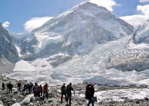
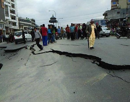

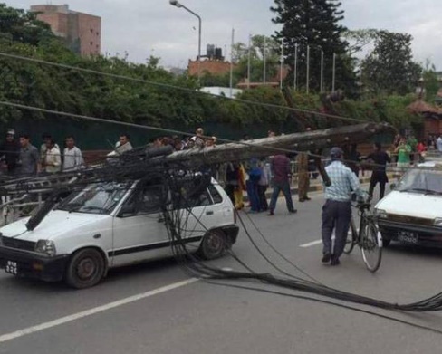
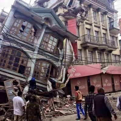


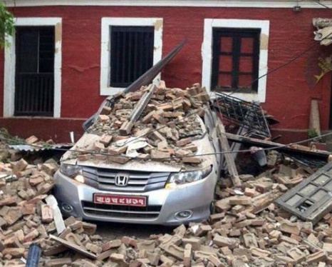
Estimates as on 14 May 2015
The death toll due to the earthquake of 25 April included 8,034 confirmed deaths, while the number of injured shot up to 16,390.
A total of 2,79,234 houses were completely damaged and 237,068 partially damaged. Of the checked houses, 50% were suitable for residing, 20-25% were unsuitable and the remaining needed renovations.
The second major earthquake of 12 May killed another 117 and injured 2,760 .
The PM's estimate on Day 4
On the 28th April, Nepalese PM Sushil Koirala had put the human toll at 10,000.
And, unfortunately, counting.
The PM’s round figure was obviously an estimate that included the ‘missing-and-out-of-contact, presumed dead’ because at that stage deaths confirmed by the Nepalese police stood at only half that number—-at 5,045. The disaster also injured more than 10,000, the police had then said.
The geographical spread of the casualties
Though the largest number of casualties were reported from Kathmandu and Sindhupalchowk, the destruction in the Barpak-Gurkha region was massive. An aerial survey showed village after village flattened. All of Barpak’s 100-odd houses were completely flattened by the quake.
In the interiors of Nepal, where village after village was completely flattened, children suffered the most. With the earthquake striking during daytime, most adults were working in the fields, leaving their kids at home. As houses collapsed like packs of cards, the parents escaped without a scratch but their children either died or were badly injured.
Some 50,000 pregnant women were likely affected by the devastating earthquake in Nepal, a UN assessment said.
Eight million people have been affected by the devastating earthquake, the United Nations said on Day 4. More than 1.4 million need food, while water and shelter are also in short supply, the UN said in a report.Hundreds of people are still trapped under tonnes of rubble in capital Kathmandu and some of the worst-affected remote mountainous areas.
Indians in Nepal
A young Telugu film actor died in the Nepal earthquake. K. Vijay, 25, was in Nepal along with the unit of Telugu movie etakaram.com for shooting.
Then came the tragic news that eight members of a Hindi-Urdu film starring Mugdha Godse and Ruslan Mumtaz, too had died.
The worst-affected areas
Nepal earthquake: Two highways of death and destruction
The Times of India Keshav Pradhan,TNN | Apr 29, 2015
Steeped in religion, the temple city of Kathmandu has two major exit routes to the outside world --- Arniko Rajmarg for "godless" China and Tribhuvan Rajmarg for India, Nepal's religious soul mate. In the districts through which the two highways pass, [25 April 2015]'s earthquake was as devastating as it was in its epicentre, Lamjung, Gorkha and Kathmandu Valley.
Of the three districts that the China-built 110km Arniko Rajmarg cuts through to reach the Tibetan border town of Khasa, Sindhupalchok is worst-hit. The other two districts on the way to Tibet are Bhaktapur and Kavre.
Until now, Sindhupalchok, dominated by Tamangs who follow Buddhism, initially reported more than 1,021 deaths, higher than anywhere else.
"Sindhupalchok is a picture of massive devastation. The situation is equally worrisome in Gorkha, Dhading, Nuwakot, Rasuwa and Kavre. Our choppers are engaged in taking the injured to hospital," says Banwarilal Mittal, a Nepali of Rajasthani origin who owns an airline in Kathmandu. Speaking to TOI, he adds, "We have so far rescued about 600 people from Everest and Annapurna base camps, Langtang, Rasuwa, Dhading, Gorkha and Nuwakot districts."
Tatopani, Jalbire, Barhabise, Chautara, Pipaldanda and Melamchi are among the settlements in Sindhupalchok that have suffered the most. A large number of houses and government buildings have collapsed and landslides have damaged roads that run alongside the Bhote Kosi, a tributary of the Kosi.
A bridge named Miteri Sanghu (bridge of friendship in Nepal) over the Bhote Kosi joins Tatopani with Khasa. Reports say about 20 people have died in Tibet's Shigatse situated across the bridge.
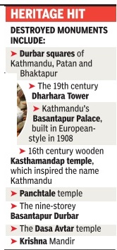
Sindhupalchok, Kavre, Bhaktapur, Kathmandu, Lalitpur (Patan), Nuwakot, Gorkha, Rasuwa, and Lamjung are among the worst-hit districts. Kathmandu, Lalitpur and Bhaktapur (all major centres of Newar civilisation) have lost a significant number of ancient temples and heritage sites. Similarly, the historic Gorkha Durbar has also suffered damage.
The destruction of a temple where the Gorkhas began their martial tradition in the 1600s came as a blow to the proud inhabitants of the region. The shrine, dedicated to Guru Gorakhnath, is part of the Gorkha Durbar, built in 1636. It's a matter of concern to the people that the temple of Guru Gorakhnath is devastated. It's where the ancient army unit, Guruji ko Paltan, was raised.
To the south of Kathmandu, the districts through which Tribhuvan Rajmarg passes have suffered widespread damage. This Rajmarg joins Narayanghat-Mugling Highway in Dhading district, which in turn merges with the India-built Mahendra Rajmarg in the Terai bordering Bihar and UP.
Dhading, Makwanpur, Chitwan districts lying between the hills and the low lands, Bara and Parsa districts (dominated by Bhojpuri-speaking people) and Dhanusha and Saptari districts (inhabited by Maithili speakers) in the Terai, have witnessed significant loss of life and property.
World Heritage sites
The head of Unesco--the United Nations cultural agency—said that a preliminary assessment of the famed World Heritage site around Nepal's capital was a "huge disaster" after the weekend's earthquake. Three of the seven places of worship in the extensive site in and around Kathmandu had been severely damaged. Nepal's other World Heritage site, a natural park around Mount Everest, was also damaged.
In India Across the Terai in Bihar, 58 people died, most of them in the border districts of East Champaran, West Champaran, Sitamarhi, Sheohar, Supaul, Madhubani, Araria and Darbhanga
In Tibet China's official Xinhua News Agency reported 25 dead in Tibet
Economy
Pushing 1m. people into poverty
Earthquake pushed 1 million Nepalese below poverty line: Report
The national crisis caused by the April 25 earthquake and its aftermath has pushed an estimated one million people below poverty line. (See Poverty: Nepal )
Presenting the findings of the Post-Disaster Needs Assessment (PDNA) report, National Planning Commission vice-chairman Govinda Raj Pokharel said it was estimated that the poverty-level would go up by more than 2.5-3.5 percent.
Trekking, tourism, mountaineering
Everest base camp
A 30-member Indian Army climbing expedition turned into a rescue mission at the base camp of Mount Everest. The Indian soldiers who had gone to peak the highest summit in the world escaped by the skin of their teeth. They then started working to save lives on the harsh terrain and will be the last to leave.
Their sole doctor treated about 80 injured, including foreign climbers and sherpas. Around 10 of them had suffered head injuries
19 were killed on the slopes of Mount Everest.
Around 15 bodies were also recovered and three people are known to have succumbed to their injuries on their way down from base camp, which is at a height of 17,700 ft. One Indian soldier who suffered a minor injury.
When the 7.9-magnitude quake struck, the soldiers and accompanying sherpas were on an acclimatization trek to Khumbhu icefall, some 300 ft above base camp. The zone is infamous for its unstable ice blocks. An avalanche at the same spot had claimed the lives of 16 Nepalese guides exactly a year before. The soldiers survived as many as three avalanches at the icefall on 25 April 2015, with three jawans suffering minor injuries.
There were around 1,000 people in Everest camps when disaster struck. Nearly 80-90% were evacuated within five days.
The team decided that it would be the last people to leave the site, after every other climber and sherpa has been evacuated.
Tourism hit
Travel agencies said there was near 90% cancellation of bookings with [Indian] traffic being diverted to other hill stations and even south-east Asian countries.
Only people with families in Nepal requested for bookings to the country
Pokhara: Business as usual
According to the US Geological Survey, the epicentre was 4 km closer to Pokhara than to Kathmandu, large parts of which have been reduced to rubble. Pokhara sits 73km east of the epicentre of the April 2015 quake, but the only evidence of a disaster were a few cracked walls.
So, two days after the disaster foreigners milled around a scenic valley lake, shopped, ate at cafes and signed up in groups for their next sporting pursuit.
Boat trips and paragliding continued in this town, which had been spared the destruction wreaked elsewhere. Thousands of visitors flock to the picturesque destination every year, attracted by its scenic mountain views, clear, dry winters and abundance of adventure sports
The Geo-tectonic aspect

Nature News, from which these two pictures have been taken, warns that the ‘risk of disastrous landslides in Nepal after the earthquake will linger for years.’
This picture shows a large section of Nepal as it looked from above in April 2014, one year before the major earthquake of April 2015.
Part of India slid 1' to 10' under Nepal
`Part of India slid 1 foot to 10 feet under Nepal'
The Times of India Apr 29 2015
A part of India slid about one foot to 10 feet northwards and underneath Nepal in a matter of seconds during the devastating 7.9-magnitude earthquake that hit the neighbouring country on Saturday, a US scientist has said.
“Saturday's slip took place over an area about 1,000 to 2,000 square miles over a zone spanning the cities of Kathmandu and Pokhara in one direction, and almost the entire Himalaya mountain width in the other,“ said Colin Stark, Lamont Associate Research Professor at the LamontDoherty Earth Observatory , Columbia University .
“A part of India slid about one to 10 feet northwards and underneath Nepal in a matter of seconds,“ Stark said. “The rock (we call it the “crust“, or more precisely `lithosphere') below Bihar slid under Nepal along a zone from Bharatpur, through Hetauda, to Janakpur,“ Stark said.
“It's important to realize that all of northern India is sliding north under Nepal etc, all the time. The point is that the sliding takes place abruptly at different patches at different times,“ Stark said. It is known that the entire subcontinent is being driven slowly but surely underneath Nepal and Tibet at a speed of around 1.8 inches per year, Stark said.
Over millions of years, the squeezing has crushed the Himalayas like a concertina, raising mountains to heights of several miles and triggering earthquakes on a regular basis from Pakistan to Burma.
Kathmandu rose 80cm...
Kathmandu is now 80cm taller
The altitude of the Kathmandu Valley rose by 80 centimetres (31.5 inches) after the devastating earthquake of April 25, 2015, the survey department said. The department came to the conclusion after conducting a 24-hour GPS survey four days after the 7.9magnitude earthquake struck the country.
The Kathmandu valley was at 1,338 metres from the sea level before the earthquake. Now the altitude of the valley is 1338.8 metres.
… while the Everest shrank by an inch...
The devastating earthquake that has rocked Nepal not only killed thousands but may have also shrunk the height of the world's tallest peak -Mount Everest -by about 2.5cm, according to analysis of satellite data.
The tallest mountain in the world, Mount Everest (8,848 metres), got a bit shorter, Live Science reported.
The information came from Europe's Sentinel-1A radar satellite. Scientists are racing to interpret the Sentinel data, which were made available in early May 2015 just hours after the satellite passed over Nepal.
A month later, Chinese authorities said the geophysical impact of the devastating quake did not change the height of the world’s tallest peak. [1] Xinhua
…and moved 3cm/ 1.2 in. southwest
Mount Everest shifted southwest due to Nepal earthquake
The world's tallest peak, Mount Everest, moved three centimetres (1.2 inches) to the southwest because of the Nepal earthquake that devastated the country in April.
The 7.8-magnitude quake reversed the gradual northeasterly course of the mountain, according to the National Administration of Surveying, Mapping and Geoinformation.
Before the quake, Everest had moved 40 centimetres to the northeast over the past decade at a speed of four centimetres a year, the report said. The mountain also rose three centimetres over the same time period.
The earthquake caused an avalanche on Everest, killing 18 people and leaving its climbing base camp in ruins. It prompted authorities to cancel all climbs for 2015.
Of the wo earthquakes, on April 25 and May 12, the second quake, which had a magnitude of 7.3, did not move the mountain, China Daily said
Tibetan township moved 60cm south, county sank 10cm
[timesofindia.indiatimes.com/world/south-asia/Tibetan-county-and-township-move-60-cms-due-to-Nepal-quake/articleshow/47346371.cms? Press Trust of India]
A township and county in have moved 60 centimetres southward as a result of the devastating Nepal earthquake last month, a Chinese geologist said on Tuesday.
The Tibetan township of Gyirong and Nyalam County, which border Nepal, have shifted about 60 centimeters, said Wang Qi, a professor with the China University of Geosciences
According to Wang, the massive quake on April 25 resulted in the movement of the Indian Plate and the Eurasian Plate. "Gyirong and Nyalam are close to the epicenter, so their movements are obvious," he said.
The quake also resulted in the sinking of Nyalam by about 10 centimeters, he added.
Tsho Rolpa, glacial lake, disturbed?

Tsho Rolpa, one of Nepal's biggest glacial lakes, is located at a height of 4,580 metres in Dolakha district. It has been a subject of concern for years because the lake has been swelling due to increased glacial melts and is held back by a fragile natural dam.
There were concerns that 12 May’s 7.3 magnitude temblor in Nepal may have disturbed the glacial lake, which is not far from the quake's epicentre.
Nepal's ministry of science, technology and environment said that it was continuing to monitor the ake after Tuesday's quake. As per the latest informa ion, there is no indication of any danger, it said. However, the ministry's department of hydrology and meteorology , urged people living downstream to be on alert as aftershocks of the April 25 earthquake were continuing to hit the region.
Experts have for years been warning about the danger of flash floods in the wake of disasters such as earthquakes which may further destabilize the already unstable glacial lakes in the Himalayas. The epicentre of 12 May's quake lay on the Dolakha-Sindhupalchok, just tens of kilometres west of Tsho Rolpa. Experts say the risk posed by the lake is high not only because its swelling waters are being held back by a weak moraine, but also because it has two hanging glaciers high above it.
The earthquake was inevitable
Ancient collision made Nepal earthquake inevitable
KENNETH CHANG, The New York Times News Service | Apr 27, 2015
More than 25 million years ago, India, once a separate island on a quickly sliding piece of the Earth's crust, crashed into Asia. The two land masses are still colliding, pushed together at a speed of 1.5 to 2 inches a year. The forces have pushed up the highest mountains in the world, in the Himalayas, and have set off devastating earthquakes.
Experts had warned of the danger to the people of Katmandu for decades. The death toll in Nepal on [25 April 2015] was practically inevitable given the tectonics, the local geology that made the shaking worse and the lax construction of buildings that could not withstand the shaking.
Himalayan Nepal's earlier earthquakes
GeoHazards International, a nonprofit organization in Menlo Park, Calif., that tries to help poorer, more vulnerable regions like Nepal prepare for disasters, had noted that major earthquakes struck that region about every 75 years.
In 1934 — 81 years [before] — more than 10,000 people died in a magnitude 8.1 earthquake in eastern Nepal, about six miles south of Mount Everest. A smaller quake in 1988 with a magnitude of 6.8 killed more than 1,000 people.
Brian Tucker, president and founder of GeoHazards, said that in the 1990s, his organization predicted that if the 1934 quake were to happen again, 40,000 people would die because of migration to the city where tall, flimsily built buildings would collapse.
In an update [in April 2015], GeoHazards wrote, "With an annual population growth rate of 6.5 percent and one of the highest urban densities in the world, the 1.5 million people living in the Katmandu Valley were clearly facing a serious and growing earthquake risk."
The organization helped set up a local nonprofit to continue preparations, including the reinforcement of schools and hospitals.
[25 April's] earthquake occurred to the northwest of Katmandu at a relatively shallow depth, about nine miles, which caused greater shaking at the surface, but at magnitude 7.8, it released less energy than the 1934 quake.
Roger Bilham, a professor of geological sciences at the University of Colorado who has studied the history of earthquakes in that region, said that the shaking lasted one to two minutes, and the fault slipped about 10 feet along the rupture zone, which stretched 75 miles, passing under Katmandu.
The earthquake "translated the whole city southward by 10 feet," Dr. Bilham said.
Aftershocks as large as magnitude 6.6 have occurred mostly to the northeast of Katmandu.
It is possible that the [April 25] quake is a preface to an even larger one, but Dr. Bilham said that was unlikely.
Katmandu and the surrounding valley sit on an ancient dried-up lake bed, which contributed to the devastation. "Very, very soft soil, and the soft soil amplifies seismic motion," Dr. Tucker said.
Steep slopes in the area are also prone to avalanches like the one that the quake triggered on Mount Everest on [April 25, 2015].
[Juddha Shumsher Jang Bahadur Rana was the PM of Nepal in 1934. He is mainly remembered in history for the public execution of Dharmabhakta Mathema, Shukraraj Shastri, Gangalal Shrestha and Dashrath Chand, Nepal's first martyrs who fought for freedom from autocratic Rana rule. However, after the 2015 earthquake, with hindsight, the Rana PM’s efficient handling of relief and rescue work started being recalled with admiration.]
Geological interpretations
Indian subcontinent’s quake-causing collision course
By Kenneth Chang
May 18, 2015
In terms of plate tectonics, the Indian subcontinent is running into the rest of Asia at one and a half to two inches a year, leading to earthquakes.
When an unstoppable force like the Indian subcontinent crashes into an immovable object like the Eurasian plate, the consequences include the tallest mountains in the world and a cadence of earthquakes like the magnitude 7.8 one that struck Nepal and a major aftershock in the same region.
Many of the geological questions about the collision remain unanswered. How did the Indian subcontinent get so quickly to where it is today? How big was India originally? Even the simplest of questions are up for debate, with researchers offering answers that differ by some 30 million years.
“It’s going to be hard to convince anyone,” said Oliver E. Jagoutz, a geologist at M.I.T. and part of a team that outlined its ideas about the collision in the journal Nature Geoscience.
Another mystery is why India is still moving at a quick pace — one and a half to two inches a year — driving the devastating earthquakes.
“That is one of the biggest problems that we have in plate tectonics,” said Douwe J.J. van Hinsbergen, a professor of earth sciences at Utrecht University in the Netherlands. “It may not seem much, but it’s the rate at which your fingernails grow.”
The geologists are like accident investigators trying to decipher what happened from the wreckage, pondering how rocks from the ocean floor ended up high in the Himalayas. Much of the evidence, namely the chunk of India that is now jammed under Tibet and the Himalayas, is out of reach.
Still, until about a decade ago, scientists thought they had the story essentially figured out.
Throughout Earth’s four-and-a-half-billion-year history, the hulking chunks of land have alternated between periods of combining into supercontinents like Pangea 300 million years ago and periods like today when they are moving apart.
At the height of the age of dinosaurs, Pangea had broken into two giant continents, Laurasia and Gondwana, and India was a piece of Gondwana, in the Southern Hemisphere, attached to Antarctica and nestled between Africa and Australia.
More than 100 million years ago, India broke away and accelerated northward. According to the widely accepted picture, that runaway continental fragment collided with Eurasia 50 million to 55 million years ago in one of the few places today where a piece of continent runs into a continent rather than an ocean plate.
New analyses of the magnetism preserved in rocks suggested that the southern edge of Eurasia was farther north than some had thought, raising the question of whether India was close enough to make contact with Asia by then.
The revised magnetic measurements suggest that southern Tibet was 1,000 kilometers south at most. “Suddenly you have this huge space,” Dr. Molnar said. “Where was India 50 million years ago? Well, India was way south of where southern Asia was. So you have a choice: You have to make northern India be enormous or you have to put an ocean in there.”
Others pointed out that the most obvious effects of a continental collision, like the raising of the Tibetan plateau, did not start until later, perhaps 10 million years later. The rocks in the western Himalaya region also point to two collisions, not one.
“The jury was in,” said Simon L. Klemperer, a geophysicist at Stanford. “The jury is out again.”
Another key question: How much of India has disappeared? If the collision occurred more than 50 million years ago, almost 2,000 miles of India must have been pushed under Asia. A piece of continent this large would appear to be too big to fit the available space in ancient Gondwana.
And yet scientists agree that something collided 50 million to 55 million years ago, clearly seen in an uplifted seafloor of this age in the northern Himalaya region.
“That is why people said there is a collision between two continents,” Dr. van Hinsbergen said. “Which is true. That is the best conclusion you can draw. The question is not so much whether there is a continent colliding 50 million years ago. The question is whether that is India.”
In 2007, Jonathan Aitchison, now a professor of geosciences at the University of Queensland in Australia, put together an alternative timeline. The collision that people thought was India meeting Asia was actually India running into an arc of islands south of Asia, and India then pushed these islands like a snowplow into Asia 20 million years later. “We believe the evidence shows India bumped into other things before Asia,” Dr. Aitchison said. His hypothesis was widely dismissed.
Dr. van Hinsbergen came up with a different idea. He proposed that 70 million to 120 million years ago, India split in two as it was moving north. The first piece reached Asia 50 million to 55 million years ago, as dictated by the conventional picture, but the main part lagged behind, not colliding until 20 million to 25 million years ago.
That would make India small enough to fit into Gondwana. Tectonic plates are known to break apart — India was once connected to Madagascar, before splitting away in its northward sprint — but other scientists are skeptical, citing the lack of any geological evidence of an ocean crust separating two pieces of India.
Dr. van Hinsbergen replies that missing ocean crust is no more unlikely than missing continent. “Whatever was there disappeared without a trace,” he said. “Then the question is, what was it?”
Dr. van Hinsbergen does not find the island arc hypothesis compelling, and Dr. Aitchison is equally unconvinced by the suggestion of India breaking in two before colliding with Asia.
Dr. Jagoutz and Leigh H. Royden, a professor of geology and geophysics at M.I.T. looking at rocks in the western Himalaya, have come to a conclusion similar to Dr. Aitchison’s — that India ran into an island arc before it hit Asia — put the second collision about five million years earlier. In the Nature Geoscience paper, Dr. Royden and Dr. Jagoutz show that the island arc could explain the swiftness of India’s travels. About 80 million years ago, India was barreling north at half a foot a year, a pace it maintained for 30 million years.
Generally, the motion of continents is driven by subduction zones — where one tectonic plate passes beneath another and then descends into the Earth’s mantle, pulling everything behind it.
Geologists knew there was one subduction zone where the Indian plate dived under Asia. With an island arc between Asia and India, there would have been two subduction zones pulling on India, which could explain the high velocity of India.
But none of this explains why India is still so moving so fast. Whatever was north of India has long since disappeared into the mantle, and continental crust does not provide the same downward pull.
“It’s yet to be resolved what keeps India moving to the north,” Dr. Royden said. “At the moment, it’s still a work in progress.”
Geologists will be hard pressed to deduce what happened to India from the seismological data. Dr. Klemperer says he hopes that the mix of helium isotopes in geothermal springs will help tell whether the mantle below the Himalayan crust is part of the Indian plate or Asian plate.
“I agree the jury should still be out,” Dr. Klemperer said. “If I want to hold onto my view, then I need to eventually be able to demolish the arguments.”
The engineering aspect
Damage could have been greater
Nepal quake could have been much worse: Here's why
It's the many buildings that made it unscathed through the earthquake that amaze Kit Miyamoto.
"It could have been so much worse," said Miyamoto, head of a global earthquake and structural engineering firm, who flew to Nepal soon after he heard about last weekend's 7.8- magnitude quake. Before landing, he'd envisioned a flattened moonscape of dust and debris. He thought as many as 40,000 people could be dead.
That the reality has turned out to be far less destructive has a lot to do with the vagaries of geology, geography and construction decisions. Not to mention sheer luck.
"If a magnitude 6 or 6.5 quake happens within 20 kilometers of Kathmandu, it's going to be a nightmare," said Sandeep Donald Shah, a structural engineer with Miyamoto International. "The probability is pretty high that this may happen because we just had a (huge) earthquake, and the fault line has been activated."
The general state of Kathmandu's buildings — with their ancient soot-and-exhaust-stained concrete, their uneven bricks, their drooping facades and crooked balconies — raises questions about how so many still stand after such a big quake.
Remaining upright depended on a combination of factors, including age, size, building material and strength, location and the underlying soil. But the simplest explanation is that Kathmandu largely sits outside the danger zone of April 2015’s quake.
Because the epicenter was about 80 kilometers (50 miles) from the capital, the quake's power had partially dissipated by the time it got to Kathmandu, said Miyamoto, who is also a seismic safety commissioner for the state of California.
Even so, some of Kathmandu's remaining buildings look "very bad, seismically speaking," with weak foundations and structures, Miyamoto said. They've also been "softened up" by the quake, making them more likely to collapse or be seriously damaged if another, closer quake hits.
The region will likely see aftershocks for another year, including some big ones, Miyamoto said, but it's impossible to predict where or when they will occur. The two biggest aftershocks [in the next seven days were] more than 60 kilometers (38 miles) from Kathmandu.
The Nepal quake released 16 times the energy of the 2010 Haiti earthquake, where death estimates ranged from 100,000 to 300,000, yet the death toll in Nepal [stood] at more than 6,600. This is a huge loss of life, but far less than recent estimates that 100,000 people might die in Nepal's next major earthquake.
At some big hotel compounds it's almost as if the quake never happened: honking geese wander over manicured lawns and foreign guests start their days with hot showers before lining up at brimming breakfast buffets, eyes locked on phones connected to Wi-Fi.
You can go blocks sometimes without seeing any obvious earthquake damage.
Outside the gates, even many of those whose homes weren't ruined slept out in the open for days after the quake because of fears of aftershocks. In some closely packed quarters, there is spectacular damage, with tall buildings leaning against their neighbors like tipped dominoes. Many villages in the countryside, outside the capital, have been virtually flattened.
Generally, the older and bigger the building, the worse off it fared. So the so-called old city, home to many of Kathmandu's precious world heritage buildings, is obliterated in places.
In the final equation, buildings collapse, or stand, because of the power and length of a quake's shaking.
The strength of the shaking depends on the magnitude of the earthquake, the distance from the epicenter, the depth of the earthquake — shallower quakes do more damage than deeper ones — and the type of soil, according to Susan Cutter, director of the Hazards and Vulnerability Research Institute at the University of South Carolina.
While both the Haiti and Nepal quakes were shallow — 10 kilometers (6 miles) deep for Nepal, 13 kilometers (8 miles) for Haiti — the soil in Haiti made the shaking more severe and longer, Cutter said. Port-au-Prince was also much closer to the epicenter than Kathmandu — 25 kilometers (15 miles) rather than 80 kilometers (50 miles).
Old or unreinforced masonry normally fares poorly in an earthquake, though much depends on the quality of the materials and the building methods, as well as on building codes and their enforcement. If Nepal is far below most Western nations in terms of construction quality and code enforcement, most experts also believe it is better than Haiti.
Miyamoto, the structural engineer, called the damage in Nepal's capital, and the possibility that aftershocks could cause much more, a wakeup call. The government and outside nations, he said, should begin work to strengthen existing buildings and construct stronger new ones.
But that may prove difficult for Nepal's leaders.
Why Newari houses collapsed
Deeptiman Tiwary, The Times of India
From public structures to homes, Nepal might have unfortunately paid the price for preserving its architectural heritage.
Kathmandu to Bhaktapur, Patan to Sankhu -the four cultural seats of the country -it's mostly the old era, mud-brick and mortar homes that fell. In these cities' newer parts, where modern construction practices have been used, there's little or no destruction.
Although the Newari architectural culture has a history of quake-resistant houses, the older ones with rotting wooden beams and withering bricks couldn't have withstood a 7.9 quake. Had these been reinforced, fewer would have died. Nepal could have saved the character of our cities.“
Sankhu, a city of 10,000 around 20 km from Kathmandu, consists almost entirely of Newari homes. More than 60 died there, over half the houses collapsed. Among those standing, 30% are unlivable, their damages irreparable.
Punya Sagar Marhatta, architecture and urban planning scholar in Tribhuvan University has an explanation for the vulnerability of Newari homes to quakes. He wrote that records show traditional buildings using timber have failed to resist quake impacts.“Timber members have rotted or been permeated with insect holes. Such situations may have been overlooked by traditional artisans or they may have developed their own technologies to get rid of such situation. But such technologies and knowledge are unwritten. This added vulnerability to traditional buildings.“
Aftershocks
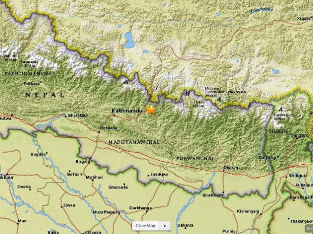
Between 26 April 2015 and 27 Jan 2016 the total number of aftershocks of magnitude 4 or more on the Richter Scale was: 427.
Of these
i) 70 of magnitude 3.2 or greater occurred between 26 and 30 April. [2])
ii) 140 aftershocks of magnitude greater than 4 were recorded between 26 April and 4 May.
iii) Between 26 April and 10 May 2015 the total number of aftershocks of magnitude 4 or more on the Richter Scale was: 157.
iv) Between 26 April and 12 June 2015 the total number of aftershocks of magnitude 4 or more on the Richter Scale was: 313.
There were no casualties or significant damage in any of these aftershocks: till 12 May, when at least 57 persons died.
Days on which significant aftershocks occurred included:
26 April
(the day after the main earthquake)
Two major aftershocks
A strong 6.7-magnitude aftershock epicentred in Nepal lead to tremors experienced in West Bengal, Bihar, Assam, Jharkhand, Odisha, Uttarakhand, Punjab, Haryana, Uttar Pradesh, Chattisgarh and Delhi for over 30 seconds at 12:42pm.
It was followed by another measuring 6.5 on the Richter scale.
Both tremors sent people running for open spaces. Climbers said the aftershocks caused more avalanches at Mount Everest.
There were a total of 38 aftershocks of various magnitudes on 25 and 26 April, mainly on the 26th.
3 May
Three tremors were recorded.
A quake measuring 4.5 on the Richter scale with its epicentre in Sindhupalchowk district was recorded at 3.29 a.m. A magnitude four aftershock, with its epicentre in Dhadig district, was recorded at 4.25 a.m. another tremor, having its epicentre in Gorkha district, was observed at 5.57 a.m.
4 May
At least eight aftershocks were recorded in Nepal.
Three earthquakes had epicenter in Nuwakot and others in Dolakha, Rasuwa, Gorkha and Sindhupalchowk.
The highest magnitude was of 4.7 with epicenter in Dolakha. At least five tremors were well felt in and around the capital Kathmandu.
8 May
Two fresh tremors were felt, both in districts east of Kathmandu.
Aftershocks continued to rock Nepal with two more mild tremors being felt in central Nepal this morning. The epicentre of the tremors being Sindhupalchowk and Dolakha districts.
i) A 4-magnitude tremor was felt at 2.19 AM in the morning with the epicentre at Sindhupalchowk district.
ii) A tremor measuring 5 on the Richter scale was felt at 6.17 am with the epicentre being at Dolakha.
10 May
Four tremors jolted Nepal
i) A 4.2-magnitude tremor was recorded at 1.50 am with its epicentre at Sindhupalchowk district, 100 km east of Kathmandu, one of the worst-affected districts.
ii) A 4.0-magnitude tremor was recorded at 2.44 am with epicentre at Udaypur district.
iii) The tremor of 4.4-magnitude which struck at 6.34 AM with epicentre at Sindhupalchowk/Tibet, according to the National Seismological Centre, Kathmandu.
iv) A tremor of 4.2 magnitude hit in the Kavre area.
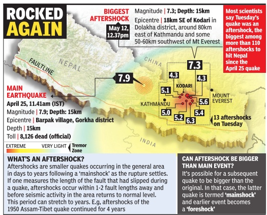
12 May 2015: 7.3 on Richter
The Times of India etc.
The day witnessed the most severe aftershocks since 25 April.
Four earthquakes and powerful aftershocks hit within an hour. The 1st struck around 12.46 pm (afternoon) Indian time and measured 7.3 on the Richter scale; the second measured 5.6; the third measured 5.5; and the fourth measured 6.2.
The powerful 7.3-magnitude earthquake violently shook the landmass on either side of Mount Everest, stretching to Lhasa in the north and Dhaka in the south.
The US Geological Survey said that the 12 May quake was deeper, coming from a depth of 18.5 kilometers (11.5 miles) versus the April 25th quake that hit 15 kilometers (9.3 miles)
The US Geological Survey added that the 7.3-earthquake, which shook Nepal at 12.45pm (local time) was epicentred 18km from Kodari, a rural settlement 80km east of Kath mandu and close to Tibet. The epicentre of the strong earthquake was close to Mount Everest. Namche Bazaar is the starting point for those who want to climb Mount Everest. The distance between Namche Bazaar and Mount Everest is about 30km
Reports said the impact of the earthquake was felt in Tibet's Jilong and Zhangmu regions as well as Lhasa.
Most of the damage has taken place in Sindhupalchowk and Dolakha districts. Kodari is located in Sindhupalchowk district, where the maximum deaths took place in April's earthquake. Twenty districts were hit this time.
Buildings collapsed in Chautara, Nepal. Many people were injured.
Three major landslides were reported in Nepal's Sindhupal chowk region, at least 12 were injured
The death toll from the 12 May earthquake is regularly updated and posted in the section 'The toll, the damage' above.
13 May
13 aftershocks jolted Nepal
May 15, 2015
A quake measuring 5.5 on the Richter scale jolted Nepal. The epicentre was in Dhading district, 52 km from Kathmandu.
May 16, 2015
Tremors measuring 5.5 on the Richter scale were felt in Dolkha, Nepal, with jolts in India's Bihar state as well.
June 11, 2015
A 5.3 magnitude tremor struck central Nepal
The quake was recorded at 9.57 pm (local time) with epicenter located at Sindhupalchowk district.
June 12, 2015
Two moderate earthquakes of 4.6 and 4.4 magnitudes struck Nepal.
The first quake was recorded at 1.22 am (local time) with its epicenter in Dolakha district, some 150 kilometres west of Kathmandu.
Another tremor of 4.4 magnitude was recorded at 10.19 am (local time) with epicenter in Dolakha district.
January 2016
There were aftershocks on 22 and 27 Jan 2016, measuring 4.6 and 4.2 on the Richter scale and with epicentres located in Nuwakot district (central Nepal) and Nepal's eastern Terai region bordering India respectively. Happily, no damage of life or property was reported. PTI pointed out that'According to the National Seismological Centre, the [latter] tremor recorded at 12:32 (local time) was the first felt in the region after last year's devastating earthquake...Nepal is divided into three regions: Himalayan region, Hilly region and Terai region. The Terai region is usually known as the grain house of Nepal for cultivating most of the crops in the country.'
Cracks in Mount Everest after earthquakes
The Times of India, Mar 26, 2016
Cracks and holes develop in Mount Everest after Nepal earthquake
Several cracks and holes have developed in the Mount Everest region due to last year's devastating earthquakes that killed about 9,000 people across Nepal, according to a specialist team responsible for maintaining the climbing route on the world's highest peak. "The great earthquakes of April 25 and May as well as a large number of aftershocks have caused some damage in the Everest region," Ang Tshering Sherpa, chairman of Nepal Mountaineering Association, said. "The ice-fall doctors fixing the ladders and ropes have informed that due to the cracks and holes developed on the slope of the mountain they need to fix more ladders this time," he said. Icefall doctors are Sherpa mountaineers charged with repairing the climbing route on Mount Everest. "This time we need 10 doctors, which is more than the usual number of six to fix the ropes and install aluminium ladders," Sherpa told Press Trust of India. They also need more time to fix the ladders due to the problem, he added.
So far, more than 440 aftershocks with magnitude 4 or more have hit Nepal after the two earthquakes in 2015. The Sagarmatha Pollution Control Committee (SPCC) has been authorised to fix ladders and ropes in the mountains.
The ice-fall doctors prepare the route from the base camp to usually camp I, paving the way for climbers to ascend the peak. However, it may also require to fix ropes in few places above the camp I. Due to the delay in fixing ropes, the climbers, who have already reached the base camp are yet to start their climb towards the peak.
Brotherly neighbours

India gave a massive thrust to its rescue and relief mission in quake-devastated Nepal - 'Operation Maitri' - pressing into service 12 heavy-duty military aircraft and 18 helicopters besides opening up four land routes to connect to Kathmandu and Pokhara valley to reach out to the affected with men and material.
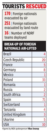
The joint Army-Air Force operation managed to evacuate 5,400 people by the third day, including 30 foreigners, who were stuck in Nepal. India had received requests from several countries to rescue their stranded nationals. Accordingly, India evacuated 170 foreign nationals from Nepal by the 4th day.
After the third day of relief and rescue operations, congestion in Kathmandu airport had forced four of India's military aircraft to return due to non-availability of landing space. Of the 18 helicopters, six had been kept on standby.
The government had deployed 10 teams of the National Disaster Response Force, each comprising 45 well-equipped personnel trained in disaster rescue operations. Three more NDRF teams were rushed on the 3rd day.
On the 3rd day, Indian soldiers were able to reach parts of the worst-affected Pokhra region, the epicentre of the temblor, by helicopters and dropped relief material. The Indian Army set up a camp at the epicentre.
The first focus was to restore the power in Kathmandu and other parts of the Himalayan state with the help of a team of Power Grid officials. New Delhi also sent another team from Indian Oil to ensure continuous fuel supply.
Four land routes were opened to Kathmandu, removing the blockage on Sunauli-Bhairawah link. Other routes opened for road traffic include the Janakpur and Raxaul-Birganj routes in Bihar and Mahendra Nagar in Uttarakhand. At least 100 buses with relief material, including food packets, water, medicines and equipment were dispatched by the 3rd day.
The government has sent one RO plant for restoring drinking water supply and oxygen regenerators. Army personnel on the 3rd day reached interiors of the Himalayan country. While the main Taskforce Hq operated from Kathmandu, a sub-hq was set up at Barpak Village in Gorkha district, the epicentre of the quake.
An engineering task force, consisting of 40 soldiers, five earth-movers and generators, was by then operational 5-km outside Kathmandu. The Kathmandu-Pokhara road was restored.
Six choppers were inducted in Pokhara for rescue and relief operations with the rest operating in Kathmandu and surrounding areas. The Army immediately set up a field hospitals at Radalgrah, near Lalitpur. In addition the Air Force has airlifted a rapid aero-medical team. Two more teams consisting of 18 medical teams with surgeons, were set to follow
The Army deployed six ambulances while the Shashtra Seema Bal sent 10 more to the quake- affected areas. The home ministry asked SSB to assist in rescue efforts through India's land routes to Nepal. Supply of relief material was carried out through these land routes.
The government of India also launched a national disaster helpline -011-1078—for people to access information.
