Floods in Assam, North-East India
| Line 13: | Line 13: | ||
[[Category:Places |A ]] | [[Category:Places |A ]] | ||
| − | |||
| − | |||
| − | |||
| − | |||
| − | |||
| − | |||
| − | |||
| − | |||
| − | |||
| − | |||
| − | |||
| − | |||
| − | |||
Revision as of 16:34, 17 June 2018
This is a collection of articles archived for the excellence of their content. |

2016: July-August
The Indian Express, August 7, 2016
Samudra Gupta Kashyap
Flood fury: Why Brahmapurta’s trail of destruction has become annual ritual in Assam
The Brahmaputra, one of the mightiest rivers in the world, runs through Assam like a throbbing vein, sustaining lives and livelihood along its banks. But every monsoon, the lifeline snaps, breaks all boundaries and causes widespread misery to about 20 of the state’s 32 districts.
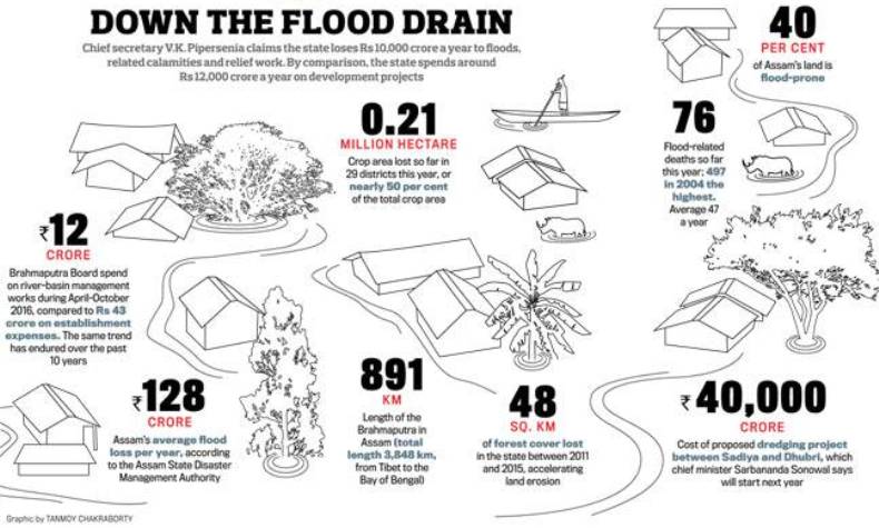
The Brahmaputra Valley is said to be one of the most hazard-prone regions of the country — according to the National Flood Commission of India (Rashtriya Barh Ayog), about 32 lakh hectares or over 40 per cent of the state’s land is flood-prone.
As another flood ravages Assam, displacing hundreds of people and damaging property worth crores, the question is, why does the the Brahmaputra spill over with such alarming frequency?
Experts say the problem begins with the embankments, the very structures that are meant to keep the flood waters away.
The embankments constructed along the banks of the Brahmaputra, its 103 tributaries, many of which come down from Bhutan and Tibet, and the Barak run into over 4,475 km. Many of these structures, constructed over a period of 25 to 30 years based on the 1954 recommendations of the Rashtriya Barh Ayog, show visible signs of ageing. “Though embankments don’t have specific life-spans, the ones in Assam are designed on the basis of flood data of 15 to 20 years and are supposed to remain fit for 25 to 30 years,” says a senior officer in the state water resource department. While natural wear and tear — surface run-off due to rain and rats digging burrows through the earthen structure — is one reason, most embankments across the state are also used as roads by villagers who ply motorbikes, bullock-carts, tractors, cars and trucks on them. Hundreds of families in Majuli and other flood-hit areas have made these embankments their homes by building bamboo houses on them. The gaping hole in the embankment wall at Dergaon, an Assembly segment in Golaghat district of the state, tells this story of how the embankment lost the battle to the river.
While it has been raining in different parts of the state since the first week of July, experts say the above normal rainfall in upper Assam and Arunachal Pradesh is not the only reason for the floods; environmental degradation in neighbouring hill states is part of the problem.
Only the Amazon carries more water than the Brahmaputra, one of the largest rivers in the world with an annual flow of about 573 billion cubic metres at Jogighopa, close to the Indo-Bangladesh border. But its waters carry a great deal of sediments, raising the river by about three metres in places and thus reducing its water-carrying capacity. Landslides and increasing topsoil erosion in the river’s catchment areas, particularly in Arunachal Pradesh from where come down most of the Brahmaputra’s major tributaries, have added to the river’s sediments.
As the river rages on, it eats into the soft alluvial soil of the state, eroding land along the banks. A recent study sponsored by the National Disaster Management Authority (NDMA) said the Brahmaputra had eroded 388 sq km of land in the state between 1997 and 2008. According to the state government, Assam has lost more than 4.27 lakh hectares — 7.4 per cent of its area — to erosion by the Brahmaputra and its tributaries since 1950. That has made the Brahmaputra among the widest rivers in the world, more than 15 km in places.
Since July 24, the Aie, a tributary of the Brahmaputra that comes down from Bhutan and flows through Chirang and Bongaigaon districts, has eroded more than 2 sq km of land in Chota-Nilibari and Dababeel villages. “The river simply swallowed our land. It was so swift that only a few families could remove the tin sheets, wooden doors and timber posts of their houses, apart from a few household items. What could we have done? You cannot remove the walls and the floor,” says Swapan Basumatary, 32, a marginal farmer who lost three bighas in Chota-Nilibari and whose family is now lodged at a relief camp in Subaijhar, Chirang district, with 46 other families.
According to the Brahmaputra Board, deforestation in Assam and its neighbouring states have accelerated the process of land erosion. According to the Forest Survey of India Report 2015, Arunachal Pradesh’s forest cover has reduced by 162 sq km between 2011 and 2015, Assam has lost 48 sq km of forest cover in the same period, Meghalaya 71 sq km, and Nagaland 78 sq km.
2017: July
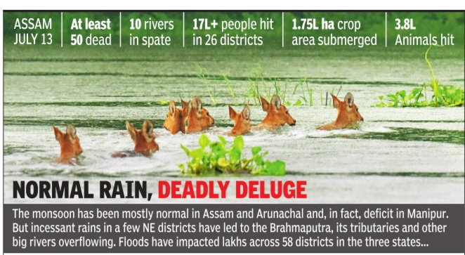
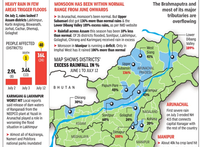
NORMAL RAIN, DEADLY DELUGE|Jul 14 2017 : The Times of India (Delhi)


